


2.29Mb (3225 downloads)
FSX
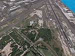
Alderney Airport (EGJA)-
located on the island of Alderney in the Channel Islands (UK).
I have travelled in and out of the island on many occasions
and, despite the lack general lack of information on the internet
about the airport, this is a pretty accurate representation.
Features include accurate control tower, accurate terminal building,
grass parking area, static aircraft, ground vehicles, car park,
fire-station, surrounding trees, perimeter fencing and more.
Many night textures and custom AFCAD file included. The airport
is at N49 42 44 and W002 12 88. This scenery is for FSX but
should also work under FS2004. It may even work in earlier versions
of FS but this is untested. Tim Clayton. 4.5MB
Posted Jun 23, 2008 14:16 by archive
0.31Mb (8542 downloads)
FSX
Modified Terrain Textures Config File.
. Flight Simulator X terrain is defined in the terrain.cfg file.
During testing, we have determined a certain number of modifications
to this file that will correct some problems with the FS world
and also provide more options for scenery designers. For example,
in some places, water bodies display rocky areas - this file
fixes that. Note: It does not smooth out the
terrain - just colors it so it isn't so obviously flawed. Richard
Ludowise, Luis Féliz-Tirado. 318K
Posted Jun 23, 2008 14:16 by archive
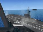
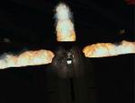
8.22Mb (21253 downloads)
FSX
- AI Carrier Scenery. This is just a demo, right, so no
complaints if there are any shortcomings. There are a few issues
whch I mention below but this scenery is just for fun and to
show what can be done with FSX. And this is just scraping the
surface! Roger Mole (Rollerball). 8.4MB
Posted Jun 23, 2008 14:16 by archive
42.73Mb (9047 downloads)
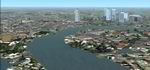
FSX/FS2004
Honolulu Airport Area Scenery.
This scenery contains high resolution ground scenery for the
airport of Honolulu Intl. (PHNL). It has a resolution of 1.2m/pix
(4.7m/pix is standard). Coverage is about 12*12 km and contains
the area around PHNL as well as the abandoned Ford Island NALF
(PNPS). Gottfried Razek. 43.7MB
Posted Jun 23, 2008 14:16 by archive
1.36Mb (4305 downloads)
FSX
Shuttle Launch Scenery 07.Updated.
.This is the scenery version for FSX. Fly into the area of the
Cape Canaveral and witness a launch..complete with effect attached
sounds..Updated are delayed launch engine startup sequence..Ground
blast effects..This is a full copy of (all) files needed to
overwrite (OR) install from new. Ron Jeffers. 1.4MB
Posted Jun 23, 2008 14:16 by archive
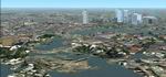
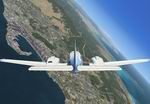
30.95Mb (6099 downloads)
FS2004/FSX
PHNL2006, Oahu-Honolulu, Hawaii (HI).
This packages contains photo scenery for the whole island of
Oahu in standard resolution of 4.7 m/pixel. By Gottfried Razek.
31.7MB
Posted Jun 23, 2008 14:16 by archive
19.42Mb (2499 downloads)
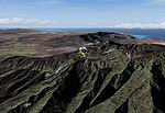
FSX
Sicily Version I.
The island of Sicily contains numerous communities. Of them
104 are represented presently escenario.Especialmente in the
coast. 5 airports exist but two aerodromes. Several sea ports
in the main ones cities. The architecture of their you marry
it seems a lot those of my millennial Catalunya. By Toni Agramont.
19.9MB
Posted Jun 23, 2008 14:16 by archive
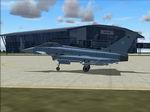
1.49Mb (3777 downloads)
FSX/FS2004
Rostock - Laage Airport, Germany.
This is the base of German Eurofighter. This scenery has over
150 objects, forest, airportsstreets and more. objects and textures
by www.afs-design.de - Author: A.Meyer. 1.5MB
Posted Jun 23, 2008 14:16 by archive
0.48Mb (1089 downloads)
FSX
Curlyo's Fun Antartic Scenery. This zip originally compiled
in fs9, and now working in FSX, contains a number of fictional
airports' with scenery, plus YMHB = Hobart Tasmania. The concept
for the zip was for multiplayer hops. However the zip can be
enjoyed solo Take a trip to the Antartic find what you can find,
and at times have a laugh. This scenery is created for fun is
is not meant to be accurate or realistic in any way. 490K
Posted Jun 23, 2008 14:16 by archive
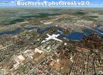
114.13Mb (3045 downloads)
FSX/FS2004/FS2002
Project Romania Bucharest photoreal Scenery Package v2.0.
The addon contains all seasons textures, night lights and water
textures.No autogen files yet. Victor Stephanovici. 117MB
Posted Jun 23, 2008 14:16 by archive