


13.83Mb (3435 downloads)
FSX
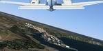
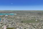
Corse Island scenery version I.
Known as Corse to the French, Corsica to the Italians and Corcega
to the catalans.includes scenery for 104 of 143 comunities on
the island along with seven airports Mountanous landscape represented
wit great fidelity. By Toni Agramont. 14.1MB
Posted Jun 23, 2008 14:16 by archive
0.62Mb (5740 downloads)
FSX
Taxiway Enhancement v1.
Taxi textures cover all taxi ways on FSX defualt airports all
around the world. These texture are made to serve us with enhanced
detail of the surface texture on the taxi way. - By Tom Knudsen.
241K
Posted Jun 23, 2008 14:16 by archive
0.24Mb (9088 downloads)
FS2004/FSX
Airport Light Environment v1.
This file redesigns all airport lighting for every airport in
both FSX and FS2004. This file will display exactly the same
in both FSX and FS2004 but the file is optimised to be used
with Bloom within FSX to give a fantastic, realistic feel to
the sim. By Luke Harvest. 241K
Posted Jun 23, 2008 14:16 by archive
1.45Mb (3522 downloads)
FSX
Forest Textures v2
. I re-designed the textures to suite the new Service Pack 1.
In this second version of FSX forest you now have an option
to use either 512x512 sized textures or the much faster and
greater 256x256 texture size as an alternative option. I also
re-designed the tree textures adding more effects like snow,
dead leaves, heavy snow and enhanced palms... In the same operation
i enhanced the small bushes to emphesize textures quality around
the country side. Tom Knudsen. 1.5MB
Posted Jun 23, 2008 14:16 by archive
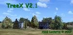
11.77Mb (7215 downloads)
FSX
Enhanced Trees (TreeX V2b).
It is a set of vegetable textures photorealist for FSX. They
are based on true photographs of trees of at least 1024x768
pixels. The trees were routed with the hand and reprocess chromatically
so as to keep a certain temperature of constant color. Separately
the snag trees, there are no naked trees (e.g. winter). You
will keep textures of origin for these trees but without canopy*.
All textures of these trees are represented without canopy (except
for two type of trees: acacias and olive-trees). Important
to remove any previous installation before installing
this version. Aimé Leclercq. 12.5MB
Posted Jun 23, 2008 14:16 by archive
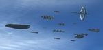
14.15Mb (3019 downloads)
FSX
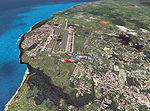
Rag Tag Fleet at PHNL Scenery:
This scenery adds: - The Battlestar Galactica Fleet at Honolulu
- in addition to Galactica, (search
'galactica') there are places to land within the fleet. They
are the Flatop,Colonial Defender and the docking bay of Cloud
9 * for MS-FSX By Bruce Fitzgerald. 14.5MB
Posted Jun 23, 2008 14:16 by archive
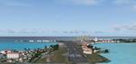
13.68Mb (16415 downloads)
FSX
North Caribbean Scenery Package.
Fully detailled scenery VFR and IFR of the Virgin islands and
the Leeward Islands in the North Central Caribbean That includes
the following islands: Beef, Anegada, Gorda,Tortola,St Johns,St
Thomas, St Croix.Anguilla, St Martin, Guadeloupe, St Barthelemy,
Saba, St Eustatius, St Kitts, Nevis, Antigua and Montserrat
57 islands and Cays in totally are represented wit yours towns
and installations.18 airports reconstructed and resized and
upgraded with new facilities. By Toni Agramont. 14MB
Posted Jun 23, 2008 14:16 by archive
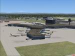
6.99Mb (5815 downloads)
FSX
Vancouver International Airport Version5.
The new International Terminal expansion has been added, the
main control tower has been rebuilt and the old control tower
removed, since it has now been demolished; I have completely
re-fenced the airport and put in a blast fence at the east end
of the north apron utilizing the default FSX fencing; Replaced
many objects with FSX default (a breeze to install with the
new SDK Mission Object Placement Tool), including ships in English
Bay, Caulfeild Cove and the Fraser River; the Point Atkinson
Lighthouse with a revolving light beacon inserted inside; and
some hangers; rebuilt the Iona Sewer Outfall and given it a
new beacon; applied appropriate landclass to SwishSwash Island
just south of the airport, and corrected the default land class
along the north side of Sea Island.). By P Nigel Grant, Vancouver.
7.1MB
Posted Jun 23, 2008 14:16 by archive
25.61Mb (4833 downloads)
FSX
Cuba Scenery Package.
It includes 93 airports renoved and much enhancements in the
landscape. 424 cities in his exactily coordinates are very detailled
and have colonial custom buildings and harbors. It includes
"Marine Heminguey" sport port of welcome of the USA
yachts that they rob in the island It permits flyngs VFR and
IFR. By Toni Agramont. 26.2MB
Posted Jun 23, 2008 14:16 by archive
81.18Mb (3136 downloads)
FSX/FS2004
Puerto Rico Western Area Scenery.
This package contains photo-scenery for the western part of
Puerto Rico. The scenery in standard FS2004-resolution of 4.7m/pixel.
It works equally well in FS2004 and FSX. Together with my Puerto
Rico East scenery you get full coverage of PuertoRico. Gottfried
Razek/http://www.blueskyscenery.com. 83MB
Posted Jun 23, 2008 14:16 by archive