


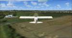
22.81Mb (750 downloads)
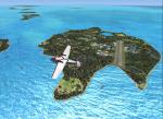
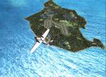
Custom remake of Little Darby and Darby islands in the Bahamas. Made just for fun.
Posted Mar 10, 2019 03:17 by Gary Shetter
5.31Mb (2645 downloads)
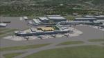
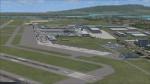
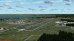
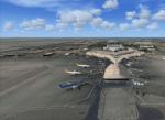
Daniel K.Inouye International Airport also known as Honolulu Intl (PHNL) Hawaii, USA.
This is a reasonably accurate and up-to-date version of Honolulu Intl airport with two optional files, and made only for FSX users, do not use in P3D: There is one version with the Crosswind runways activated where all 4 runways will be used for takeoff/landing and one version as the default airport runway operation: assigned parking as per their website with extra parking including gates for the A380, taxiways and taxi signs updated to the latest charts, hazardous cargo pad and buildings added, fuel tank farm, helipad, Lagoon Dr also included, support vehicle roads rebuilt and many other scenery improvements and objects added, airport views are from the roof of the control tower (when in tower view) please view the readme before installation. By Ray Smith
Posted Mar 7, 2019 01:30 by uploader
5.31Mb (347 downloads)
LFHC, Perouge-Meximieux forgotten in FSX. This airfield is located about 30 km north east of Lyon in France.
The location has been checked and corrected by SBuilderX, Taxiways, car parks created with ADE.
In order to make this scene more alive, I added the buildings (with Sketchup) some objects and people.
Posted Mar 3, 2019 06:59 by uploader
0.21Mb (282 downloads)
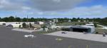
KTVC, Cherry Capital Airport, Traverse City Michigan USA, for FSX.
New setup of this airport. I used FreeMeshX for mesh. Tim van Ringen
Posted Mar 2, 2019 11:49 by uploader
1.30Mb (381 downloads)
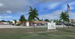
The home of the English rugby team, always visible to the south on westerly approaches to London Heathrow Airport.
Improved - now with rugby posts - as requested!
Posted Feb 21, 2019 18:44 by James Cartner


6.62Mb (1450 downloads)
"Texture Terrain HD for: FSX / P3D"
this time with the correct instructions for P3D users
1)texture 1024 x 1024: standard quality but the same is good
2)texture 2048 x 2048: more detailed high quality
-PREPAR3D
install : copy 1 texture "detail1.bmp" to:
.Prepar3D v4\Scenery\World\Texture
-Flight Simulator X
install : copy 1 texture "detail1.bmp" to:
C:\Program Files..\Microsoft Games\Microsoft Flight Simulator X\Scenery\World\Texture
delete the previous version of this add-on
Posted Feb 8, 2019 17:51 by juan30005
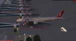
31.07Mb (710 downloads)
Flagler Executive (Florida) Airport (KFIN).
Flagler Executive Airport evolved from a WWII Navy training field to a dragstrip, to uncontrolled X47 airport, to KXFL with a control tower, and now to the KFIN designation. The airport has recently undergone a runway relocation and lengthening, taxiway changes and a name change. FSX shows the airport as X47 for the city of Bunnell, and it is now KFIN with this scenery update for the city of Palm Coast. This scenery package includes a photoreal airport background and models of actual buildings on the airport so you can fly in and have lunch at the Highjackers restaurant (your table has been reserved). The airport also has a water runway on adjacent Gore Lake. Scenery is based on Google Earth, Google street view and photos taken locally, and it is optimized for use with UTX-USA. Since changing the airport designator eliminates AI traffic previously programmed for X47, an AI traffic file is included as well as static aircraft to populate the airport. A modification is included for use with EditVoicepack to revise the ATC sound file to include "Flagler" in communications to/from the tower, etc. Includes fix. By: Art Poole
Posted Feb 4, 2019 07:45 by uploader
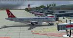
83.98Mb (1972 downloads)
Izmir Adnan Menderes Menderes Airport LTBJ in the west of Turkey for FSX/P3D. All of the Main Terminal and other buildings model have been designed using Sketcup 2018. ADE has been used parking,aprons and taxiway and taxisign and some objects.Free photo real satalite image from SBUilderX313. This also places a few objects from the default FSX scenery library. Before upload to fsx please read me file…Version LTBJHD2019V1. By Hakan DAGHAN
Posted Feb 4, 2019 03:07 by Hakan DAGHAN
46.82Mb (1493 downloads)
OKBK Kuwait International Airport Scenery v1.0.1 with Patch (v1.0.1b)
Posted Feb 1, 2019 05:11 by IVAO-Kuwaiti Division
3.99Mb (619 downloads)
Welcome to the Heart of Idaho!
The mountain country has to be seen to be believed. As one who grew up exploring
this part of the US I had the fortunate opportunity to do things that most just dream about. Who wouldn't want to
swim in hot-spring fed lakes, or pools? Idaho has more hot springs than any other state. Have you ever climbed up
to a pass at 10,000 feet? And then looked down at those who chose not to climb 1500 feet below, looked left at your
brother, and then looked over the pass at the mountain basin that begged to be explored. I did these things 58 years
ago. You can do it tomorrow if you want to.
This FSX adventure will take you to many places I have visited. It will also take you to places that I have not yet
visited. Some of the strips are difficult to get into. That is typical of mountain flying. Some are reasonable.
Your flying skills will be tested as you figure out the best approach.
The simulation consists of 19 airports in Central Idaho. Twelve existing strips have had improvements consisting of
strip surface improvements to allow all-season activity, and some eye candy. Seven new air facilities have been
added to the area.
Posted Jan 28, 2019 14:27 by Brett Delana