


3.56Mb (1596 downloads)
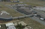
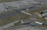
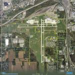
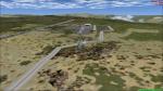
This scenery adds the new Cross Border Xpress (CBX) terminal to MMTJ, which opened on December 9, 2015, making it the first airport in the world to have connecting terminals in two different countries. All of MMTJ is also updated to reflect the most current airport layout. The neighboring KSDM is also completely updated and included in this scenery package. This scenery is optimized to fit seamlessly with FTX Global/Vector and also includes an optional CVX file which adds roads for default FSX users. All elements of both airports were traced directly from current satellite imagery and updated to reflect current satellite positioning. Scenery was created using Airport Design Editor X v1.61.5298, SBuilderX 3.13, and the FSX Object Placement Tool. Scenery objects were added and modified from stock FSX scenery to resemble as closely as possible the actual airports. The FSX apron lights included are from the set created by Jim Dhaenens.
Posted Jan 2, 2016 18:36 by Carlyle Sharpe
1.34Mb (354 downloads)
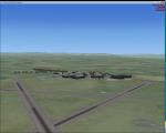
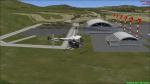
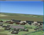
RAF Topcliffe (ICAO: EGXZ) is a Royal Air Force station in North Yorkshire, England. It is a satellite station serving in the role of a Relief Landing Ground for Tucano aircraft of the Central Flying School (CFS) based nearby at RAF Linton-on-Ouse (one of two, the other being Dishforth Airfield). As such, no RAF personnel are based permanently at the airfield and airfield services are provided by personnel assigned to RAF Linton-on-Ouse.
Topcliffe is also used by the Air Training Corps as a motor glider airfield for Gliding induction courses and Gliding scholarships
Posted Jan 1, 2016 04:28 by Terry Boissel
0.07Mb (530 downloads)
Bishop International Airport is a commercial and general aviation airport located in Flint, Michigan. Added assigned parking and removed runway 5-23 as it closed back in 2009 to save money.
Posted Dec 30, 2015 15:52 by Trevor Mead
16.72Mb (978 downloads)
P3D compatible
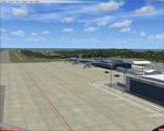
El Trompillo Airport (IATA: SRZ, ICAO: SLET) is located in the south part of Santa Cruz, Bolivia, about 2 km
(1.25 miles) away from the central plaza. Airport type:(Public / Military).
After a series of improvements, in June 3, 2014 Airport regained its status as an international airport by
converting to Santa Cruz de la Sierra in Bolivia the only city with two international airports, international
airport suitable as retention and/or support times of high demand in the Viru Viru Airport (ICAO: SLVR) can not
supply completely.
The airport resides at an elevation of 1,371 ft (418 m) above mean sea level. Have one runway designated 15/33 with an asphalt surface measuring 8,967 by 114.82 ft (2,733 m by 35 m) and is surrounded by hangars belonging to the Bolivian Air Force, as Aeroeste small Airlines, Ecojet, air taxis, especially aviation schools, and many others. Receives many aircraft daily, usually light training aircraft or military
aircraft. Among these aircraft is the Boeing 737-200, and BAe Xian MA60 Military Airlift, the BAe 146-200
of Ecojet and Cessna C152, C172, C206 and C210 of flying schools and air-taxis. The airport also operates civil
and military helicopter operations.
Posted Dec 28, 2015 17:23 by Marcos A. Rivas Torrez

9.32Mb (456 downloads)
P3D compatible
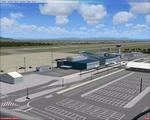
Ixiamas Airport (ICAO: SLIX) is a public use airport located near Ixiamas, La Paz, Bolivia.
The airport resides at an elevation of 725 ft (221 m) above mean sea level. It has one runway designated 18/36 with an asphalt surface measuring 7,874 by 98 ft (2,400 m by 30 m). This new airport is recently
operational since may,2015.Ixiamas Municipality is the first municipal section of the Abel Iturralde Province in the La Paz Department, Bolivia. The region is seat of Madidi Park, a natural reserve attractive to tourists in search of adventure.
Posted Dec 28, 2015 17:05 by Marcos A. Rivas Torrez
9.34Mb (432 downloads)
SL02 - Alcantari International - Sucre-Yamparaez - Bolivia scenery photoreal: (The little town of Alcantari an the little city of Yamparaez are Included in this package). The Alcantari International Airport is a new airport under construction in
Yamparaez municipality, Chuquisaca, Bolivia, around 35 Km to the south of Sucre City.
Posted Dec 28, 2015 08:25 by Marcos A. Rivas Torrez
13.07Mb (1384 downloads)
FSX Mt. Fuji Shizuoka Airport (RJNS), Japan. Ver1.00
Mount Fuji Shizuoka Airport is a Japanese local airport in Shizuoka Prefecture.
It was built at 2009 with a 2500m runway and is the nearest airport to Mt. Fuji.
This scenery was made mainly by Sketchup without Gmax. By Ushikoba
Posted Dec 28, 2015 07:42 by uploader
1.60Mb (339 downloads)
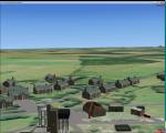
RAF Bircham Newton is a former Royal Air Force station located 2.1 miles (3.4 km) south east of Docking, Norfolk
and 13.4 miles (21.6 km) north east of King's Lynn, Norfolk, England.
The site was first used during the First World War and received the largest British bomber of the time, the Handley Page V/1500. They would have carried out bombing missions against Berlin but the Armistice was arranged before any missions were actually flown.
The airfield was equipped with one aircraft repair shed and three double bay general service sheds, although these had been demolished by 1937. It had two Belfast hangars, three C Type hangars, three Bellman hangars and ten Blister hangars.
It operated through the Second World War as part of No. 16 Group RAF as part of Coastal Command.
No. 206 Squadron RAF was one of the squadrons being based there, on maritime patrol duties. Two satellite airfields, RAF Docking and RAF Langham were opened to accommodate units.
In 1965 the airfield was used for evaluation trials of the Hawker Siddeley Kestrel V/STOL aircraft.
After closure as an operational airfield in 1966, the airfield became the home of the Construction Industry Training Board. The runways have gone, but the majority of buildings on the site, including some hangars and the control tower, remain in use by the CITB.The control tower was demolished in 2010 due to its poor condition.
Constructionarium is also based within the estate, providing a week's practical learning opportunity for undergraduates
Source: Wikipedia
Posted Dec 24, 2015 14:49 by Terry Boissel
12.65Mb (870 downloads)
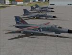
This is a upgrade to Australian RAAF Airbases Amberly and East Sales. It adds Military Combat and Cargo parking spots, New AI F-111C, F-111G and EF-111A aircraft,textures and flight plans. Each AI aircraft has its own tail number and is addressed by ATC with that tail number.
Installer has option to add AI aircraft only if you already have an add-on scenery package for these airbases.
Featuring John Young's AI F-111 version 2.0 models
Posted Dec 24, 2015 10:20 by Steve Hess

6.99Mb (1158 downloads)
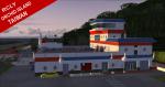
RCLY Lanyu Airport / Orchid Island, Taiwan. 3700FT Hard Runway lots of Details Night Lighting Island Located in the Western Pacific Ocean off the Coast of Taiwan. Very well rendered Airport Works with FSX Gold / Acceleration. Definetly worth having !Original Scenery designer by: Shigeru Tomino of Lets Fly Assoc.
Posted Dec 24, 2015 02:53 by Jetranger