


0.01Mb (204 downloads)
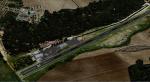
This scenery is merely a representation of RAF Spitalgate(formally RAF Grantham) and is only intended to add
another flying base for the many simmers out there who would like to fly to a different location once in a while.
The H & J Blocks are in the correct place as is the officers mess(I think) the rest is just placed to add flavour
of an RAF Unit.
The station opened in 1915 as Royal Flying Corps Station Grantham, becoming RAF Station Grantham on 1 April 1918 -
a name it bore until 1942 when it was renamed as RAF Station Spitalgate. Throughout the First World War the
station was a flying training facility and headquarters of No. 21 Group RFC Flying Training Command.
The station was an Officer Cadet Training Unit (OCTU) in the 1950s. Much later it became the Women's Royal Air
Force (WRAF) Depot, responsible for the recruitment and training of all non-commissioned females in the RAF, until
this moved to RAF Hereford and later again to RAF Swinderby. It was also the home of the Central Gliding School
which moved to RAF Syerston in March 1975.
In 1975 the RAF vacated the site and the following year it became a British Army base known as Prince William of
Gloucester Barracks
Posted Dec 7, 2015 21:10 by Terry Boissel
0.01Mb (220 downloads)
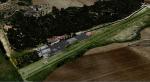
RAF Shepherds Grove is a former Royal Air Force station located 9.9 miles (15.9 km) north-east of Bury St Edmunds, Suffolk, England.
The Station was originally built for the United States Army Air Forces (USAAF) Eighth Air Force during the Second World War. However the facility was not used by the USAAF and was opened by No. 3 Group RAF on 3 April 1944. The name came from a small copse nearby and the airfield is close to Walsham le Willows in Suffolk.
It was occupied by No. 196 Squadron RAF in January 1945 as a base for Operation Varsity, supporting the Rhine crossing.
Various American units occupied the station after WW2 but ended their use of the unit in December 1958.
On 22 July 1956, No. 82 Squadron RAF was activated at Shepherds Grove as a Thor missile unit. Thor launching sites were built on the main airfield and became operational in 1959.
The base was closed in 1966.
Posted Dec 7, 2015 20:08 by Terry Boissel
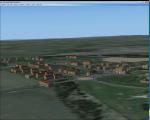
6.85Mb (275 downloads)
RAF West Raynham was situated 2 miles west of the village from where it got its name and was built as a part of the RAF expansion scheme. The Station opened
in May 1937 and was a bomber command unit throughout the Second World War. The Station closed in 1994.
I was Stationed at RAF West Raynham in the late eighties and that is the period that I have tried to re-create here.
I have given the Station the ICAO code of X3WR in line with other scenery developers who use Bones as a reference
Posted Dec 7, 2015 19:24 by Terry Boissel
0.03Mb (214 downloads)
RAF Strubby was located south east of the Lincolnshire Wolds town of Louth and south of the village from where the station got its name.
Opening in early 1944 the station lead a varied aircraft career being used by the USAAF as well as the RAF during the time it was operation. (For a more detailed history of the station the following web site is a wonderful source of information - www.bcar.org.uk/strubby-history. The station closed for Military flying in 1972. By Terry Boissel
Posted Dec 7, 2015 19:16 by Terry Boissel
0.01Mb (207 downloads)
RAF Stenigot was a Second World War radar station situated at Stenigot, near Donington on Bain, Lincolnshire.
It was part of the Chain Home radar network, intended to provide long range early warning for raids from
Luftflotte V and the northern elements of Luftflotte II along the approaches to Sheffield and Nottingham and the
central midlands.
After the Second World War, the site was retained as part of the Chain Home network. In 1959 it was upgraded to a
communications relay site as part of the ACE High program, which involved adding four tropospheric scatter dishes.
The site was decommissioned in the late 1980s and was mostly demolished by 1996.
The radar tower is a Grade II listed structure and is now used by the RAF Aerial Erector School for selection
tests for possible recruits.
There is a Memorial at the top to a former RAF Aerial Erector.
Souce: Wikipedia
Posted Dec 7, 2015 19:13 by Terry Boissel
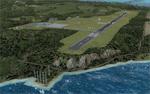
55.01Mb (1629 downloads)
FSX Massarotti (Caltagirone) Airfield, Catania, Scicily photoreal scenery. The airfield supports flight operations and skydiving and offers catering and accommodation.
Features: Massarotti Airfield has a grass or clay runway depending on the season. Documents included. Nunzio Caltabiano. Updated and fixed as some users reported crash.
Posted Dec 7, 2015 06:33 by Voyager
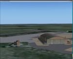
0.85Mb (616 downloads)
This update adds numerous visual details to the area around the airport as well as the addition of more roads to the island. Namely, the approach lights to runway 12 are corrected to appear on pylons and at runway elevation. This update requires "Rodrigues_Island.zip".
Required files:
required file
Posted Dec 7, 2015 03:14 by Carlyle Sharpe
1.27Mb (295 downloads)
Royal Air Force Ouston,is a former Royal Air Force station that was located near the village of Stamfordham and
the village of Heddon-on-the-Wall on Hadrian's Wall near Newcastle upon Tyne. The station opened on the 10 March
1941 and closed for flying in September 1974. As with many airfields the Army moved in and the station was re-
named Albemarle barracks.
If you would like the full history of the station or any other station in the North East I recommend you go to
the"North East Avation Research" website the link is:-
http://www.nelsam.org.uk/NEAR/Airfields/Histories/Ouston.htm
Posted Dec 6, 2015 19:06 by Terry Boissel
0.02Mb (284 downloads)
RAF Hibaldstow is a former Royal Air Force satellite airfield located south of Hibaldstow in Lincolnshire and 8.3 miles (13.4 km) south east of Scunthorpe, Lincolnshire, England.
The airfield was built with greater things in mind, but it only became a satellite airfield for RAF Kirton-in-Lindsey in 1941. When the runways were constructed, some of the hardcore was made from material taken from demolished bungalows on the site.
The airfield was commissioned on 12 May 1941 when No. 255 Squadron RAF took up residence with their Boulton Paul Defiant night fighters. These planes had been drawn from RAF Kirton-in-Lindsey and made one 'kill': an He 111 which was shot down near Louth on 5 June 1941.
In June 1941 the Defiants were replaced by Bristol Beaufighter IIFs and on 23 September 1941 No. 253 (Hyderabad) Squadron from RAF Skeabrea, Orkney, arrived. In addition Havocs from RAF Hunsdon in Hunsdon, Hertfordshire also came to the base.
By the start of 1943, the high risk of night attacks by the Luftwaffe led to the closure of the airfield on 23 January 1943. It re-opened on 9 May 1943 for No. 53 Operational Training Unit RAF (OTU) and once again closed on 15 May 1945. Shortly before closure WAAF Margaret Horton had an 'unexpected ride on the tail of a Supermarine Spitfire' while acting as a tailweight: she was sitting on the tail of the plane, as was common practice, in order to stop it overturning while it taxied to the end of the runway, a hazard stemming from design drawbacks, strong wind and bouncy grass field. The pilot, anxious to be airborne, forgot about her and failed to stop to allow the WAAF to jump off the tail. As soon as the plane was in the air, the pilot realised that there was something very wrong with the handling of his aircraft. He radioed the control tower to report the problem. The emergency services were called out and the pilot talked back in without being told what had happened. The aircraft landed safely with Margaret Horton still in one piece.
On 6 August 1947 the station finally closed and during 1960-61 it was sold off for use as agricultural land. It was also used for Sunday markets, as a skid-pan by Lincolnshire Police and by a local parachute club. The control tower was converted to a two-storey house in 1976.
Source Wikipedia
Posted Dec 6, 2015 18:29 by Terry Boissel
0.02Mb (240 downloads)
RAF Kirton in Lindsey was a Royal Air Force installation located 15 miles (24 km) north of Lincoln, Lincolnshire, England.
From the historical point of view, there is some uncertainty about the correct name of the location. Kirton Lindsey or Kirton-in-Lindsey?
It appears to have been an RAF habit (inherited from the RFC to name its bases after the nearest railway station, possibly to simplify the process of issuing Rail Warrants to personnel posted there. By that token, the site should be RAF Kirton Lindsey, Kirton Lindsey being the name of the nearby railway station constructed in 1849. No.255 Squadron's Operations Record Book (ORB) consistently uses that version of the name. So does the airfield's separate ORB, from the date of the site's WWII creation (15 May 1940) through to May 1941. After mid-1941 and the departure of No.255 Squadron, use of RAF Kirton-in-Lindsey. Kirton in Lindsey begins to appear in the site's own records - eventually dominating. By Terry Boissel
Posted Dec 6, 2015 14:31 by Terry Boissel