


All Files > Page 1309
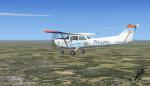
Cessna 172 PH-LPO Wolkentoetje Teuge Textures
(Category: FSX > Props)
13.05Mb (556 downloads)
This is an texture of the Cessna/Reims C172M PH-LPO Wolkentoetje of flying club Teuge (The Netherlands) This is an texture file only for the default FSX C172. Texture by: Mees Jansen
Posted Mar 8, 2014 10:40 by Mees Jansen
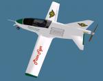
BD-5 Pizza Delivery Textures
(Category: FSX > Props)
2.48Mb (204 downloads)
Pizza delivery textures for the freeware BD-5 by Jez G. These textures can be used for both the prop and jet versions of the aircraft.
Required files:
required file
Posted Mar 8, 2014 09:52 by Pville211
F-16 Demopack vol.2 RNLAF Orange Lion Package
(Category: FSX > Military)
70.43Mb (2875 downloads)
This is the J-015 Soldisplay livery of the demo season 2012-2013 With the Kirk Ollson model included. This craft flies airshows to demonstrate where the dutch airforce is good for. This pack contains two livery of the J-015. Both in the dutch lion scheme. Original texture was for the Aerosoft F-16 made by Raymond Rotmans. Edited for the Kirk ollson F-16 by: Mees Jansen (LRI team) This pack also contains cool effects like afterburner, Smoke, And flares Kirk Ollson model included! Also includes the updated panel and VC by Danny Garnier.
Posted Mar 8, 2014 07:31 by Mees Jansen
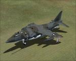
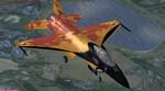
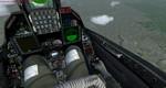
Harrier GR.3 / AV-8C Adapted for FSX (no VC)
(Category: FSX > Military)
65.68Mb (7713 downloads)
The Hawker Siddeley Harrier, known colloquially as the "Harrier Jump Jet", was developed in the 1960s and formed the first generation of the Harrier series of aircraft. It was the first operational close-support and reconnaissance fighter aircraft with vertical/short takeoff and landing (V/STOL) capabilities and the only truly successful V/STOL design of the many that arose in that era. The Harrier was produced directly from the Hawker Siddeley Kestrel prototypes following the cancellation of a more advanced supersonic aircraft, the Hawker Siddeley P.1154. The British Royal Air Force (RAF) ordered the Harrier GR.1 and GR.3 variants in the late 1960s. It was exported to the United States as the AV-8A, for use by the US Marine Corps (USMC), in the 1970s. 2d panel only. No VC (press F10 to see 2d panel)
Posted Mar 7, 2014 18:20 by Mohammad Faali
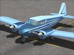
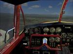
Piper PA-23 Apache Package
(Category: FSX > Props)
47.97Mb (8152 downloads)
FSX Lynn and Bill Lyons' PA23 Piper Apache updated and adapted for FSX. Includes four liveries with companion, color-coded panel sets.
Each panel set is distinctively gauged with complementary 2D and VC views. Special thanks to Milton Shupe and Scott Thomas
for Scott's period gauges and to Aaron R. Swindle for his "Big Twin" sound package.
This is KENWIGAIR KUSTOMS' RESTO-MOD #1. By Ken Wigginton.
Posted Mar 7, 2014 02:25 by uploader
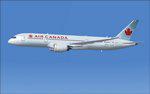
Air Canada first Boeing 787-8 C-GHPQ
(Category: FSX > Civil Jets)
5.67Mb (4789 downloads)
FSX Air Canada first Boeing 787-8, C-GHPQ. This version 5, features more improved and detailed aircraft model and textures , including CamSim's own static displays and Animated Ground Servicing (AGS). 2d panel but no VC.
Model design and paint by Camil Valiquette
Posted Mar 7, 2014 02:00 by camil valiquette
Air Canada first Boeing 787-8 C-GHPQ
(Category: FS2004 > Civil Jets)
3.98Mb (1111 downloads)
FS2004 Air Canada first Boeing 787-8, C-GHPQ. This version 5, features more improved and detailed aircraft model and textures , including CamSim's own static displays and Animated Ground Servicing (AGS).
Model design and paint by Camil Valiquette.
Posted Mar 7, 2014 01:47 by camil valiquette
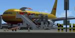
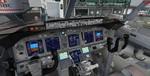
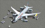
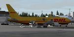
Boeing 767-3JHF/ER WL DHL "Panda Pairi Daiza" with Advanced VC
(Category: FSX > Civil Jets)
61.56Mb (6458 downloads)
SkySpirit2010 - Boeing 767-3JHF/ER WL DHL "Panda Pairi Daiza" with VC for FSX
FSX model by Skyspirit
with advanced 737-800 VC added. Includes utility for ground services, cargo, stairs, etc (find it under - Views - Instrument panel - Posky Utility)
The wonderful creation from Project Opensky will be enjoyed by many more people who do not know how to install a VC, views, exits, Utilities etc into a FSX native model. So now this 767-300 has the nearest VC I can find -- the 737-800. The layout fof the 767 cockpit is not a million miles away from the advanced 737-800.
The VC is the Alejandro Rojas Lucena/FSND fantastic revised Boeing 737-800 VC model. This VC model includes Working wipers (right mouse click on switch) with rain effect. Switches for LCD Screens, EICAS, PFD, MFT. Autobrake switch. Opening pilots window. Cabin Lights switch. Realistic FMC. Ground Proximity Warning System (GPWS), More Realistic night VC textures. There are custom Boeing sounds included for that extra realism.
I have used the fantastic DHL "Panda Pairi Daiza" textures by Stefan Bree / FSRepaintsGER.
Also added 767 sounds for more realism. Also added 767-300 exits cfgs so jetways can be used (Ctrl J)
Model is not modified in any way. Just the VC added and aircraft.cfg edited to allow correct VC views.
Skyspirit wonderful native FSX Boeing 767-300 model. See VC docs to get the best out of the VC and FMC.
Prepared and assembled for FSX by Chris Evans.
Posted Mar 6, 2014 13:09 by chris evans
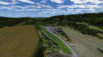
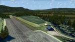
Grassfields of Norway Package
(Category: FSX > Scenery)
324.30Mb (879 downloads)
Grassfields of Norway (GFoN),
adds quite a few missing Norwegian grassfields. The first edition, v1.0, adds 8 grassfields. ENKE Kjellstad, ENHY Huseby, ENEB Eidsberg, ENRT Ruteig, ENVM Veum, ENLE Lier, ENEE Egge & ENTN Torsnes. By Marius Risan. Zip file preview for preview images.
Posted Mar 6, 2014 12:36 by uploader
Boeing 767-300ER V5, DHL "Panda Pairi Daiza"
(Category: FS2004 > Civil Jets)
12.12Mb (2261 downloads)
SkySpirit2010 Boeing 767-300ER V5, DHL "Panda Pairi Daiza", G-DHLG. Full model included. Textures by Stefan Bree / FSRepaintsGER
Posted Mar 6, 2014 10:32 by chris E