


All Files > Page 1353
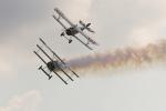
Nose Gun Effects
(Category: FSX > Misc)
0.04Mb (966 downloads)
While there are plenty of *wing gun effects, If you're really looking for a First World War fighter with nose gun effects, simply download this package and read the enclosed instructions! -TheHawkerHurricaneMan
Posted Dec 13, 2013 20:19 by TheHawkerHurricaneMan

FSX Douglas C-47 Buffalo Airways Textures
(Category: FSX > Vintage)
18.20Mb (2231 downloads)
Repaint for the C-47 V2 Manfred's Jahn and team. Repaint included the exterior and interior (virtual cockpit) for the Buffalo Airways C-GPNR DC-3 airplane, repaint by Hani Michal.
Required files:
required file
Posted Dec 12, 2013 20:24 by Hani Michal
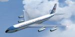
FSX Boeing 707 package
(Category: FSX > Civil Jets)
66.09Mb (11448 downloads)
Boeing 707 in several liveries: BOAC, Air Force One, Air France, Lufthansa, Panam, TWA, Singapore Airlines by Libardo Guzman. VC modification, new gauges, 4/3 and 16/9 panels, GPWS callout by Philippe Wallaert. See instructions in the readme.txt file.
Posted Dec 12, 2013 11:53 by Philippe Wallaert
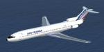
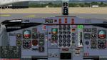
FSX Boeing 727-200 Air France
(Category: FSX > Civil Jets)
13.98Mb (6882 downloads)
The 727 is one of the most popular aircraft ever built: 1831 units delivered, launched in 1963 and still in service! Original aircraft by FSFRANCE. Adaptation to FSX, 4/3 and 16/9 panels (no VC) by Philippe Wallaert.
Posted Dec 12, 2013 04:19 by Philippe Wallaert
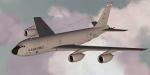
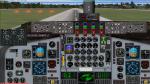
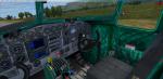
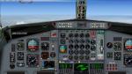
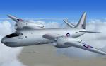
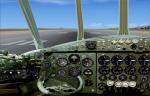
FSX Boeing KC-135 R Stratotanker
(Category: FSX > Military)
10.43Mb (7735 downloads)
The KC 135 is similar to the 707. It was launched in 1957 and 803 units were produced. The KC 135 R version is equipped with CFM56 engines. Original aircraft by PAD, VC adaptation, 2D panels for wide and standard screen by Philippe Wallaert. See instructions in the readme.txt file.
Posted Dec 12, 2013 03:35 by Philippe Wallaert
.jpg-thumb.jpg)
.jpg-thumb.jpg)
FSX Pilotable IJN Seaplane Tender Nisshin
(Category: FSX > Misc)
2.68Mb (716 downloads)
FSX pilotable seaplane tender Nisshin, a ship from WWII. This FS-model is a very detailed CFS2 IJN warship made by Usio no Ibuki in a high quality. My AddOn is conferted to FSX and provides a pilotable ship with 2D panel as navigation bridge and two VC-cameras. Eighteen other cameras allows you to explore the ship, including the options to set an Aichi Jake floatplane onto the catapult. Included are artillerie-, AA-gun- and general ship-effects. Bitmaps and configuration by Erwin Welker
Posted Dec 12, 2013 02:53 by Erwin Welker
.jpg-thumb.jpg)
.jpg-thumb.jpg)
FSX Pilotable Torpedo Boat Destroyer USS Cole (fixed)
(Category: FSX > Misc)
2.18Mb (932 downloads)
(fixed) FSX Pilotable torpedo boat destroyer USS Cole. This fast ship was in service from 1919 until 1945. The FS-model is a very detailed CFS2-model in a high quality, made by Usio no Ibuki. Now it is converted to FSX and provides even virtual decks views. My AddOn provides a pilotable ship with 2D panel as navigation bridge and four VC-cameras. Fourteen other cameras allows you to explore the ship, including the options to swivel both of the quadruple torpedolaunchers. Included are gun-, torpdo-, depth charches- and general ship-effects. Bitmaps and configuration by Erwin Welker
Posted Dec 11, 2013 17:32 by Erwin Welker

Descent Distance Calculator v1.0
(Category: FSX > Utilities)
0.29Mb (2592 downloads)
A simple application calculating the climb/descent distance by using the airspeed as a constant value. Does not require FSX installed on the same PC. Results may not work for other flight simulators.
Posted Dec 11, 2013 12:52 by dave_h
FSX Short Sperrin update
(Category: FSX > Vintage)
11.85Mb (1644 downloads)
The Short S.A.4 was a British jet bomber design of the early 1950s. The package features FSX compatible gauges, a new basic VC with non-functioning gauges, added smoke effects and corrected contact points.Model by Kazunori Ito, updated for FSX by Michael Pook
Posted Dec 11, 2013 09:28 by Michael Pook
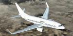
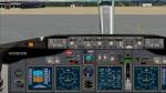
FSX Boeing 737 BBJ U.S. AIR FORCE
(Category: FSX > Civil Jets)
8.14Mb (2765 downloads)
The 737 BBJ is based on the 737-800 and has a longest range. Original aircraft by GPLANES, repaint, adaptation to FSX, wide screen panel (no VC), callouts by Philippe Wallaert. See instructions in the readme.txt file.
Posted Dec 11, 2013 04:53 by Philippe Wallaert