


All Files > Page 1712

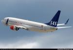
Boeing 737-800 SAS Braathens Texture
(Category: FSX > Civil Jets)
7.78Mb (1554 downloads)
SAS Braathens textures for the default Boeing 737-800.
By henrik i.l
Posted May 1, 2012 14:21 by Henrik i.l
FS2004 TUIfly Boeing 737-800 ÜBÄRflieger
(Category: FS2004 > Civil Jets)
(1062 downloads)
FS2004 TUIfly Boeing 737-800WL in Bärenmarke / ÜBÄRflieger livery, registration D-AHFR. Highly detailed 32 bit textures. New photorealistic window textures and night textures. Model by Project Open Sky (Posky) is included. By FSRepaintsGER / Benjamin Spranger.
Posted May 1, 2012 11:55 by FSRepaintsGER / Benjamin Spranger
Jet City MD-83 "ARG" Textures
(Category: FS2004 > Payware)
5.89Mb (46 downloads)
MD-83 "ARG" textures only for the payware JetCity MD-83. . FICTITIOUS REPAINT BECAUSE "ARG" DON'T OPERATE THIS AIRCRAFT. TEXTURES ONLY FOR "JET CITY AIRCRAFT" MODEL.
Posted May 1, 2012 11:41 by LUIS CASTRO
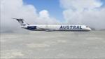
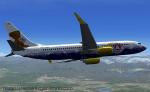
Jet City MD 83 Austral Lineas Aereas Textures
(Category: FS2004 > Payware)
4.28Mb (457 downloads)
MD 83 Austral Lineas Aereas textures only for the payware Jetcity MD83
Posted May 1, 2012 11:34 by LUIS CASTRO
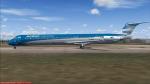
MD 83 Aerolineas Argentinas Textures
(Category: FS2004 > Payware)
5.25Mb (716 downloads)
MD 83 Aerolineas Argentinas textures for ther payware Jetcity MD83.
Posted May 1, 2012 11:29 by LUIS CASTRO
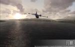
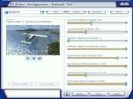
FSWC Real Water
(Category: FSX > Scenery)
3.32Mb (6014 downloads)
FS Water Configurator is a freeware addon utility for Microsoft Flight Simulator X designed to modify the look of the reflective water in the game. It will increase the realism of the reflections and lighting of the water and is completely controllable by the user. If you prefer glass like reflections or very subtle water reflections, FSWC is the utility for you.
Official site (below)
Posted May 1, 2012 11:17 by ricardo_tv
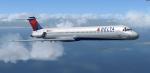
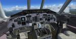
Delta Airlines New Colors MD-88 Package
(Category: FSX > Civil Jets)
70.55Mb (17512 downloads)
Delta Airlines MD-88 with model, panel,
textures, soundsets (custom made and realistic), radar for multiplayer/singleplayer, and more realistic dynamics. This is a simple aircraft, even though it has a safisticated panel, no FMC/ONS system is included in this aircraft, so you have to use the GPS system that is installed in the panel. This aircraft is really a beauty to fly, and I hope that you all fly it until you just cant fly it no more.
Thanks to Mitsushi Yutaka for the excellent aircraft with the vc man! you rock and I've been a fan of you since fs2002. Uses custom MD88 sounds.
Posted May 1, 2012 07:43 by uploader

US Airways Boeing 767-2B7/ER N655US
(Category: FS2004 > Civil Jets)
20.19Mb (2043 downloads)
US Airways Boeing 767-2B7/ER N655US. SkySpirit2010 767-200 v5. Model features High resolution textures, Dynamic flexing wings, Nose gear steering, Rudder lock, Ground spoilers, Low speed aileron locks at high speed, Fully animated control surfaces, Fully independent suspension, Trim Animation, Opening Passenger Doors, Animated tilting bogies, Rolling wheels, Animated thrust reverser's with reverser block doors, Detailed textures, Full night lighting, Crash affects, Ground Service Vehicles And more. Model Designer Hiroshi Igami/Yosuke Ube. Flight Dynamics Designer Warren C. Daniel. Textures by Philip Foglar. Livery by Philip Foglar.
Posted May 1, 2012 07:13 by uploader
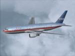
USAir Boeing 767-2B7/ER N655US
(Category: FS2004 > Civil Jets)
21.21Mb (1023 downloads)
USAir Boeing 767-2B7/ER N655US. SkySpirit2010 767-200 v5. Model features High resolution textures, Dynamic flexing wings, Nose gear steering, Rudder lock, Ground spoilers, Low speed aileron locks at high speed, Fully animated control surfaces, Fully independent suspension, Trim Animation, Opening Passenger Doors, Animated tilting bogies, Rolling wheels, Animated thrust reverser's with reverser block doors, Detailed textures, Full night lighting, Crash affects, Ground Service Vehicles And more. Model Designer Hiroshi Igami/Yosuke Ube. Flight Dynamics Designer Warren C. Daniel. Textures by Philip Foglar. Livery by Philip Foglar.
Posted May 1, 2012 07:11 by uploader
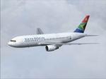
South African Airways NC Boeing 767-266/ER ZS-SRB
(Category: FS2004 > Civil Jets)
18.96Mb (1936 downloads)
South African Airways NC Boeing 767-266/ER ZS-SRB. SkySpirit2010 767-200 v5. Model features High resolution textures, Dynamic flexing wings, Nose gear steering, Rudder lock, Ground spoilers, Low speed aileron locks at high speed, Fully animated control surfaces, Fully independent suspension, Trim Animation, Opening Passenger Doors, Animated tilting bogies, Rolling wheels, Animated thrust reverser's with reverser block doors, Detailed textures, Full night lighting, Crash affects, Ground Service Vehicles And more. Model Designer Hiroshi Igami/Yosuke Ube. Flight Dynamics Designer Warren C. Daniel. Textures by Philip Foglar. Livery by Philip Foglar.
Posted May 1, 2012 06:50 by uploader