


All Files > Page 1929
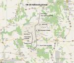
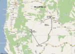
FS2004 Flight Plan for OB-20 Holbrook Arizona
(Category: FS Navigation > Flight Simulator Navigation)
0.38Mb (79 downloads)
FS2004 Flight Plan for OB-20 Holbrook Arizona IFR high speed low altitude military training route. This is the eighth in a series of FS2004 flight plans I have uploaded. This route goes through mostly flat and rolling terrain in Colorado, Utah, And Arizona. These are great routes for B-52, F-111, B-1B, B-2 A6, A4, Vulcan and any fighter or bomber enthusiasts. Of course you can fly the route with any aircraft of your choice. Included in this package is a gauge by Karol Chlebowski for TFR flying at very low altitude. This gauge will greatly enhance your ability to fly these challenging routes and is a great companion of the flight plans. Another option to download Version 2.0 of my FS2004 mini panel which has all this functionality and more.
Posted Jul 27, 2011 22:23 by Bill McClellan
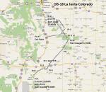
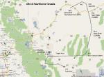
FS2004 Flight Plan for OB-18 Junta Colorado
(Category: FS Navigation > Flight Simulator Navigation)
0.32Mb (83 downloads)
FS2004 Flight Plan for OB-18 Junta Colorado IFR high speed low altitude military training route. This is the seventh in a series of FS2004 flight plans I have uploaded. This route goes through flat and rolling terrain in New Mexico, Texas, Oklahoma, and Colorado. These are great routes for B-52, F-111, B-1B, B-2 A6, A4, Vulcan and any fighter or bomber enthusiasts. Of course you can fly the route with any aircraft of your choice. Included in this package is a gauge by Karol Chlebowski for TFR flying at very low altitude. This gauge will greatly enhance your ability to fly these challenging routes and is a great companion of the flight plans. Another option to download Version 2.0 of my FS2004 mini panel which has all this functionality and more.
Posted Jul 27, 2011 22:21 by Bill McClellan
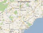
FS2004 Flight Plan for OB-17 Statesboro Georgia
(Category: FS Navigation > Flight Simulator Navigation)
0.44Mb (73 downloads)
FS2004 Flight Plan for OB-17 Statesboro Georgia IFR high speed low altitude military training route. through flat and rolling terrain in North Carolina, South Carolina and Georgia This is the sixth in a series of flight plans I have uploaded. These are great routes for B-52, F-111, B-1B, B-2 A6, A4, Vulcan and any fighter or bomber enthusiasts. Of course you can fly the route with any aircraft of your choice. Included in this package is a gauge by Karol Chlebowski for TFR flying at very low altitude. This gauge will greatly enhance your ability to fly these challenging routes and is a great companion of the flight plans. Another option to download Version 2.0 of my FS2004 mini panel which has all this functionality and more.
Posted Jul 27, 2011 22:20 by Bill McClellan
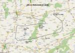
FS2004 Flight Plan for OB-11 Richmond KY (Old)
(Category: FS Navigation > Flight Simulator Navigation)
0.09Mb (53 downloads)
FS2004 Flight Plan for OB-11 Richmond KY (Old) IFR high speed low altitude military training route. This is the fifth in a series of flight plans I have uploaded. These are great routes for B-52, F-111, B-1B, B-2 A6, A4, Vulcan and any fighter or bomber enthusiasts. Of course you can fly the route with any aircraft of your choice. Included in this package is a gauge by Karol Chlebowski for TFR flying at very low altitude. This gauge will greatly enhance your ability to fly these challenging routes and is a great companion of the flight plans. Another option to download Version 2.0 of my FS2004 mini panel which has all this functionality and more.
Posted Jul 27, 2011 22:18 by Bill McClellan
-1.jpg-thumb.jpg)
FS2004 Flight Plan for OB-11 Richmond Kentucky
(Category: FS Navigation > Flight Simulator Navigation)
0.36Mb (62 downloads)
FS2004 Flight Plan for OB-11 Richmond Kentucky IFR high speed low altitude military training route. This route goes through mountainous terrain in Tennessee, North Carolina, Virginia and Kentucky. This is the fourth in a series of flight plans I have uploaded. These are great routes for B-52, F-111, B-1B, B-2 A6, A4, Vulcan and any fighter or bomber enthusiasts. Of course you can fly the route with any aircraft of your choice. Included in this package is a gauge by Karol Chlebowski for TFR flying at very low altitude. This gauge will greatly enhance your ability to fly these challenging routes and is a great companion of the flight plans. Another option to download Version 2.0 of my FS2004 mini panel which has all this functionality and more.
Posted Jul 27, 2011 22:17 by Bill McClellan
FS2004 Flight Plan for OB-10 Hawthorne Nevada
(Category: FS Navigation > Flight Simulator Navigation)
0.31Mb (73 downloads)
FS2004 Flight Plan for OB-10 Hawthorne Nevada IFR high speed low altitude military training route. This is the third in a series of flight plans I have uploaded . This route goes through both mountainous and flat and rolling terrain in California, and Nevada. These are great routes for B-52, F-111, B-1B, B-2 A6, A4, Vulcan and any fighter or bomber enthusiasts. Of course you can fly the route with any aircraft of your choice. Included in this package is a gauges by Karol Chlebowski for TFR flying at very low altitude. This gauge will greatly enhance your ability to fly these challenging routes and is a great companion of the flight plans. Another option to download Version 2.0 of my FS2004 mini panel which has all this functionality and more.
Posted Jul 27, 2011 22:15 by Bill McClellan
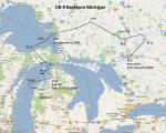
FS2004 Flight Plan for OB-9 Bayshore Michigan
(Category: FS Navigation > Flight Simulator Navigation)
0.45Mb (82 downloads)
FS2004 Flight Plan for OB-9 Bayshore Michigan IFR high speed low altitude military training route. This is the second in a series of flight plans I have uploaded. This route goes through flat and rolling terrain and over water in Ontario and Michigan. These are great routes for B-52, F-111, B-1B, B-2 A6, A4, Vulcan and any fighter or bomber enthusiasts. Of course you can fly the route with any aircraft of your choice. Included in this package is a gauge by Karol Chlebowski for TFR flying at very low altitude. This gauge will greatly enhance your ability to fly these challenging routes and is a great companion of the flight plans. Another option to download Version 2.0 of my FS2004 mini panel which has all this functionality and more.
Posted Jul 27, 2011 22:14 by Bill McClellan
FS2004 Flight Plan for OB-1 Wilder Idaho
(Category: FS Navigation > Flight Simulator Navigation)
0.30Mb (67 downloads)
FS2004 Flight Plan for OB-1 Wilder Idaho IFR high speed low altitude military training route through mountainous terrain in Oregon, Nevada and Idaho. This is the first in a series of FS2004 flight plans I will upload. These are great routes for B-52, F-111, B-1B, B-2 A6, A4, Vulcan and any fighter or bomber enthusiasts. Of course you can fly the route with any aircraft of your choice. Included in this package is a gauge by Karol Chlebowski for TFR flying at very low altitude. This gauge will greatly enhance your ability to fly these challenging routes and is a great companion of the flight plans. Another option to download Version 2.0 of my FS2004 mini panel which has all this functionality and more.
Posted Jul 27, 2011 22:12 by Bill McClellan

FSX Force Texture Fix
(Category: FSX > Military)
4.79Mb (457 downloads)
This is a replacement for the left and right wing pilots because of the unavailability of the pilots
Required files:
required file
Posted Jul 27, 2011 19:34 by FSX Force

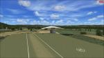
FSX Eferding Airfield, Austria
(Category: FSX > Scenery)
0.00Mb (731 downloads)
The Eferding Airfield in Austria doesn't exist in FSX! That's the reason why I've made it. Wels, Vrsar and Linz Airport are my next big projects! There will be some updates soon. This scenery is only for FSX! Please watch my youtube Channel: http://www.youtube.com/user/FSAG007?feature=mhee
Posted Jul 27, 2011 15:47 by Alex Grünwald