


All Files > Page 4319
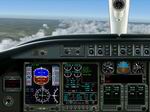
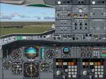
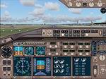
FS2004
Lear 45 Panel
(Category: FS2004 > Panels)
2.92Mb (5236 downloads)
FS2004
Lear 45 Panel.
By Ken Mitchell. 3MB
Posted Jun 23, 2008 14:26 by archive
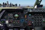
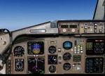
FS2004 Falcon 2000 Panel
(Category: FS2004 > Panels)
3.08Mb (2539 downloads)
FS2004
Falcon 2000 Panel. Ideal for Mike Stone's Falcon 2000 (see 'required file).
By Ken Mitchell. 3MB
Required files:
required file
Posted Jun 23, 2008 14:26 by archive
FS2004 Lockheed L1011 Tristar panel
(Category: FS2004 > Panels)
5.17Mb (5529 downloads)
FS2004
Lockheed L1011 Tristar panel
. PhotoTex Pro series panel from real pictures. It is tested
with WinXP, Win98 and FS2002. No need for FSUIPC. By Chris Alevritis.
5.3MB Required Concorde Gauge- here
Required files:
required file
Posted Jun 23, 2008 14:26 by archive
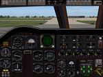
FS2004
C-130 Hercules Panel.
(Category: FS2004 > Panels)
3.26Mb (8428 downloads)
FS2004
C-130 Hercules Panel.
Designed with Mike Stone's C-130's & repaints in mind but
can be used with any C-130. By Ken Mitchell. 3.2MB
Posted Jun 23, 2008 14:26 by archive
FS2004
Airbus A300 B4-2C panel by Benoit Gaurant version 3.0. Aircraft
included
(Category: FS2004 > Panels)
5.32Mb (15513 downloads)
FS2004
Airbus A300 B4-2C panel by Benoit Gaurant version 3.0. Aircraft
included
- Air France ^ Air Inter. All gauges are new original ones with
real A300 B warning sounds. With Franck Weiss reworked fly dynamics.
Especialy tuned to work with SGA plane associated with the aircraft.cfg
and .air files included in this archive. Connection between
AP and CIVA IV INS v1.2 CIVA IV INS v1.2 needed not included.
See read me and documentation files. Made with Air Inter photographs
and documentation. 5.4MB
Posted Jun 23, 2008 14:26 by archive
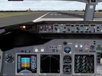
FS2004
Boeing 737-NG Panel.
(Category: FS2004 > Panels)
4.35Mb (7133 downloads)
FS2004
Boeing 737-NG Panel.
Created using original photorealistc bitmaps for main cockpit,pedestal
and overhead panel. Complete with Hud and alternate glass cockpit
configuration for PFD, ND and EICAS. The panel uses default
and third party gauges made by various authors. Panel by Marco
Spada. 4.4MB
Posted Jun 23, 2008 14:26 by archive
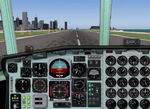
FS2004 Boeing 767 Panel.
(Category: FS2004 > Panels)
8.74Mb (8243 downloads)
FS2004
Boeing 767 Panel.
Real 3d effects,shadow effects,rear,and all ather view,upper
panel,fleps panel,radio panel,visual approach panel, look the
pictures. Requires Concorde gauge to
Chris JEANNE for the gauges MASSIMO GRASSI. 8.9MB
Required files:
required file
Posted Jun 23, 2008 14:26 by archive
FS2004
B-52 Stratofortress Panel
(Category: FS2004 > Panels)
3.96Mb (25719 downloads)
FS2004
B-52 Stratofortress Panel.
This panel was made for the Boeing B52 Stratofortress aircraft
made by Yaetsu Yoshimitsu / Hiroaki Kubota.Ken Mitchell. 4MB
Posted Jun 23, 2008 14:26 by archive
FS2004
Modified Boeing 777 Panel.
(Category: FS2004 > Panels)
0.31Mb (6150 downloads)
FS2004
Modified Boeing 777 Panel.
This is my first cockpit work. it's a modification of the default
777-3000 panel. I've put in 3 MFD's as well as the radio stack
all in one window. Also, you have the ability to control all
lights. . By: Alex Ramos. 321K
Posted Jun 23, 2008 14:26 by archive
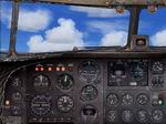
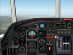
FS2004
Douglas DC-3 Reworked Panel
(Category: FS2004 > Panels)
1.65Mb (3022 downloads)
FS2004
Douglas DC-3 Reworked Panel.
This is the default panel with a little change to it. I put
in the default Boeing 747-400 heading, altitude and VSI windows.
Also added the 747-400 Approach and Backcourse buttons for ILS
landings and the Altitude hold button. Originals by Microsoft.
Changes by Carlo van Erp. 1.7 MB
Posted Jun 23, 2008 14:26 by archive