


All Files > Page 2196
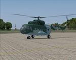
Mil Mi8 Croatian Air Force textures
(Category: FS2004 > Helicopters)
3.89Mb (1214 downloads)
Mil Mi8 Croatian Air Force textures for the Vladimir Zhyhulskiy Mi8 model. Repaint by Zsolt Beleznay.
Posted Aug 4, 2010 10:22 by Zsolt Beleznay
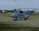
Mil Mi8 Lithuanian Air Force textures
(Category: FS2004 > Helicopters)
4.70Mb (928 downloads)
Mil Mi8 Lithuanian Air Force textures for the Vladimir Zhyhulskiy Mi8 model. Repaint by Zsolt Beleznay.
Posted Aug 4, 2010 10:20 by Zsolt Beleznay
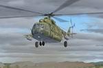
Mil Mi8 Hungarian Air Force textures
(Category: FS2004 > Helicopters)
5.66Mb (804 downloads)
Mil Mi8 Hungarian Air Force textures for the Vladimir Zhyhulskiy Mi8 model. Repaint by Zsolt Beleznay.
Posted Aug 4, 2010 10:19 by Zsolt Beleznay
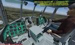
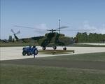
Mi-8MT Hip Package
(Category: FS2004 > Helicopters)
75.39Mb (12922 downloads)
7 of versions of the Mi8 model, 8 textures, completely reworked with 2D and 3D cabins. Created by Vladimir Zhyhulskiy
Posted Aug 3, 2010 17:35 by Vladimir Zhyhulskiy
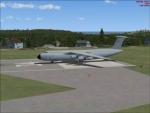
C-5M Super Galaxy Canadian Air Force
(Category: FSX > Military)
(4159 downloads)
C-5M Super Galaxy Canadian Air Force. FS2004 Model by Mike Stone updated for FSX -- 2d panel but no VC. Textures by Michael White. Sound Pack by Mike Hambly . Flight Dynamics and Data by Douglas E. Trapp.
Posted Aug 3, 2010 15:20 by Douglas Trapp
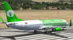
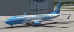
FSX Boeing 737-800 Default Airlines Livery Makeover Set 3
(Category: FSX > Civil Jets)
17.36Mb (2705 downloads)
The third set of new repaints for the FSX default airlines. (Microsoft's default paint schemes are dull, to say the least). This set is an Emeral Harbor Air "Sparkling Stone" livery and a Global Freightways "Solid Steel" livery. Both feature new scratch-built airline logos as well. Repainted by Adrian Monk.
Posted Aug 2, 2010 20:24 by Adrian Monk
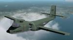
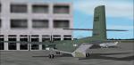
FS2002/2004 Marine DeHavilland C7 Textures
(Category: FS2004 > Military)
0.12Mb (884 downloads)
Repaint textures for Mike Stone's C7 depicting an aircraft used by the U.S. Marine Corps. Repaint by Don Brynelsen
Required files:
required file
Posted Aug 2, 2010 12:40 by Don Brynelsen
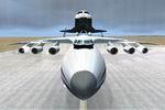
AN225 Splash Screen.
(Category: FSX > Civil Jets)
0.84Mb (4573 downloads)
AN225 Splash Screen.
Posted Aug 2, 2010 05:46 by lachlan macartney
Aerodromo San Carlos, Nicaragua
(Category: FS2004 > Scenery)
0.00Mb (393 downloads)
San Carlos Aerodromo in Rio San Juan,
Nicaragua.
Posted Aug 1, 2010 22:28 by Alberto Thomas
Cancun Airport, Mexico
(Category: FS2004 > Scenery)
0.00Mb (1681 downloads)
Cancun - Mexico, with the new airport runway.
Posted Aug 1, 2010 20:30 by Alberto Thomas