


All Files > Page 1448
KLGB - Long Beach Airport ( Daugherty Field )
(Category: FSX > Scenery)
0.02Mb (655 downloads)
This Airport was updated by Google Maps and Airport Diagram. Adds lots of new Parking Spots and Runway Fixes. Place in Microsoft Flight Simulator X > Addon Scenery > Scenery Folder and restart you FSX! Does Not Impact Frame Rates.
Posted Jun 30, 2013 05:13 by Delta2585
KLFT - Lafayette Regional Airport ; Lafayette, LA
(Category: FSX > Scenery)
0.01Mb (508 downloads)
This Airport was updated by Google Maps and Airport Diagram. Adds lots of new Parking Spots and Runway Fixes. Also added new ILS on Runway 04R. Place in Microsoft Flight Simulator X > Addon Scenery > Scenery Folder and restart you FSX! Does not impact Frame Rates.
Posted Jun 30, 2013 05:01 by Delta2585
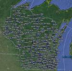
FSX Wisconsin Airfield Locator
(Category: FS Navigation > Flight Simulator Navigation)
2.57Mb (104 downloads)
Tested on Windows XP and Windows 7.
This download adds airfield markers and ICAO id's found in FSX, and overlays them on Google Earth.
This file is for Wisconsin. USA.
There is also a seperate file with a list of basic airfield location details.
i.e: EGBB Birmingham Airport. Birmingham. N52* 27.23' W1* 44.88' alt325.
Also the tidying "My places" in Google Earth, file.
Other locator files to follow.
by Carl Vokes
Posted Jun 29, 2013 15:39 by carl vokes
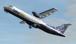
InterSky ATR 72-600 (72-121A) - OE-LIB
(Category: FS2004 > Props)
6.96Mb (2675 downloads)
This is a repaint of the excellent ISDT ATR72-200, in InterSky livery, OE-LIB. The textures are saved in 32-bit format for quality graphics. Model included.
Posted Jun 29, 2013 13:07 by Stefan Bree / FSRepaintsGER, ISDT
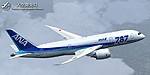
FS2004/FSX ANA Boeing 787-8
(Category: FS2004 > Civil Jets)
16.40Mb (4255 downloads)
FS2004/FSX ANA Boeing 787-8. A Boeing 787-8 in All Nippon Airways typical livery, registration JA807A, developed by Tenkuu Developers Studio (TDS). Model features high resolution textures, dynamic flexing wings, body gear steering, nose gear steering, rudder lock, ground spoilers, low speed aileron locks at high speed, fully animated control surfaces, fully independent suspension, trim animation, opening passenger doors, animated tilting bogies, rolling wheels, animated thrust reversers with reverser block doors, detailed textures, full night lighting, ground service vehicles and more. (No VC) Model design by Hiroshi Igami/Yosuke Ube. Flight dynamics design by Maurino M-Bezel Brown, Nick Wilkinson. Master textures by Yosuke Ube. Livery by Yosuke Ube.
Posted Jun 29, 2013 12:25 by uploader
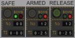
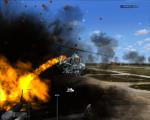
Bomb Ripple Switch for Helicopters Version 2
(Category: FSX > Military)
3.47Mb (2040 downloads)
FSX PROGRAMMABLE RIPPLE BOMB RELEASE SWITCH - VERSION 2-ADDED READOUT DISPLAY - For Droppable Objects.
****" Enables multiple bombs to be dropped at a SINGLE click ".****
This version is for Helicopters only, DO NOT use on Fixed wing aircraft.
Assign TAILHOOK to a Controller button to maximise useage.
(1) Set Number of Missiles/Bombs required, Qty "No" 01 to 99. (2) Set Time Interval required between each bomb ,"TI" 0.00 to 9.99 seconds.
(3) then a SINGLE Click of release "Pickle" button sets off the Ripple drop that you have set .Eg; "No 12 - TI 0.01" = concentrated drop zone. While "No 24 - TI 0.50" = strung out drop pattern, it will take 12 seconds for all 24 bombs to drop from your Helicopter.All from a Single click.
MUST have the freeware "Weapons Package" by Chris Sykes installed.
Has Safe - Armed lights ,Ideal for any military Helicopter Gunship , the Weapons used is totally up to individual preferences , generally it would be missiles like the Maverick or Hellfire , if you chose to drop multiple bombs , then make sure that you have a good forward speed to create separation between the ground impacts.Works for both Bombs and Missiles.Distance interval chart included.Copy Allowed PDF with ID, image and dimensions for all weapons, provided to facilitate rapid copy/paste for weapon changes is included. Pave Tack all aspect/directions in cockpit viewer instrument that enables observation of bombs dropping and exploding from within the cockpit included. This package is "Public Domain" can be used or modified, or included in both free and payware projects without any limitations.
**THIS VERSION CONTAINS PYLON xml WITHIN THE MOP FOLDER THIS PYLON xml IS THE COUNT DISPLAY THAT WAS OMMITTED IN PREVIOUS VERSION . IF ALREADY INSTALLED , ONLY ACTION REQUIRED IS TO REPLACE MOP FOLDER WITH THIS ONE.**
By Karol Chlebowski.
Posted Jun 29, 2013 06:07 by Karol Chlebowski
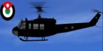

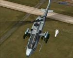
Nemeth UH-1H Huey RJAF Textures
(Category: FSX > Payware)
1.77Mb (326 downloads)
Royal Jordanian Air Force textures for the payware Nemeth design UH-1H Huey.
Posted Jun 28, 2013 15:37 by Mustafa Anssari
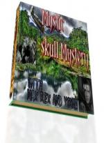
Max Rex in The Mystic Skull Mystery
(Category: FSX > Missions)
2.66Mb (1338 downloads)
Max landed in Cali, Colombia and was picked up by the lovely Illian Guster. Little did Max know the adventure he would share with this woman and her father, the well known Dr.Fullerton Guster who was sure he had the map for probably the largest treasure the Spanish Conquistadors had found in America!!...But, there were others who also knew the existance of the treasure and were determined to get it for themselves and no one else. Come to Colombia pilot, it's 1932 and the jungle of this country is open for adventurers and those with flying machines have a lead!!! Max needs YOU in this incredible adventure that will have you sitting at the edge of your cockpit to say the least..Vamos!!!!!
Posted Jun 28, 2013 11:08 by Gera Godoy Canova

TICOS L Aerolinea de Costa Rica. Boeing 757-200
(Category: FS2004 > Civil Jets)
0.87Mb (510 downloads)
TICOS, is a project to create a new airline based in Costa Rica.
FS2004 Boeing 757-200 model by Mike Stone included.
Posted Jun 28, 2013 07:44 by Mike Stone / Alberto Thomas

Bomb Ripple Switch for Helicopters
(Category: FSX > Helicopters)
3.47Mb (2482 downloads)
FSX PROGRAMMABLE RIPPLE BOMB RELEASE SWITCH - For Droppable Objects.
****" Enables multiple bombs to be dropped at a SINGLE click ".****
This version is for Helicopters only, DO NOT use on Fixed wing aircraft.
Assign TAILHOOK to a Controller button to maximise useage.
(1) Set Number of Missiles/Bombs required, Qty "No" 01 to 99. (2) Set Time Interval required between each bomb ,"TI" 0.00 to 9.99 seconds.
(3) then a SINGLE Click of release "Pickle" button sets off the Ripple drop that you have set .Eg; "No 12 - TI 0.01" = concentrated drop zone. While "No 24 - TI 0.50" = strung out drop pattern, it will take 12 seconds for all 24 bombs to drop from your Helicopter.All from a Single click.
MUST have the freeware "Weapons Package" by Chris Sykes installed.
Has Safe - Armed lights ,Ideal for any military Helicopter Gunship , the Weapons used is totally up to individual preferences , generally it would be missiles like the Maverick or Hellfire , if you chose to drop multiple bombs , then make sure that you have a good forward speed to create separation between the ground impacts.Works for both Bombs and Missiles.Distance interval chart included.Copy Allowed PDF with ID, image and dimensions for all weapons, provided to facilitate rapid copy/paste for weapon changes is included. Pave Tack all aspect/directions in cockpit viewer instrument that enables observation of bombs dropping and exploding from within the cockpit included. This package is "Public Domain" can be used or modified, or included in both free and payware projects without any limitations.
By Karol Chlebowski.
Posted Jun 28, 2013 04:54 by Karol Chlebowski