


All Files > Page 1578

FSX Bhutan Airfield Locator
(Category: FS Navigation > Flight Simulator Navigation)
2.67Mb (112 downloads)
Tested on Windows XP and Windows 7.
This download adds airfield markers and ICAO id's found in FSX, and overlays them on Google Earth.
This file is for Bhutan.
There is also a seperate file with a list of basic airfield location details.
i.e: EGBB Birmingham Airport. Birmingham. N52* 27.23' W1* 44.88' alt325.
Also the tidying "My places" in Google Earth, file.
Other locator files to follow.
by Carl Vokes
Posted Nov 13, 2012 15:01 by carl vokes
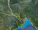
FSX Bangladesh Airfield Locator
(Category: FS Navigation > Flight Simulator Navigation)
2.60Mb (109 downloads)
Tested on Windows XP and Windows 7.
This download adds airfield markers and ICAO id's found in FSX, and overlays them on Google Earth.
This file is for Bangladesh.
There is also a seperate file with a list of basic airfield location details.
i.e: EGBB Birmingham Airport. Birmingham. N52* 27.23' W1* 44.88' alt325.
Also the tidying "My places" in Google Earth, file.
Other locator files to follow.
by Carl Vokes
Posted Nov 13, 2012 14:59 by carl vokes

Boeing 747-400 Corsairfly
(Category: FS2004 > Civil Jets)
12.12Mb (1677 downloads)
FS2004 Boeing 747-400 Corsairfly. Textures by Mathieu Vos (APSS). Model by Project Open Sky.
Posted Nov 13, 2012 12:28 by Chris E
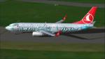
Boeing 737-800 Turkish Airlines
(Category: FS2004 > Civil Jets)
9.28Mb (2630 downloads)
FS2004 Boeing 737-800 Turkish Airlines registration TC-JHL. Skyspirit B737-800 of Turkish Airlines in the Globally Yours colors, registration TC-JHL. Repaint by Mathieu Vos (APSS), model by Project Open Sky/Skyspirit.
Posted Nov 13, 2012 12:24 by Chris E


Level D Boeing 767 Turkish Airlines FC Barcelona Textures
(Category: FSX > Payware)
2.16Mb (2171 downloads)
Turkish Airlines FC Barcelona textures for the payware Level D-767 Winglet model.
Textures by Peter Franeker.
Posted Nov 13, 2012 06:02 by Peter Franeker
Cali, Columbia mesh fix
(Category: FSX > Scenery)
0.01Mb (794 downloads)
For those of you who are using accurate terrain mesh this is a fix for Cali airport in Colombia. FSX has the airport about 800 feet lower than it should be. So if you use terrain mesh it looks like the airport is in a giant sinkhole. This fixes that plus I've added the terminal and the correct number of gates, so it looks better than the default.
Posted Nov 12, 2012 12:45 by archive
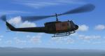
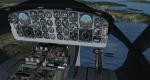
Bell UH 1D SAR 71 "Anneliese" Package
(Category: FSX > Helicopters)
6.78Mb (11138 downloads)
Bell UH 1D SAR 71 "Anneliese" package modified for FSX. Model by Jordan Moore. Sounds by Manuel Gonzalez.
Textures by Dirk Brandenburg. VC modified for FSX by Mike Litze.
Posted Nov 12, 2012 07:41 by Fritz Meier
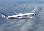
L1649 Starliner Lufthansa Textures
(Category: FSX > Vintage)
4.12Mb (848 downloads)
FSX/FS9 L-1649 Model by Manfred Jahn.
Lufthansa textures by Gary Harper.
Required files:
required file
Posted Nov 11, 2012 21:46 by Gary Harper
.jpg-thumb.jpg)
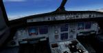
A320-200 Interjet Package with Improved VC V2
(Category: FSX > Civil Jets)
50.25Mb (5655 downloads)
Project Airbus A320-200 Interjet with modified A320 virtual 3d cockpit. ABC Aerolíneas, operating as Interjet, is a Mexican low-cost airline with its headquarters in Lomas de Chapultepec, Miguel Hidalgo, Mexico City. Interjet livery by Xudeva Irribarra. Improved virtual cockpit with PFD, ECAMS, improved ASI. Realistic A320-214 sound pack. Plus GPWS callouts. Also has views of motor extreme wing of wing and view of train. Full package.
Posted Nov 11, 2012 21:34 by javier guevara
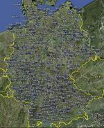
FSX Germany Airfield Locator
(Category: FS Navigation > Flight Simulator Navigation)
2.61Mb (508 downloads)
Tested on Windows XP and Windows 7.
This download adds airfield markers and ICAO id's found in FSX, and overlays them on Google Earth.
This file is for Germany.
There is also a seperate file with a list of basic airfield location details.
i.e: EGBB Birmingham Airport. Birmingham. N52* 27.23' W1* 44.88' alt325.
Also the tidying "My places" in Google Earth, file.
Other locator files to follow.
by Carl Vokes
Posted Nov 11, 2012 21:25 by carl vokes