


All Files > Page 1919
Dijon, Burgundy, France Area Upgrade
(Category: FS2002 > Scenery)
0.89Mb (271 downloads)
FS2002 Additional Small Terrains and Sceneries Around
These .bgl files for use with FS2002 will add some more details in the area of Dijon, Burgundy, France and useful for GA flights. Two additonal small terrains are to be found, Pouilly-Maconges (LFXI), West of Dijon and Nuits-St Georges-La Berchère (LFHU), South of that city which due to their rough surface or exiguity will be suited to soft-field or short-field pproach and landing training. Some additional scenery is available too to Darois (LFGI), home to the 'Aéro-Club de la Côte d'Or' and Tilchâtel (LFET), a smaller flying-club North of Dijon. The Nuits-St Georges antenna further, accurate ATC frequencies for LFXI and LFHU, or lake Kir, such sceneries will allow to improve the realism of any flight around Dijon. You will note that we did not figure taxiways in Darois as we estimate that the scenery aldready animate there. A treat consists, for Darois, to alternate files representing, for the summer period, a sailplane in the area where that activity occurs
Posted Aug 11, 2011 17:50 by G. Guichard
Fairchild PT-19 N1175N Textures
(Category: FSX > Vintage)
32.83Mb (658 downloads)
PT-19 N1174N textures for Tim Conrad's PT-19 package.
Required files:
required file
Posted Aug 11, 2011 10:38 by WODZU_EPGI
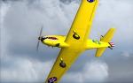
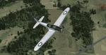
Aero L-39ZA
(Category: FSX > Military)
16.30Mb (29032 downloads)
FSX Aero L-39ZA
Attack variant of L39, significantly upgraded
L-39ZO with GSh-23L 23mm twin-barrelled
cannon attached under the pilot's compartment
by Harri Thaha & Hadi Tahir
Posted Aug 11, 2011 10:16 by archive
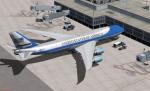
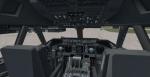
FSX Air Force One Boeing 747-8F Package
(Category: FSX > Civil Jets)
65.38Mb (14786 downloads)
FSX Air Force One Boeing 747-8F Package
Updated to work in FSX by Chris Evans using the FSX default B747-400 retouched VC and panel.
Custom Boeing sounds.
Air Force One Boeing 747-8F,the most acurate paintalong with realistic
shadow, shine and reflective effectsFeaturing 32bit Highly Detailed graphics
with night light effects,The model includes all the usual things as a steering
nosewheel, taxi and landing lights, dynamics shine and all moving parts,
including a fully animated landing gear animation. Some special things include
three opening doors, with visible interior. Flexing wings, wing views and
trim animation for the horizontal stabilisers.
Model, dynamics by: Project Opensky, great repaint by Aziz Palas.
Posted Aug 11, 2011 07:52 by Chris Evans
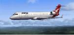
FSX Qantas Bombardier CRJ 700 Textures
(Category: FSX > Civil Jets)
6.32Mb (4135 downloads)
Qantas fictional textures for the default FSX Bombardier CRJ 700.
Posted Aug 11, 2011 06:26 by Ryan
Sloping Runway Scenery Tutorial
(Category: FS Design > Scenery Design)
11.37Mb (1672 downloads)
Design Tutorial for Sloping Runway Scenery
"The one aspect that has always bothered me
is all the ingredients for sloping runways
already exist in FSX."- Wally-Bob. So why are
there no sloping runways?" Can you apply
texture to a surface, make a sloping flatten
polygon and locate it accurately within the
FSX world? If you say yes, all you need is
how to turn that polygon into a hardened
surface. It's simple. By Walter Roberts
Posted Aug 10, 2011 18:21 by michael litze (uploader)
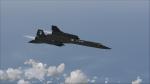
SR-71 Record Speed Run 2
(Category: FSX > Missions)
2.81Mb (3858 downloads)
SR-71 Record Speed Run 2
London to Los Angeles in 3:47:39, average speed 1249 knots, and distance 4745 NM. Generated with FSX Mission Editor.
Welcome to the second part of this interesting but very tricky mission. Be sure that you have the instructions printed out and next to you, otherwise you will be in lot of difficulties soon.
Remember although this mission seems long and is longer than the first mission, things happen very fast, seconds do play a major role in this mission.
Alphasim SR-71 available here
Posted Aug 10, 2011 17:27 by Robbie Albers
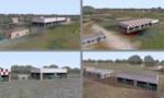
Gorlitz Airfield, Germany
(Category: FSX > Scenery)
(750 downloads)
This is an Addon for Gorlitz airfield in Germany.
The airport represents realistic layout of the runway and buildings.
Posted Aug 10, 2011 15:42 by Dennis Weiß
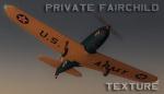
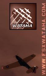
Fairchild PT-19 N641BP Textures
(Category: FSX > Vintage)
3.92Mb (958 downloads)
Private Fairchild PT-19 N641BP textures for Tim Conrad's PT-19 package.
Required files:
required file
Posted Aug 10, 2011 11:34 by WATAHA_ROAN
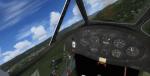
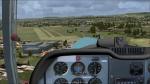
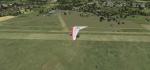
Fairchild PT-19B
(Category: FSX > Vintage)
18.91Mb (6831 downloads)
FSX SP-2 Acceleration
Fairchild PT-19B
WW2 USAAF Basic Training Aircraft. The Fairchild PT-19 (company designation Fairchild M62) was an American Fairchild Aircraft monoplane primary trainer aircraft that served with the United States Army Air Forces, RAF and RCAF during World War II. It was a contemporary of the Kaydet biplane trainer and was used by the USAAF during Primary Flying Training as the introductory pre-solo phase trainer for introducing new pilots to flying before passing them on to the more agile Kaydet. As with other USAAF trainers of the period, the PT-19 had multiple designations based on the power plant installed. By Tim Conrad
This release comes with multiple paint schemes, and fore and aft cockpit VC's.
Paint Kit included
Posted Aug 10, 2011 11:25 by michael litze (uploader)