


All Files > Page 1698
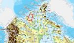
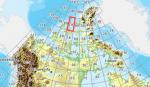
FSX Canadian CDED mesh above 60 degrees Lat 19 metre resolution Pt34, block 88.
(Category: FSX > Terrain Mesh)
95.80Mb (333 downloads)
As Raimondo Taburet hasn't processed the CDED files above 60 degrees latitude for Canada, well here are the ones I have processed.
There isn't any data available from geobase in some of the blocks above 60 degrees latitude, these are blocks: 15, 17, 18, 28, 108, 109, 118, 119.
See jpg for coverage.
Thanks go to Geobase (Copyright) Canada for the availability & public use of this data.
Posted May 19, 2012 05:01 by Wayne Evans
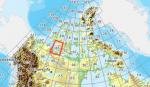
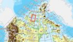
FSX Canadian CDED mesh above 60 degrees Lat 19 metre resolution Pt33, block 87.
(Category: FSX > Terrain Mesh)
91.67Mb (298 downloads)
As Raimondo Taburet hasn't processed the CDED files above 60 degrees latitude for Canada, well here are the ones I have processed.
There isn't any data available from geobase in some of the blocks above 60 degrees latitude, these are blocks: 15, 17, 18, 28, 108, 109, 118, 119.
See jpg for coverage.
Thanks go to Geobase (Copyright) Canada for the availability & public use of this data.
Posted May 19, 2012 04:36 by Wayne Evans
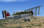

Westland Wapiti
(Category: FSX > Vintage)
4.76Mb (1448 downloads)
The Westland Wapiti
In 1926 the Air Ministry looked for a replacement for the long serving D.H 9A to fill the role of general-perpose aircraft for the RAF. Westland, who had been producing the D.H 9A on a sub-contract basis decided to offer a plane using parts of the D.H 9 . Although the fuselage was an entirely new design, the wings and interplane struts were from the old 9A. This design was named the Wapiti . At the outbreak of WWII several machine were still serving in the Middle East and saw limited active service .
GMAX model by A.F.Scrub
Posted May 19, 2012 04:19 by A.F.Scrub
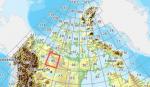
FSX Canadian CDED mesh above 60 degrees Lat 19 metre resolution Pt32, block 86.
(Category: FSX > Terrain Mesh)
159.04Mb (291 downloads)
As Raimondo Taburet hasn't processed the CDED files above 60 degrees latitude for Canada, well here are the ones I have processed.
There isn't any data available from geobase in some of the blocks above 60 degrees latitude, these are blocks: 15, 17, 18, 28, 108, 109, 118, 119.
See jpg for coverage.
Thanks go to Geobase (Copyright) Canada for the availability & public use of this data.
Posted May 19, 2012 04:19 by Wayne Evans

FSX Canadian CDED mesh above 60 degrees Lat 19 metre resolution Pt31, block 85.
(Category: FSX > Terrain Mesh)
110.24Mb (302 downloads)
As Raimondo Taburet hasn't processed the CDED files above 60 degrees latitude for Canada, well here are the ones I have processed.
There isn't any data available from geobase in some of the blocks above 60 degrees latitude, these are blocks: 15, 17, 18, 28, 108, 109, 118, 119.
See jpg for coverage.
Thanks go to Geobase (Copyright) Canada for the availability & public use of this data.
Posted May 19, 2012 03:50 by Wayne Evans
FSX Canadian CDED mesh above 60 degrees Lat 19 metre resolution Pt30, block 79.
(Category: FSX > Terrain Mesh)
22.48Mb (259 downloads)
As Raimondo Taburet hasn't processed the CDED files above 60 degrees latitude for Canada, well here are the ones I have processed.
There isn't any data available from geobase in some of the blocks above 60 degrees latitude, these are blocks: 15, 17, 18, 28, 108, 109, 118, 119.
See jpg for coverage.
Thanks go to Geobase (Copyright) Canada for the availability & public use of this data.
Posted May 19, 2012 03:30 by Wayne Evans
FSX Canadian CDED mesh above 60 degrees Lat 19 metre resolution Pt29, block 78.
(Category: FSX > Terrain Mesh)
62.34Mb (266 downloads)
As Raimondo Taburet hasn't processed the CDED files above 60 degrees latitude for Canada, well here are the ones I have processed.
There isn't any data available from geobase in some of the blocks above 60 degrees latitude, these are blocks: 15, 17, 18, 28, 108, 109, 118, 119.
See jpg for coverage.
Thanks go to Geobase (Copyright) Canada for the availability & public use of this data.
Posted May 19, 2012 03:23 by Wayne Evans
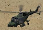
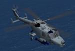
Views for the AlphaSim FSX Westland Lynx
(Category: FSX > Helicopters)
0.70Mb (1594 downloads)
Additional views ( defined by camera definitions in the aircraft.cfg file )
for the beautiful Westland Lynx by Alphasim now available for free and
adapted for FSX by Danny Garnier.
The update by Bob Chicilo is 100% compatible with my views but - in my
case anyway - there is a problem with the windows textures : can't see
through them.
8 cameras pointing at the aircraft and a total of 5 views in the 3D cockpit.
See Read me.txt file for very easy installation procedures.
One camera definitions.txt file for all models
And finally two more files - Available.pdf and Top 20.pdf for informations
about my "camera definitions" packages.
Required files:
required file
Posted May 19, 2012 00:46 by Marc Renaud

.jpg-thumb.jpg)
Default Boeing 737-800: N792XM Private Livery (Red, Orange, and Gold Stripes Textures
(Category: FSX > Civil Jets)
8.72Mb (533 downloads)
Textures for the default 737-800 in a private livery of N792XM. It has red, orange, and gold stripes. The livery and the tail number are fictional. By Tyler Lawrence.
Posted May 18, 2012 22:05 by Tyler Lawrence
.jpg-thumb.jpg)

Default Boeing 737-800: N405RG Private Livery Blue and Grey Belly Textures
(Category: FSX > Civil Jets)
8.62Mb (626 downloads)
Textures for the default 737-800 in a private livery of N405RG. It has a blue and grey belly. The livery and the tail number are fictional. By Tyler Lawrence.
Posted May 18, 2012 22:03 by Tyler Lawrence