


All Files > Page 1710
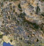
FSX Arizona Airfield Locator
(Category: FS Navigation > Flight Simulator Navigation)
1.10Mb (188 downloads)
Tested on Windows XP and Windows 7.
This download adds airfield markers and ICAO id's found in FSX, and overlays them on Google Earth.
This file is for Arizona.USA
There is also a seperate file with a list of basic airfield location details.
i.e: EGBB Birmingham Airport. Birmingham. N52* 27.23' W1* 44.88' alt325.
Also the tidying "My places" in Google Earth, file.
Other locator files to follow.
by Carl Vokes
Posted May 8, 2012 15:36 by carl vokes
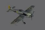
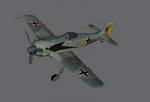
FSX Static FW 190 Scenery Object
(Category: FS Design > Scenery Design Objects)
0.78Mb (585 downloads)
This is the Focke Wulf FW 190 static plane for FSX. The plane comes in a library and can be placed in any scenery by any object placement tool. The plane comes in one model (Germany WWII). The plane was made in GMax by Guy Diotte and the texture also by Guy Diotte.
Posted May 8, 2012 14:46 by Guy Diotte

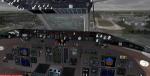
McDonnell-Douglas MD-83 FSX Package version 2
(Category: FSX > Civil Jets)
46.94Mb (90314 downloads)
McDonnell-Douglas MD-83 for FSX version 2. Features:
2D Cockpit.
Virtual Cockpit.
Working APU System. GPWS.
Working Flight Management Computer*."FMC" Bendix King/Honeywell General Aviation
FMC/GPS by Garrett Smith
Full animations including exit doors.
FSX terminal gate compatibility.
Working windshield wipers.
Wing flex.
...and many more realistic additions! Liveries:
Christian Michael Silvers (Alitalia, TWA, China Southern Airlines, Iberia, SAS)
Jordan Skok (Allegiant), Frequent Flyer (Finnair) Ricardo Torres (Lufthansa) Created and produced by:
Alejandro Rojas Lucena
Gauges by:
Alejandro Rojas Lucena (Some MD-80 specific gauges)
Microsoft (standard flight instruments)
Garrett Smith (FMC). Liveries by:
Christian Michael Silvers (Alitalia, TWA, China Southern Airlines, Iberia, SAS)
Jordan Skok (Allegiant), Frequent Flyer (Finnair) Ricardo Torres (Lufthansa)
Posted May 8, 2012 10:27 by alrot

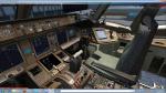
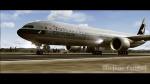
Cathay Pacific Boeing 777-300 ER Package
(Category: FSX > Civil Jets)
56.95Mb (11435 downloads)
Cathay Pacific Boeing 777-300 ER
With Bridgeston Tyres And photoreal windows!
Includes VC edited by Danny Garnier. Custom B777 sounds.
Wonderful Boeing 777-300ER GE VC model by Project Opensky.
Includes ground service (Views - Instrument Panel - Posky Utilities).
By Shrikar Galgali
Happy Flying!
Updated for FSX by Chris Evans
Posted May 8, 2012 09:33 by Chris Evans
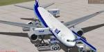
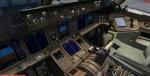
All Nippon Airways Boeing 777-281ER
(Category: FSX > Civil Jets)
39.36Mb (7693 downloads)
FSX All Nippon Airways Boeing 777-281ER
All Nippon Airways (ANA) founded in December 1952, as the growing company demanded more advanced
aircrafts with the company's success. All Nippon Airways added the first Boeing 777 to it's
fleet in late 1995 with the B777-281 registration JA8197. This repaint features the most
accurate and up to date ANA B777-281 in it's new livery; with full 32bit highly detailed
graphics. Includes ground service (Views - Instrument Panel - Posky Utilities) Giving the most realistic flight simulation experience.
ANA Repaint: Aziz Palas. Model by Project Opensky. Modified for FSX by Chris Evans.
Posted May 8, 2012 08:53 by Chris Evans
Cathay Pacific Boeing 777-300 ER
(Category: FS2004 > Civil Jets)
14.15Mb (2397 downloads)
Cathay Pacific Boeing 777-300 ER. Model by Project Opensky. Textures by Shrikar Galgali.
Posted May 8, 2012 08:49 by Chris Evans
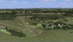
Progress Airfield, Sth Africa
(Category: FSX > Scenery)
8.73Mb (641 downloads)
Airfield located near Port Elizabeth, South Africa. Progress Airfield made from custom models and with a photo background that changes with the seasons .
Posted May 8, 2012 08:04 by Jacques Botha
.jpg-thumb.jpg)
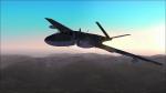
Heinkel P-1079A Jet Nightfighter
(Category: FSX > Vintage)
20.34Mb (3387 downloads)
Heinkel P-1079, a new twin-jet fighter project of the Heinkel Aircraft Construction Corp. was designed in five variations, all under the same designation.
The first of these advanced designs, the Heinkel P-1078A was basically developed as a two-seated nightfighter. The pilot and the gunner/navigator were sitting in tandem position. The wings were swept back 35 degrees, mounted to mid-fuselage. The tail had a V-shaped rudder. The armament were three Rheinmetall-Borsig MK 108 30mm cannons in the nose and 24 R4-M 'Orkan' high explosive rockets on two racks mounted under the wings. Another feature of armament was the so-called 'schraege musik' with four upward-firing 20 mm Mauser MG 151/20 autocannons, mounted in the back of the aircraft. Therefore, the nightfighter had to approach and attack bombers from below, guided into position by commands from the navigator.
The aircraft should be equipped with the new FUG 228 radar unit. This sophisticated radar would have empowered the aircraft with an almost all-weather ability.
The engines were located in the wing roots. This version should be fitted with two Junkers Jumo 004D turbojet engines with two-stage fuel injector, each with 8.8 kN of power.
The max. speed was about Mach 0.89 = 950kph
The Range 1079.22nm = 1241.9 sm = 2000 km
The max. Service Ceiling was up to 51,000 ft = 15,545m
Posted May 7, 2012 16:54 by Andreas Becker
.jpg-thumb.jpg)
.jpg-thumb.jpg)
Heinkel P-1079A Jet Nightfighter
(Category: FS2004 > Vintage)
20.34Mb (1989 downloads)
Heinkel P-1079, a new twin-jet fighter project of the Heinkel Aircraft Construction Corp. was designed in five variations, all under the same designation.
The first of these advanced designs, the Heinkel P-1078A was basically developed as a two-seated nightfighter. The pilot and the gunner/navigator were sitting in tandem position. The wings were swept back 35 degrees, mounted to mid-fuselage. The tail had a V-shaped rudder. The armament were three Rheinmetall-Borsig MK 108 30mm cannons in the nose and 24 R4-M 'Orkan' high explosive rockets on two racks mounted under the wings. Another feature of armament was the so-called 'schraege musik' with four upward-firing 20 mm Mauser MG 151/20 autocannons, mounted in the back of the aircraft. Therefore, the nightfighter had to approach and attack bombers from below, guided into position by commands from the navigator.
The aircraft should be equipped with the new FUG 228 radar unit. This sophisticated radar would have empowered the aircraft with an almost all-weather ability.
The engines were located in the wing roots. This version should be fitted with two Junkers Jumo 004D turbojet engines with two-stage fuel injector, each with 8.8 kN of power.
The max. speed was about Mach 0.89 = 950kph
The Range 1079.22nm = 1241.9 sm = 2000 km
The max. Service Ceiling was up to 51,000 ft = 15,545m
Posted May 7, 2012 16:24 by Andreas Becker
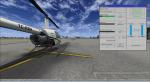
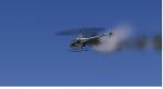
FSX Default Robinson R22 Beta II Damage Mod
(Category: FSX > Helicopters)
5.72Mb (1653 downloads)
This modification adds to your default FSX Robinson R22 wear/damage simulation and other nice effects.
Features:
-Engine wear and Damage Simulation
-Engine and Tailrotor Gearbox Oil use
-Engine Oil condition (Affects Engine Wear)
-Engine Oil Change (Every 25 Hours Like Real R22)
-Engine Vibration in Virtual Cockpit (If Engine or Tailrotor are damaged, or you fly greater than 100 knots vibration will be greater then normal and you hear cockpit rattles sound effect)
-Tailrotor Strikes if Tailrotor Gearbox Oil is low
-Cyclic Vibration (if Engine is running)
-Cockpit switches Sound Effects
-Cockpit Instruments takes Dirt
-Cockpit Instruments will Damage if you land the helicopter very hard!
Posted May 7, 2012 14:41 by Ismail Hakki Guezel