


All Files > Page 1616

587 Painters Fonts
(Category: FS Design > Aircraft Paintkits)
12.68Mb (935 downloads)
For those repaint guys and gals out there, here are 587 fonts. This way you can get close to exact airline fonts if not match it 100%. Enjoy
Posted Sep 22, 2012 11:53 by John Lear
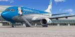
Boeing 737-700 Aerolineas Argentinas with advanced VC
(Category: FSX > Civil Jets)
19.64Mb (7352 downloads)
Boeing 737-700 Aerolineas Argentinas winglets with advanced VC
for Microsoft Flight Simulator X
Skyspirit/Project Opensky native FSX Boeing 737-700 winglet model.
Upgraded to FSX using Alrot's revised Boeing 737-800 VC. This model includes Working
wipers (right mouse click on switch) with rain effect. Switches for LCD Screens,
EICAS, PFD, MFT. Autobrake switch. Opening pilots window. Cabin Lights switch.
Realistic FMC. Ground Proximity Warning System (GPWS), More Realistic night textures.
FSX native model winglet by Skyspirit/Project Opensky.
High quality textures by Xudeva Irribarra.
Modified and assembled for FSX by Chris Evans.
Posted Sep 22, 2012 07:38 by chris evans
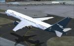
Boeing 757-200 Ryan International Package
(Category: FS2004 > Civil Jets)
32.45Mb (6332 downloads)
This package depicts a 757-200 of Ryan International Airlines around 2006. The airline, once known for airfreight services and passenger charters to holiday destinations like Mexico, the Hawaiian Islands and the Caribbean, switched to a business model built around providing transportation services to the U.S. Department of Defense. As of 2012, the airline was in bankruptcy.
This is a complete package. Model by Project Opensky, panel by Ken Mitchell, VC by Wilhelm Hudetz, sound by Emil Serafino, textures by Eugene Douglas.
Posted Sep 21, 2012 20:04 by Eugene Douglas
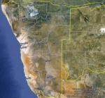
FSX Namibia Airfield Locator
(Category: FS Navigation > Flight Simulator Navigation)
2.52Mb (122 downloads)
Tested on Windows XP and Windows 7.
This download adds airfield markers and ICAO id's found in FSX, and overlays them on Google Earth.
This file is for Namibia.
There is also a seperate file with a list of basic airfield location details.
i.e: EGBB Birmingham Airport. Birmingham. N52* 27.23' W1* 44.88' alt325.
Also the tidying "My places" in Google Earth, file.
Other locator files to follow.
by Carl Vokes
Posted Sep 21, 2012 13:54 by carl vokes
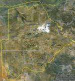
FSX Botswana Airfield Locator
(Category: FS Navigation > Flight Simulator Navigation)
2.51Mb (110 downloads)
Tested on Windows XP and Windows 7.
This download adds airfield markers and ICAO id's found in FSX, and overlays them on Google Earth.
This file is for Botswana.
There is also a seperate file with a list of basic airfield location details.
i.e: EGBB Birmingham Airport. Birmingham. N52* 27.23' W1* 44.88' alt325.
Also the tidying "My places" in Google Earth, file.
Other locator files to follow.
by Carl Vokes
Posted Sep 21, 2012 13:51 by carl vokes
FS2004 Cessna Skymaster Textures (N574VS)
(Category: FS2004 > Props)
0.19Mb (606 downloads)
A repaint of Mike Stone's Cessna 337 in a white over dark violet scheme. These are the textures only, you will need sc337.zip to use. Repaint by Don Brynelsen using Mike's paintkit.
Required files:
required file
Posted Sep 21, 2012 13:00 by Don Brynelsen
FSX SAA Boeing 747 Splashscreen
(Category: Videos/Splashscreens > Splashscreens)
0.29Mb (1347 downloads)
FSX Splashscreen: South African Airways Boeing 747 landing at Rand airport narrow runway.
NARROW RUNWAY
Posted Sep 21, 2012 11:46 by ALI GAFFOOR
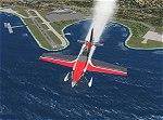
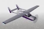
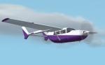
Aeroworks ARX-5 Coyote v2.1 Package
(Category: FSX > Props)
41.05Mb (5180 downloads)
The ARX-5X (Concept 5) is a single-seat unlimited category aerobatic aircraft built around the 495c.i. 600hp Trace-Orenda OE600 V-8 aircraft engine and designed specifically for freestyle airshow type aerobatics. Version 2 has a totally new airfile and flight dynamics and the plane can easily handle compulsory competition maneuvers as well as more advanced gyroscopic maneuvers such as lomcovaks and tumbles. The ARX-5X cruises around 200kts, with a never-exceed speed of 240kts. This FSX native model contains animations, reflections, environment mapping, spec mapping and a full dynamic virutal cockpit. Although it is not a real aircraft it does have several real-world components such as the Chelton Fligh Systems EAU (engine airdata unit) display, and a Hartzell "scimitar" swept blade propeller. This release is not a quick & dirty update simply "ported" into FSX, it is a full FSX rebuild by the original authors, compiled with XtoMDL and conforming the FSX SDK using dds textures and new modeling techniques for the best overall end-user performance. Includes 2 configs, 7 models, and 20 schemes with a custom smoke system and night time pyrotechnic effects. Aircraft, effects, and panel by Jason L. Terry and Mike VIvaldi. Aditional Skins by Brady Duros and Joshua B. Nyhus.
This is a Version 2.1 update from the original authors, it includes cripser DDS-888 textures and a Windows 64-bit friendly envmap.
Posted Sep 21, 2012 07:53 by Jason L. Terry
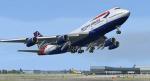
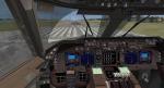
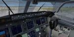
Boeing 747-436 British Airways 'Benyhone Tartan' package with Advanced VC
(Category: FSX > Civil Jets)
36.93Mb (10076 downloads)
Boeing 747-436 British Airways 'Benyhone Tartan' package with advanced VC
Assembled and edited for FSX with Enhanced VC from Alejandro Rojas Lucenda. Package
assembled and edits by Chris Evans. Thank you to Skyspirit for their wonderful
models. Professional BA repaint by Xudeva Irribarra.
Skyspirit FSX native Boeing 747-400 model upgraded using the vastly improved Boeing
747 VC from Alejandro Rojas Lucena/FSND (See panel docs for details). VC includes
FMC, EICAS, MFD with control panel, GPWS, working wipers, cabin lights, fire
suppression, avionics switch, fuel crossfeed, landing lights switches, taxi light
switch, engine generators, APU generator, battery switch, starter switches, de-ice
switch, general lights switches. Beautiful Skyspirit 747-800 cargo model with complex
features and ground service vehicles (press shift e 2, shift e 3, etc. ). To use
jetway press Ctrl J.
Also includes the Boeing 747 VC textures upgrade by Jason A. Lee. This give a much
clearer 747 interior virtual cockpit look.
Assembled and edited for FSX by Chris Evans.
Zip preview for larger pictures.
See panel docs and images for VC details and controls!
Posted Sep 21, 2012 07:48 by chris evans
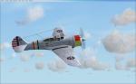
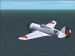
Curtiss P-36/H-75 Hawk Package
(Category: FSX > Vintage)
54.27Mb (2598 downloads)
Curtiss P-36A&C/H-75A Hawk-pack for FSX-Acceleration. The models are from 2 different authors, so ALL credits are for them! Both have working VC's and a vintage minipanel. All necessary gauges included.
12 Different liveries, also from different artists. Gun-effects for fun. Hope you enjoy flying them as much as I enjoyed reworking them.
Posted Sep 21, 2012 06:32 by erik hertzberger