


All Files > Page 1712
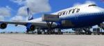
United Airlines Boeing 747-400 Package
(Category: FSX > Civil Jets)
22.00Mb (5449 downloads)
Project Opensky B747-400 v4 FSX model in the United Airlines N178UA. Features recolored default 747 VC, Ground services. Posky utilities to enable ground service traffic and stairs. (Find it under Views-Instrument panel - Posky Utilities). Textures by Xudeva Irribarra.
Upgraded to FSX model by Chris Evans.
Posted May 6, 2012 15:16 by Chris Evans
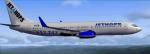

FSX Boeing 737-800 Jet Hops Group Textures
(Category: FSX > Civil Jets)
8.08Mb (544 downloads)
This package includes the default Boeing 737-800 textures of the JETHOPS group. Find their session in the FSX GameSpy lobby! Textures hand-made by kilocharlie1.
Posted May 6, 2012 15:14 by kilocharlie1

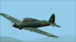
Savoia-Marchetti SM 93
(Category: CFS2 > Aircraft)
8.11Mb (467 downloads)
The SM-93 was an all-wood single-engined low-wing dive bomber with retractable undercarriage. The fuselage had a monocoque structure, with a single fin and low-set tailplane. The crew of two were accommodated under a long greenhouse-style canopy, with the pilot lying in a prone position above the rear of the engine, a Daimler-Benz DB 605A liquid-cooled V12 engine, while the and the gunner/radio-operator sat facing rearwards on a conventional seat. One German and two Italian what if finishings. Model by F Guili.
Posted May 6, 2012 10:41 by Pepe Rezende
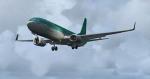
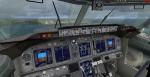
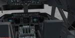
Boeing 737-800WL Aer Lingus with Enhanced VC
(Category: FSX > Civil Jets)
17.29Mb (5149 downloads)
Boeing 737-800WL Aer Lingus.
Skyspirit/Project Opensky native FSX Boeing 737-800 winglet model.
Upgraded to FSX using Alrot's revised Boeing 737-800 VC. This model includes Working wipers (right mouse click on switch) with rain effect. Switches for LCD Screens, EICAS, PFD, MFT. Autobrake switch. Opening pilots window. Cabin Lights switch. Realistic FMC. Ground Proximity Warning System (GPWS), More Realistic night textures.
FSX native model winglet by Skyspirit/Project Opensky. VC by Alejandro Rojas Lucena (Alrot).
Textures by Thomas Irlam.
Modified for FSX by Chris Evans.
Posted May 6, 2012 07:33 by Chris Evans
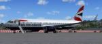
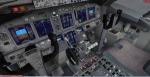
British Airways Boeing 737-800 with Enhanced VC
(Category: FSX > Civil Jets)
19.38Mb (8634 downloads)
FSX: British Airways B737-800
Skyspirit/Project Opensky native FSX Boeing 737-800 winglet model.
Upgraded to FSX using Alrot's revised Boeing 737-800 VC. This model includes Working wipers (right mouse click on switch) with rain effect. Switches for LCD Screens, EICAS, PFD, MFT. Autobrake switch. Opening pilots window. Cabin Lights switch. Realistic FMC. Ground Proximity Warning System (GPWS), More Realistic night textures. Model Featuring 32bit Highly Detailed graphics with night light effects,
the model includes all the usual things as a steering nose wheel, taxi and landing
lights, dynamics shine and all moving parts, including a fully animated landing gear
animation. Some special things include three opening doors, with visible interior.
Flexing wings, wing views and trim animation for the horizontal stabilizers.
Model, dynamics by: Project Opensky, Repaint By: Aziz Palas.
FSX native model winglet by Skyspirit/Project Opensky. VC by Alejandro Rojas Lucena (Alrot).
Textures by Aziz Palas.
Modified for FSX by Chris Evans.
Posted May 6, 2012 04:46 by Chris Evans
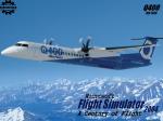
FS2004 Bombardier Dash-8 Q400 Splash Screen
(Category: Videos/Splashscreens > Splashscreens)
0.70Mb (364 downloads)
FS2004 Bombardier Dash-8 Q400 Splash Screen made using a photo from Bombardier.
Posted May 5, 2012 22:01 by Ryan Klatt
FS2004 to FSX Prop Textures 3-pack
(Category: FSX > Props)
0.11Mb (1115 downloads)
Propeller texture 3-pack for FS2004 aircraft when used in FSX.
Your choice of 2-blade, 3-blade, or 4-blade propeller textures.
Subtle and as transparent as I could make them, these props will
make many FS2004 airplanes more FSX friendly.
Saved as 32 bit bitmaps, but easily converted via your DXTBMP program
to DXT3 or even DDS textures. I've tested all these prop textures as
32 bit bitmaps, DXT3 bitmaps, and DDS (32 bit) textures in FSX SP2 and all
work fine. Easy installation instructions. I offer these to the
flight sim community as PUBLIC DOMAIN. Use them in any way that you
please! No restrictions. An up-close screenshot is enclosed. By Tom Tiedman.
Posted May 5, 2012 20:27 by Tom Tiedman
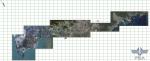

The City of Shenzhen, China, Photo Scenery
(Category: FSX > Scenery)
11.73Mb (4267 downloads)
Photoreal scenery covering Nanshan, Futian, Luohu and Yantian districts (Dameisha and Xiaomeisha) Guangdong, CHINA.
Blend mask and water mask clever placed to blend the photoreal scenery seamlessly into the default FSX scenery
Hand placed thousands of objects, to represent this megacity in its full glory
Hand placed super tankers and yachts traffic, to represent the real harbour environment
Animals and birds realistically placed around mountains to give our helicopter pilots more challenge
Framerate friendly design, using most of FSX's default building and object library
Posted May 5, 2012 13:55 by Jacques Lees
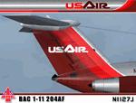
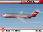
US Air Metal Fuse BAC 1-11 204AF (N1127J)
(Category: FS2004 > Civil Jets)
21.52Mb (4259 downloads)
I am very proud to present this very detailed and realistic repaint of the BAC 1-11 204AF model by David Maltby in the classic US Air livery from the early 80's. This was one of the original jets flown by US Air. It flew side by side in their fleet with the B727, DC9 and 737-200. This repaint is the result of a major overhaul of the paintkit for this aircraft, and is very detailed and realistic. The many new details and hand repainted items include; custom metal fuselage, custom windows, custom tail textures, hand painted wheels, and also much needed night lighting and night textures. The US Air logo is also hand painted. All repainted textures in this package are 32-bit with no mipmaps. This repaint is dedicated to Lorne Jordan, a Canadian simmer who inspired this project and who helped Q/A this repaint so we didn't miss a detail. Thanks to the permission granted by the gracious and talented David Maltby (creator of this aircraft model), this is a full installation package, complete with 2D panel, virtual cockpit and BAC 1-11 sounds. Please select Zip file preview to view detailed screenshots included with this package. Also see README.TXT for installation instructions. Repaint by Jeffrey S. Bryner and Lorne Jordan. Model, panel and sounds by David Maltby.
Posted May 5, 2012 10:16 by Jeffrey S. Bryner
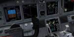
Boeing 737-800 Gauge - Black Background
(Category: FSX > Panels)
2.69Mb (2725 downloads)
This is the default FSX Boeing 737-800 gauge recolored to give a black background instead of blue on the instrument screens. Backup your original gauge and simply place this gauge inside the panel folder of your 737 using the default B737_800.CAB.
Posted May 5, 2012 09:37 by kraleks