


All Files > Page 2840
0.06Mb (1859 downloads)
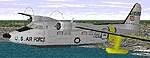
FS98 DH
114 Heron -USAir Series2A Reg. N14FB of US AIR - Allegheny
Commuter by Les Penridge. revised flight model by Brian Horsey.
File size 113970
Posted Aug 24, 2009 06:42 by archive
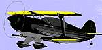
0.06Mb (1859 downloads)
FS98 Black
Eagle 540 (highly modified Pitts)The Official BlackEagle540.
With Certified ADC Flight Dynamics. This Highly modified Pitts
is completely different from any other. Flight Module by Renato
D. Pullin. New Paint, Modified body and Flight Dynamics by Jim
Coarse. File size 51811
Posted Aug 24, 2009 06:42 by archive
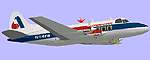
0.06Mb (1859 downloads)
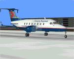
FS98 American
Eagle Saab S340B For Flight Simulator FS98 Model by : M.D.Baclawski
Artwork by : Tony Bolton Flight parameters for FS98 and creating
of landing lights : Jens Borgstroem. File size 533513
Posted Aug 24, 2009 06:42 by archive
FS98/2000
Raytheon/Beechcraft 1900D
(Category: FS98 > Props)
0.07Mb (534 downloads)
FS98/2000
Raytheon/Beechcraft 1900D Twin Turboprop Regional Commuter
Ontario Regional Reg# G-GWGA Ver3 with Steerable Nose Gear Design,Artwork,FD
by Barry Blaisdell. 60K
Posted Aug 24, 2009 06:42 by archive
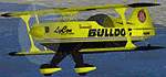
FS98/FS2000
Jim LeRoy's Pitts S-2S Bulldog V.2
(Category: FS98 > Props)
0.10Mb (776 downloads)
FS98/FS2000
Jim LeRoy's Pitts S-2S Bulldog V.2 Start with a factory
built Pitts S2S, add stronger wings, build a larger, more powerful
motor, add an oversized, custom propeller, increase the sizes
of all the control surfaces, reshape the tail, strengthen the
fuselage, and re-design the fuel and oil systems and you have
what Jim calls the "Bulldog" Pitts S2S. Includes FULL MOVING
PARTS and transparent canopy. This version fixes a couple of
bugs and adds new, realistic flight dynamics. Designed by Mikko
Maliniemi. Flight testing by Jim LeRoy himself. 105K
Posted Aug 24, 2009 06:42 by archive
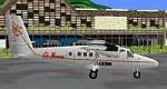
AIR
MOOREA DHC6-300S Twin Otter For FS98/2000
(Category: FS98 > Props)
0.06Mb (393 downloads)
AIR
MOOREA DHC6-300S Twin Otter For FS98/2000 with Full Moving
Parts AF99/AA Design & Artwork: Barry Blaisdell Flight Dynamics:
Jens Borgstroem. Repaint in Air MOOREA by Poukiki. 60K
Posted Aug 24, 2009 06:42 by archive
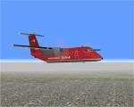
FS98/2000
Dehavilland DASH8-100 Nortwest AirLink (Mesaba)
(Category: FS98 > Props)
0.06Mb (409 downloads)
FS98/2000
Dehavilland DASH8-100 Nortwest AirLink (Mesaba) N861MA With
Maximum Moving Parts Rev3 with steerable nose wheel. AF99 Design
& Artwork: Barry Blaisdell Flight Dynamics: Jens Borgstroem.
62K
Posted Aug 24, 2009 06:42 by archive
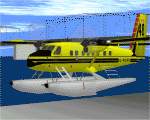
Dehavilland
DHC6-100 Twin Sea Otter
(Category: FS98 > Props)
0.05Mb (465 downloads)
FS98
Dehavilland
DHC6-100 Twin Sea Otter All New & Updated Rev 3 Aircraft
Canadian Ministry Reg # C-FOPI For FS98/2000 with Full Moving
Parts Design & Artwork: Barry Blaisdell Flight Dynamics: Jens
Borgstroem. 57K
Posted Aug 24, 2009 06:42 by archive
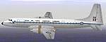
RAF
Bristol Britannia C Mk 1
(Category: FS98 > Props)
0.65Mb (536 downloads)
FS98
RAF
Bristol Britannia C Mk 1 DESIGNER : Richard Osborne REPAINTED
BY : Stephen J Muscat, includes sounds files. 680K
Posted Aug 24, 2009 06:42 by archive
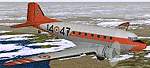
FS98
Replacement Sounds--Douglas DC-3 Dakota (or military C-47).
(Category: FS98 > Props)
0.69Mb (623 downloads)
FS98
Replacement Sounds--Douglas DC-3 Dakota (or military C-47).
Recording from the actual plane, these FS98 replacements
sounds are in stereo with CD sound quality. FS98 uses a range
of sounds, for inside and outside the cockpit, for different
engine speeds, as well as landing gear, flaps, screetch...this
file contains replacements for the full set of sounds. Created
by Trev (DC-3) Morson. 726K
Posted Aug 24, 2009 06:42 by archive