


All Files > Page 3764
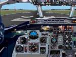
Boeing
737-200 panel for FS2002
(Category: FS2002 > Panels)
6.30Mb (1967 downloads)
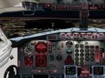
Boeing
737-200 panel for FS2002 1024x768 Based on real photos from
airliners.net, panel highly realistic, gauges by varios freeware
designers. This panel is designed for FS2002 1024x768 resolution,
includes fotoreal interior wiews, special nighlighted (frame
rate friendly!) some custom gauges, requires FS2000 concorde
gauge. Panel by Helio Estrela. 6.4MB
Posted Jun 23, 2008 14:32 by archive
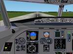
Fokker
70 -100 Panel for FS2002/FS2000
(Category: FS2002 > Panels)
1.11Mb (946 downloads)
Fokker
70 -100 Panel for FS2002/FS2000 Here you can see my first
EASY PANEL! This means FRAME RATE friendly! This panel is designed
for FS2000 and FS2002, and is also compatible with: VCP2000,
GPWS, Airbus Warning sounds, and the Airport 2000 series. This
panel has also cabin signs, and the usual things! I have also
included my first version of my INFO CENTER (designed in Visual
Basic). This is a stand alone program. There is also 1 winampskin
included! By Frank Elfert. 1.1MB
Posted Jun 23, 2008 14:32 by archive
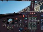
FS2002
Casa C212
(Category: FS2002 > Panels)
1.87Mb (785 downloads)
FS2002
Casa C212. This is my first version the bitmap isn´t it
of a lot of resolution but is the same that in the life and
all of the gauges(or a few isn´t it). I realize this panel because
I didn´t know how was the panel in the real life and y was lookin
for information and pictures and this is the result. By Ignacio
Alemany Hernández "Maver" 1.9MB
Posted Jun 23, 2008 14:32 by archive
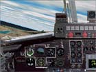
Boeing
727 panel (fs200x standard/PRO)
(Category: FS2002 > Panels)
4.89Mb (1477 downloads)
Boeing
727 panel (fs200x standard/PRO) Here you can see my first
version of my Boeing 727! This panel is designed for FS2000
and FS2002, and is also compatible with: VCP2000, GPWS, Airbus
Warning sounds, and the Airport 2000 series. This panel has
also cabin signs, interal views, AP pop-up support and GPS!
I have also included my first version of my INFO CENTER (designed
in Visual Basic). This is a stand alone program. By Frank Elfert.
5MB
Posted Jun 23, 2008 14:32 by archive
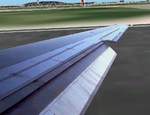
FS2000-2002
DC9 wing-views.
(Category: FS2002 > Panels)
0.70Mb (884 downloads)
FS2000-2002
DC9 wing-views. Read README file to adjust panel.cfg file
for correct perspective. Jim Waters. 716K
Posted Jun 23, 2008 14:32 by archive
FS2002
Pro 727 panel,1024x768 res with external views
(Category: FS2002 > Panels)
(1849 downloads)
FS2002
Pro 727 panel,1024x768 res with external views. Buckz. 3.9MB
Posted Jun 23, 2008 14:32 by archive
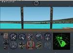
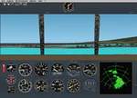
FS2002
WWII British ships panel
(Category: FS2002 > Panels)
0.20Mb (276 downloads)
FS2002
WWII British ships panel With radar. By Jean-Jacques Parel
Unknown author of the radar. 200K
Posted Jun 23, 2008 14:32 by archive
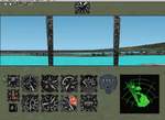
FS2002
WWII Japanese ships panel With radar.
(Category: FS2002 > Panels)
0.16Mb (264 downloads)
FS2002
WWII Japanese ships panel With radar. By Jean-Jacques Parel.
164K
Posted Jun 23, 2008 14:32 by archive
FS2002
WWII US ships panel With radar.
(Category: FS2002 > Panels)
0.20Mb (409 downloads)
FS2002
WWII US ships panel With radar. By Jean-Jacques Parel. 207K
Posted Jun 23, 2008 14:32 by archive
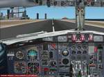
FS2002
- Panel DC-9.
(Category: FS2002 > Panels)
2.13Mb (1182 downloads)
FS2002
- Panel DC-9. REPLACES DC-9 panel packaged together with
Continental DC-9 old livery of 12April, 2002. Fixes all of
the numerous bugs and nubs on bitmap. Delete old file. Jim
Waters. 2.2MB
FS2002
- DC9 FIX 1!!! Sound file not found erro - fixed. Starts
right up. Some gauges removed with no corresponding sound
file. 481K
Gauges.
621K
Posted Jun 23, 2008 14:32 by archive