


All Files > Page 4848

FS2004 "FlighTease... a Tease Flight"
(Category: FS2004 > Adventures)
3.33Mb (2398 downloads)
FS2004
"FlighTease... a Tease Flight"
(no offensive images inside) Fly in the Hong Kong's sky, disused
Hong Kong Intl (VHHX) is available to give us hospitality, through
8 'very special' gates at assigned speed and altitude, make
a precision landing and the girl will show her best side!!!
6 gates gives you 10 points and 2 gives 20 points (they are
just a little more difficult), the precision landing gives 50
points. From the combination of this points your final score
could will be: 60, 70, 80, 90, 100, 110, 120, 130, 140 or 150.
The girl's generosity will be proportional at your piloting
ability! Two mistakes are allowed. Text and vocal messages will
help you during the flight. After takeoff heading indicator
will be automatically setted driving you gate by gate and until
to the base where you'll have what you merit;-). You'll have
speed and altitude information when near the gates, vocal and
text messages help you during the flight. Software accept a
range of +- 20 feet and +- 5 knots… enjoy this flight!!! English
and Italian version available. By SEA of Michele Giandomenico.
3.4MB
Posted Jun 23, 2008 14:19 by archive
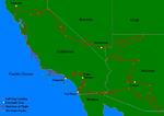
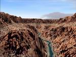
FS2004 The American Southwest Tour
(Category: FS2004 > Adventures)
0.18Mb (2319 downloads)
FS2004
The American Southwest Tour.
(version 2 for FS2004) Finally, after 4 years, here is the updated
FS2004-version of usatour.zip, the documentation of my personal
VFR (FS2000) flightsim tour of the US-American Southwest with
the C182RG. The tour has been modified for FS2004, completely
debugged and even extended to include more great destinations
in southern California. Includes detailed flight descriptions
of 32 VFR legs covering California, Nevada and Arizona. Features
scenic flights and realistic weather. Basic flightsim and real
aviation skills required to fly the tour. Only for FS2004. No
charts required. The Carenado C182RG is recommended but not
required. By Philipp Tiemann. 180K
Posted Jun 23, 2008 14:19 by archive
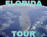
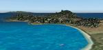
FS2004 Florida Tour.
(Category: FS2004 > Adventures)
4.66Mb (4142 downloads)
FS2004
Florida Tour.
Here are a set of 11 VFR flight plans to explore the state of
Florida. The flight plans are designed to fly over some of the
very interesting points in the State: Lakeland, Tampa, Clearwater,
St. Petersburg, The Keys, Miami, Disney World, Cape Canaveral,
Jacksonville, the Panhandle, Pensacola, and Tallahassee. Each
flight ranges from about 30 to 60 minutes in duration. This
package contains the flight plans, and documentation. By Paul
Schwerdtfeger. 4.8MB
Posted Jun 23, 2008 14:19 by archive
Concorde Bahrain tro London Flight.
(Category: FS2004 > Adventures)
0.00Mb (1176 downloads)
Concorde
Bahrain tro London Flight.
This is an attempt to replicate the Bahrain to London flight
Concorde flew as part of its world tour. The section of the
flight over Europe should be flown at mach 0.95 as cross land
supersonic flight was not allowed. The decelleration piont is
as you come up along Italy. Mark Richards. 2K
Posted Jun 23, 2008 14:19 by archive
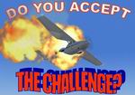
FS2004 The Challenge (2nd Update).
(Category: FS2004 > Adventures)
3.80Mb (3130 downloads)
FS2004
The Challenge (2nd Update). Do
you want to test your pilot’s skill? Are you ready to accept
the challenge? Fly in the Sydney’s sky through 8 'very special'
gates at assigned speed and altitude, make a precision landing
following the glide slope and you’ll win the challenge! Do you
think it is simple? There is a little problem… the jury isn’t
very friendly and accepts just two mistakes, in fact, at the
third mistake they launch a ground-to-air missile to shoot you
down!! Several special effects are waiting you along the route…
discover them by yourself! English and Italian language supported.
By SEA (Sceneries-Effects-Adventures) of Michele I-MIKY Giandomenico
3.9MB
Posted Jun 23, 2008 14:19 by archive
FS2002 Simon's Adventure Flights:
(Category: FS2002 > Adventures)
0.06Mb (3472 downloads)
FS2002
Simon's Adventure Flights: --
A series of adventures flights which will put to a hard test
your pilot abilities. Don't try any flight at full stomach,
it can have nasty consequences... However, these are very challenging
flights with not much fuel, carriers and much other! By Simone
Carnevale. 62K
Posted Jun 23, 2008 14:19 by archive
FS2004 10 Adventures in the World.
(Category: FS2004 > Adventures)
0.24Mb (3845 downloads)
FS2004
10 Adventures in the World.
These are 10 flights which will put to the test your abilities
of virtual pilots. You must adapt at several meteo situations
with several aircraft. If you want, after finishing a flight,
you can modify flight conditions to make it more difficult and
re-try to complete it again. 244K
Posted Jun 23, 2008 14:19 by archive
FS2004 Return from Holiday Adventure.
(Category: FS2004 > Adventures)
0.10Mb (2673 downloads)
FS2004
Return from Holiday Adventure.
This is an adventure in the Caribbean (4 flights). During the
flight you can see wonderful views and you can also fly in formation
with another Cessna! You will fly across the Caribbean from
Trinidad and Tobago to New Orleans. 108K
Posted Jun 23, 2008 14:19 by archive
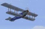
FS2004 Contintental Crossings
(Category: FS2004 > Adventures)
0.08Mb (1214 downloads)
FS2004
Contintental Crossings.
You are a rash sky-conqueror piloting a Curtiss Jenny. You want
to assert three new records: three dangerous crossings with
a light and fragile plane like a Curtiss Jenny! The territories
you must cross are hostile and without life: Canada, Sahara
and the australian desert are some of the more uninhabited lands
in the world. 81K
Posted Jun 23, 2008 14:19 by archive
FS2004 Photos from the World Helitour.
(Category: FS2004 > Adventures)
0.15Mb (1485 downloads)
FS2004
Photos from the World Helitour.
A photographer has asked to you if you can take him across the
world by helicopter, by a Bell 206B JetRanger: he wants to fill
some albums with photos taken from the sky. You have accepted
and you're going to leave. 152K
Posted Jun 23, 2008 14:19 by archive