


All Files > Page 4966
FSX
Boeing 737-800 Continental Textures
(Category: FSX > Civil Jets)
3.17Mb (5718 downloads)
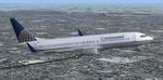
FSX
Boeing 737-800 Continental Textures.
Default Boeing 737-800 in Continental Airlines livery. Patrick
Finch. 3.2MB
Posted Jun 23, 2008 14:17 by archive
FSX
Ryanair Boeing 737-800 default Textures
(Category: FSX > Civil Jets)
3.70Mb (12138 downloads)
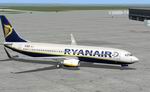
FSX
Ryanair Boeing 737-800 default Textures,
registration EI-DCK. Revised textures for the default B737-800
with better blending of colours. Includes flight from Prestwick
to Dublin. By George Hutton. 3.8MB
Posted Jun 23, 2008 14:17 by archive
FSX
Boeing 737-800 US Airways Textures
(Category: FSX > Civil Jets)
3.01Mb (5010 downloads)
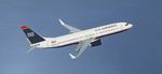
FSX
Boeing 737-800 US Airways Textures This
is a repaint for the FSX default Boeing 737-800. It includes
1 paint scheme for US Airways. Repainted by Mitchell Matthews.
3.1MB
Posted Jun 23, 2008 14:17 by archive
FSX
Boeing 737-700 Southwest Airlines Liveries Package v2.2 Final
Package
(Category: FSX > Civil Jets)
13.52Mb (7518 downloads)
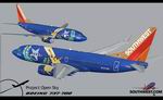
FSX
Boeing 737-700 Southwest Airlines Liveries Package v2.2 Final
Package Additional changes since its introduction include
a new interior and performance enhancing winglets which reduce
fuel consumption and improve take-off and climb performance.
All textures have been modified in DXT-3 format for crisp visuals
without comprimising frame rates. Includes the default FS-X
Boeing 737 panel. Sounds have been defaulted to the FS-X 737-800.
Additionally, this aircraft series has no Virtual Cockpit (VC),
therefore you must fly them using the 2-D default panel
view only! This package includes Southwest Airlines
liveries (Canyon Blue, Maryland One, Nevada One, Old Color &
Shamu). Aircraft by Project Opensky. Brian C. Selb. 13.8MB
Posted Jun 23, 2008 14:17 by archive
FSX
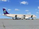
Airbus A321 Saudi Arabian Airlines Textures
(Category: FSX > Civil Jets)
7.80Mb (5469 downloads)
FSX
Airbus A321 Saudi Arabian Airlines Textures.
This is a repaint of the default FSX Airbus A321 in Saudi Arabian
Airlines. Saudi Arabian Airlines started out in 1945 with a
single twin-engined DC-3(Dakota) HZ-AAX. Today, Saudi Arabian
Airlines fleet is among the youngest in the world. Repaint by
Azrin Jumat. 8MB
Posted Jun 23, 2008 14:17 by archive
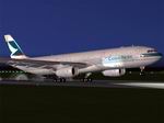
FSX Project Opensky A330-300 Airbus House scheme (With and without SATCOM), Air Canada, Cathay Pacific and Scandinavian Airlines (SAS - with SATCOM) liveries.
(Category: FSX > Civil Jets)
7.98Mb (9956 downloads)
FSX
Project Opensky A330-300 Airbus House scheme (With and without
SATCOM), Air Canada, Cathay Pacific and Scandinavian Airlines
(SAS - with SATCOM) liveries.
. Designed to be a competitor to the Boeing 777-200, Airbus
Industries has out done itself creating a beautiful and fuel
efficient flying machine capable of delivering passengers in
safety and comfort well into the 21st Century and possibly beyond.
Included in this package you will find the Airbus House scheme
(With and without SATCOM), Air Canada, Cathay Pacific and Scandinavian
Airlines (SAS - with SATCOM) liveries. All textures have been
modified in DXT-3 format for crisp visuals without comprimising
frame rates. Includes the FS-X default Airbus A321 (due to no
A330 panel available for FS-X to date). This model has no Virtual
Cockpit (VC) and is meant to fly using the 2-D panel only! This
file is for FS-X Only! Modified by Brian C. Selb. 8.2MB
Posted Jun 23, 2008 14:17 by archive
FSX
Boeing 737-800 Northwest Airlines Textures only
(Category: FSX > Civil Jets)
8.09Mb (3733 downloads)
FSX
Boeing 737-800 Northwest Airlines Textures only
for the default 737-800. Lee Tennant. 8.3MB
Posted Jun 23, 2008 14:17 by archive
FSX
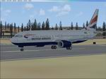
British Airways Boeing 737-800 Textures
(Category: FSX > Civil Jets)
0.83Mb (7419 downloads)
FSX
British Airways Boeing 737-800 Textures,
registration G-DOCN. Textures only for the default B737-800.
Repaint by Paul Kemp. 855K
Posted Jun 23, 2008 14:17 by archive
FSX
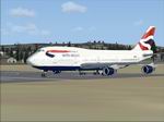
British Airways Boeing 747-400 Textures
(Category: FSX > Civil Jets)
0.86Mb (12080 downloads)
FSX
British Airways Boeing 747-400 Textures,
registration G-CIVE. Textures only for the default B747-400.
Repaint by Paul Kemp. 873K
Posted Jun 23, 2008 14:17 by archive

FSX
Project Opensky A330-300 Airbus House scheme (With and without
SATCOM), Air Canada, Cathay Pacific and Scandinavian Airlines
(SAS - with SATCOM) liveries
(Category: FSX > Civil Jets)
38.98Mb (13263 downloads)
FSX
Project Opensky A330-300 Airbus House scheme (With and without
SATCOM), Air Canada, Cathay Pacific and Scandinavian Airlines
(SAS - with SATCOM) liveries.
Designed to be a competitor to the Boeing 777-200, Airbus Industries
has out done itself creating a beautiful and fuel efficient
flying machine capable of delivering passengers in safety and
comfort well into the 21st Century and possibly beyond. All
textures have been modified in DXT-3 format for crisp visuals
without comprimising frame rates. The panel has been aliased
to the FS-X default Airbus A321 (due to no A330 panel available
for FS-X to date). A magnificient A330 sound package by Steven
Persson has been included for authenticity. Assembled &
Presented by Brian C. Selb. 40MB
Posted Jun 23, 2008 14:17 by archive