


All Files > Page 2885
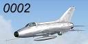
MiG-21 F-13 Package Update
(Category: FSX > Military)
0.01Mb (7295 downloads)
I saw this Mig-21 F-13 by Ivan Jurcaga with an amazing sound set and model. The VC is okay, but not fully clickable. I've been reworking .air files and .cfg files for a few demo teams and an Abacus add on pack and decided to do this for fun. It flies much more accurately than the default flight dynamics for the aircraft and I've changed everything from the flight dynamics themselves to the rate of animation and fuel flow.
Required files:
required file
Posted Aug 13, 2009 00:29 by John Corsi
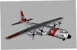
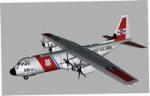
C 130 Hercules US Coast Guard Static plane
(Category: FS Design > Scenery Design Objects)
0.91Mb (5215 downloads)
This is the C130 Hercules for FSX in US Coast Guard Colors as Static Plane to be put in FSX by any object placement tool. The plane was modelled by Guy Diotte.
Posted Aug 12, 2009 23:40 by Guy Diotte
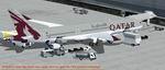
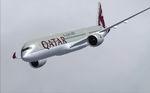
Qatar Airbus A350-900 XWB V2
(Category: FSX > Civil Jets)
2.34Mb (9120 downloads)
FSX Qatar Airbus A350-900 XWB V2. Versions 2 is an all new version of the A350-900 seen at the Paris Air Show 2009, with a new nose, new cockpit windows,new wings and winglets.
This CamSim Version 2 is also including an updated new Animated Ground Servicing (AGS).
Model design and paint by: Camil Valiquette
Posted Aug 12, 2009 18:13 by Camil Valiquette
Qatar Airbus A350-900 XWB V2
(Category: FS2004 > Civil Jets)
5.76Mb (5027 downloads)
FS2004 Qatar Airbus A350-900 XWB V2. Versions 2 is an all new version of the A350-900 seen at the Paris Air Show 2009, with a new nose, new cockpit windows,new wings and winglets.
This CamSim Version 2 is also including three aircrafts with different updated new Animated Ground Servicing (AGS).
Model design and paint by: Camil Valiquette
Posted Aug 12, 2009 18:09 by Camil Valiquette
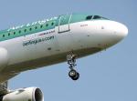
Aer Lingus Cabin Crew Pack for FlightDeck SFX Panel
(Category: FS2004 > Payware)
35.63Mb (1610 downloads)
The following file contains various recorded sounds from Aer Lingus flights which includes safety demos for the a330 and a321, landing announcements at various airports as well as a generic welcome , amongst others.Enjoy.Note , you must have the fantastic FlightDeck SFX Panel
Posted Aug 12, 2009 16:10 by Owen Cannon

Aer Lingus Cabin Crew Pack for FlightDeck SFX Panel
(Category: FS2004 > Payware)
35.63Mb (1414 downloads)
The following file contains various recorded sounds from Aer Lingus flights which includes safety demos for the a330 and a321, landing announcements at various airports as well as a generic welcome , amoungst others.Enjoy.Note , you must have the fantastic FlightDeck SFX Panel
Posted Aug 12, 2009 15:44 by Owen Cannon
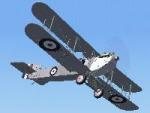
Fairey III D. MkII Wheel version.
(Category: FS2004 > Vintage)
5.97Mb (2114 downloads)
FS2004 Fairey III D. MkII.
A FAA. Spotter/Reconniassance aircraft.
Typical colour scheme, circa. 1924.
Fitted with wheeled undercart.
Remodelled using FSDS v.3.5.1
Ver. 0_5, By Edward Cook
Posted Aug 12, 2009 15:29 by Edward Cook
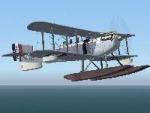
Fairey III D. MkII Floats
(Category: FS2004 > Vintage)
6.29Mb (1680 downloads)
FS2004 Fairey III D. MkII. floatplane.
A FAA. Spotter/Reconniassance aircraft
Typical colour scheme, circa. 1924.
Remodelled using FSDS v5.5.1.
Ver. 0.5, By Edward Cook
Posted Aug 12, 2009 15:27 by Edward Cook
CYRC - Chicoutimi airport, Quebec, Canada
(Category: FSX > Scenery)
4.98Mb (1560 downloads)
CYRC - Chicoutimi airport, Quebec, Canada
Chicoutimi Airport is located in Quebec, North west of CYQB and includes a NDB approach. It provides 3 runways in delta!
I have developped the apron and parking lot including multiple building that the original airport have. Wild life is around and a visual reference should help you find
that airport quite easily! :)
Hope you'll enjoy your stop over in Chicoutimi.
I have included the airport information and charts. By Daniel Louvet
Posted Aug 12, 2009 15:21 by Daniel Louvet
Boeing 747-300 XL Airways
(Category: FS2004 > Civil Jets)
10.31Mb (5623 downloads)
Project Opensky 747-300 XL Airways. Model features High resolution textures (Photoreal), Dynamic flexing wings, Body gear steering, Nose gear steering, Rudder lock, Ground spoilers, Low speed aileron locks at high speed, Fully animated control surfaces, Fully independent suspension, Trim Animation, Opening Passenger Doors, Animated tilting bogies, semi-transparent fan textures [carried over form the -200 series], Rolling wheels, Animated thrust reverser's with reverser block doors, Detailed textures, Full night lighting, Crash affects, Ground Service Vehicles And more. Model Designer Hiroshi Igami/Yosuke Ube. Flight Dynamics Designer Brandon D Henry. Tested by Project Open Sky Members And me. Textures by Ben Jones/Yosuke Ube. Livery by Thomas LP.
Posted Aug 12, 2009 15:19 by Thomas LP