


All Files > Page 1401
B-24J Textures
(Category: CFS1 > Aircraft)
0.06Mb (279 downloads)
This are B-24j Tweak Textures FOR DEFAULT CFS1 B-24j.
Posted Sep 17, 2013 22:11 by 64FULCRUMFREAK
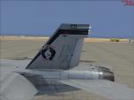
VRS Superbug VFA-94 70th Anniversary Textures
(Category: FSX > Payware)
1.83Mb (248 downloads)
VFA-94 70th Anniversary CO
paint scheme textures for the payware VRS Superbug
Posted Sep 17, 2013 16:52 by Christopher Hammons
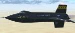
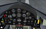
FSX North American X-15
(Category: FSX > Military)
20.53Mb (10831 downloads)
This is an FSX update for Massimo Altieris FS2002 North American X-15. It was the first manned aircraft to cross the gap between the flight in the atmosphere and space flight. It reached speeds of about Mach 6 and became the fastest winged aircraft at the time. It features a new VC and 2D panel and corrected smoke effects. Configuration by Michael Pook.
Posted Sep 17, 2013 13:03 by Michael Pook
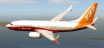
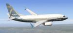
TDS Boeing 737-700 Boeing House Colours "Sunrise" Textures
(Category: FS2004 > Civil Jets)
8.43Mb (868 downloads)
Boeing House Colours "Sunrise" N6267R textures for the TDS Boeing 737-700. G Catena
Required files:
required file
Posted Sep 17, 2013 10:46 by uploader
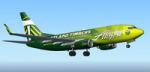
TDS Boeing 737-700 Alaska Airlines Portland Timbers Textures
(Category: FS2004 > Civil Jets)
11.36Mb (766 downloads)
Alaska Airlines Portland Timbers textures for the TDS Boeing 737-700.
Required files:
required file
Posted Sep 17, 2013 10:46 by uploader
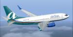
TDS Boeing 737-700 Airtran Textures
(Category: FS2004 > Civil Jets)
10.85Mb (312 downloads)
Airtran Textures for the TDS Boeing 737-700.
Required files:
required file
Posted Sep 17, 2013 10:34 by uploader
TDS Boeing "Max 7" House Livery Textures
(Category: FS2004 > Civil Jets)
9.74Mb (603 downloads)
Boeing "Max 7" House Livery Textures for the TDS Boeing 737-700. G Catena
Required files:
required file
Posted Sep 17, 2013 10:32 by uploader
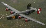
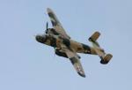
B-25j Desert Textures
(Category: CFS1 > Aircraft)
0.06Mb (209 downloads)
This is B-25j Desert Textures FOR DEFAULT CFS1 B-25j.
Posted Sep 17, 2013 09:01 by 64FULCRUMFREAK
B-25 in Soviet textures
(Category: CFS1 > Aircraft)
0.06Mb (138 downloads)
This is Soviet B-25 Textures FOR DEFAULT CFS1 B-25.
Posted Sep 17, 2013 08:10 by 64FULCRUMFREAK
Do17z2 winter textures
(Category: CFS1 > Aircraft)
0.04Mb (130 downloads)
This is Do17z2 in winter Textures FOR DEFAULT CFS1 Do17z2.
Posted Sep 17, 2013 08:06 by 64FULCRUMFREAK