


All Files > Page 1517
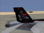
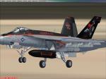
VRS Superbug VFA-147 CAG 2013 Textures
(Category: FSX > Payware)
1.80Mb (411 downloads)
The new 2013 VFA-147 CAG textures for the payware VRS Superbug. Thanks
to tbump34 for the photos.
Posted Feb 22, 2013 19:44 by Chris Hammons
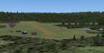
Bengaluru Airport, VOBL, India
(Category: FSX > Scenery)
3.35Mb (2340 downloads)
Bengaluru, also known as the silicon valley of India has one of those Int.airport not depicted in Fsx. VOBL is created solely based on Google Map information. The textures are derived from various internet sites. I've added some textured static ground vehicles.
Posted Feb 22, 2013 14:02 by Ratan Lewis
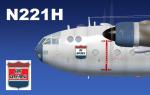
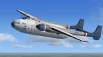
Nord Noratlas Air America N221H Textures
(Category: FSX > Props)
44.38Mb (1340 downloads)
FSX Nord Noratlas repaint textures for Air America N221H, for the wonderful
J.F. Martin Projetnoratlas freeware Nord Noratlas, which you must have
previously installed in FSX. Air America? Noratlas? Hey, just because
they never flew it doesn't mean they never flew it! Screenshots enclosed.
Easy installation. Repaint by Tom Tiedman.
Required files:
required file
Posted Feb 22, 2013 13:08 by Tom Tiedman
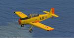
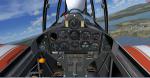
FS2004/FSX Nord Aviation 3202
(Category: FS2004 > Props)
35.41Mb (3651 downloads)
The Nord Aviation 3202 was a 1950s French military trainer aircraft designed and built by Nord Aviation to meet a French Army requirement for a two-seat basic trainer, as a replacement for the biplane Stampe SV.4. Package works in FSX and FS2004 and has VC. By the Restauravia team with a minor mod to make the prop clear in FSX by Mike Lietze
Posted Feb 22, 2013 10:06 by Mike Lietze
Sundridge-South River CPE6
(Category: FSX > Scenery)
10.80Mb (437 downloads)
FSX-only Sundridge-South River CPE6. This is a self-contained package to improve the Sundridge-South River airport scenery. It inlcudes slightly revised runways, plus the hangars, club house and Ron's and Verna's shop. This nice rural airport in the Ontario Near North may not be there for much longer, so here is the simulation for those of us who used it for so many years. For free distribution only. By Fern Marques.
Posted Feb 22, 2013 09:55 by Fern Marques
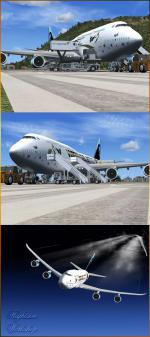
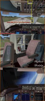
FSX Boeing 747-8i Virgin Galactic Package
(Category: FSX > Civil Jets)
78.88Mb (15549 downloads)
POSKY Boeing 747-8i, painted with the colors of Virgin Galactic. This particular airplane wears the "Virgin Galactic Spaceships texture" wonderful and unique paintscheme includes a dirty look, some stains and signs of humidity just like a real airplane and other body texture fixes by Enrique Cornejo.
Uses the B747-800 Model OSX748V4_GENX(MDL) from Posky, with the New FSX-B747 VC upgrade by Alejandro Rojas Lucena and the FSX-B747 VC textures upgrade. Paintscheme by Enrique Cornejo.
Also I add some pop up gauges windows to the panel.cfg for better and friendlier flights, I hope you enjoy them.
Please read 'My Icons Readme' text and follow the easy steps, I also include Panels images.
I add real smoke in the four engines, more cabin views, realistic cockpit and engines sound & more realistic night VC lights and fuselage night textures by Enrique Cornejo.
I fixed the VC Lights effects, you only have to reset the Instrument panel light dim switch to see night lights inside the cockpit!
Assembled and edited for FSX by Enrique Cornejo
Posted Feb 21, 2013 13:00 by Enrique Cornejo
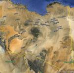
FSX Libya Airfield Locator
(Category: FS Navigation > Flight Simulator Navigation)
2.48Mb (142 downloads)
Tested on Windows XP and Windows 7.
This download adds airfield markers and ICAO id's found in FSX, and overlays them on Google Earth.
This file is for Libya.
There is also a seperate file with a list of basic airfield location details.
i.e: EGBB Birmingham Airport. Birmingham. N52* 27.23' W1* 44.88' alt325.
Also the tidying "My places" in Google Earth, file.
Other locator files to follow.
by Carl Vokes
Posted Feb 21, 2013 10:16 by carl vokes
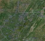
FSX West Virginia Airfield Locator
(Category: FS Navigation > Flight Simulator Navigation)
2.55Mb (94 downloads)
Tested on Windows XP and Windows 7.
This download adds airfield markers and ICAO id's found in FSX, and overlays them on Google Earth.
This file is for West Virginia. USA.
There is also a seperate file with a list of basic airfield location details.
i.e: EGBB Birmingham Airport. Birmingham. N52* 27.23' W1* 44.88' alt325.
Also the tidying "My places" in Google Earth, file.
Other locator files to follow.
by Carl Vokes
Posted Feb 21, 2013 10:13 by carl vokes
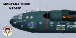
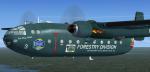
FSX Nord Noratlas Montana DNRC Forestry Division Smokejumper Transport N7549F Textures
(Category: FSX > Props)
35.79Mb (1587 downloads)
FSX Nord Noratlas repaint textures for the wonderful J.F. Martin
Nord Noratlas, which you must have previously installed in FSX.
In memory of the twelve smokejumpers and one forest ranger who
were tragically killed in Montana's Mann Gulch fire, trapped in a
blow up that moved so fast it consumed 3000 acres in ten minutes.
Honoring all of our world's firefighters, this Montana Dept.
of Natural Resources and Conservation (DNRC), Forestry Division Nord
Noratlas smokejumper transport aircraft, N7549F, in dark blue,
incorporating excerpts from the smokejumper's prayer, celebrates the
history and grand traditions of all the smokejumpers, as well as
firefighters everywhere who bravely jump into what all the rest
of us run from. Screenshots enclosed. Easy installation.
Special thanks to designer J.F. Martin at projetnoratlasDOTorangeDOTfr
as well as Rachael over at Sim Outhouse for their assistance and
patience in answering my questions during this repaint process.
By Tom Tiedman.
Required files:
required file
Posted Feb 20, 2013 23:26 by Tom Tiedman
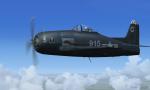
VF-61 F-8 Bearcat
(Category: FSX > Vintage)
6.34Mb (2948 downloads)
This is Alpha Bleu Ciel's Grumman F-8 Bearcat updated For Flight Simulator X.
The U.S. Navy squadron VF-17 The Jolly Rogers was redesignated as VF-61 in 1948
The VF-61 Jolly Rogers flew The Grumman F-8 Bearcat. Here is one of those historical pirate ships created for FSX. This Aircraft has a fully function 2D and 3D cockpit. New flight dynamics, smoke system, New Textures are created in a high gloss. Package includes pictures and History of VF-61 Jolly Rogers. Textures and updates by Mark Rooks.
Posted Feb 20, 2013 21:33 by Mark Fireball Rooks