


All Files > Page 5138
FS2002,
CFS2 and CFS1 Belgian Nieuport 17.
(Category: CFS1 > Aircraft)
2.53Mb (1004 downloads)
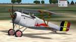
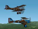
FS2002,
CFS2 and CFS1 Belgian Nieuport 17.
Many of the French, British and Belgian aces began their careers flying
the Nieuport 17. It was a larger, improved version of the Nieuport
11. This plane has a nose gun. It was one of the airplanes from the
Comet squadron, flown by Belgian ace Edmond Thieffry who is credited
with 10 victories. The Belgian Nieuport 17 flies realisticaly with
superb manoeuvrability. New improved model with fully animated moving
parts by Stephan Scholz. Sound.cfg by Christoph Ruhtenberg. New texture,
Air and Dp file by A.F.Scrub. 2.6MB
Posted Jun 10, 2008 11:32 by archive
CFS1,CFS2
and FS2002 Nieuport 17
(Category: CFS1 > Aircraft)
2.51Mb (1203 downloads)
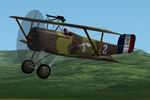
CFS1,CFS2
and FS2002 Nieuport 17,
as flown by René Dorme 1917. The Nieuport 17 was One of the most
successful WW1 biplane fighters. The highly manoeuvrable "Superbébé"
was a larger, improved version of the Nieuport 11. The Nieuport
17 easily outclimbed and outperformed many early German Fighters.This
model had a 120Hp rotary engine and a topwing mounted gun. René
Dorme got 23 victories, with unit N3, when he was killed in action.
New improved model with fully animated moving parts by Stephan Scholz.
Sound.cfg by Christoph Ruhtenberg. New texture, Air and Dp file
by A.F.Scrub. 2.6MB
Update:
Nieuport 17 texture enhancement, René Dorme 1917. Enhanced texture.Just
replace the Nieu17RD.oaf texture by the new one. A.F.Scrub. 51K
Posted Jun 10, 2008 11:32 by archive
CFS
North American ABP-51H Mustang.
(Category: CFS1 > Aircraft)
3.48Mb (885 downloads)
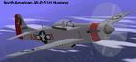
CFS
North American ABP-51H Mustang. The
"H" model was the fastest of the Mustangs to be produced, and is considered,
along with the Republic P-47M Thunderbolt, to be THE FASTEST propeller-driven
aircraft of World War II. Designed to still operate at the higher
altitudes to carry out its original role, I use the air-cooled version
of the original engine. This helps to eliminate the Mustang's vulnerability
to damage, and, as an added bonus, has helped its performance significantly
at lower altitudes. I consider this aircraft a true "add-on", and
NOT a "mod". Includes a second aircraft, a "repaint" of the AB-P-51H,
called the AB-P-51H "Vampire". Author, model, air and damage profile,
textures, and sounds: Michael Priester. 3.5MB
Posted Jun 10, 2008 11:32 by archive
Grumman
F4F-4 WILDCAT For CFS1 and CFS2
(Category: CFS1 > Aircraft)
0.30Mb (680 downloads)
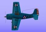
Grumman
F4F-4 WILDCAT For CFS1 and CFS2
This aircraft Nr 17 flew with VF-6 during March 1942. This stubby
little carrier fighter was easy, forgiving, and even fun to fly. It
was Grumman's first modern all-metal monoplane fighter. The Wildcat
was stoutly constructed, well-armored, and well-armed, with the same
six .50-caliber Brownings carried by the Hellcat, Corsair, and Mustang.
The Wildcat's larger wing, relatively more powerful engine combined
with its best traits gave the Wildcat superior turning and diving
ability.The F4F-4 model had a more powerfull engine and was the first
version to have folding wings. Original Designer: Mauro Giacomazzi.
Scasm mdl by Corrado La Posta. Repaint with new Textures, Air and
Dp file by A F Scrub. 308K
Posted Jun 10, 2008 11:32 by archive
CFS1
and CFS2 Royal Aircraft Factory S.E.5, Australian Air Force
(Category: CFS1 > Aircraft)
0.38Mb (836 downloads)
CFS1
and CFS2 Royal Aircraft Factory S.E.5, Australian Air Force
B8392 flown by Lt Frank Currie and RFC A8396 flown by Captain William
Avery "Billy" Bishops in 1917. By Andrew W.Hall, Stephan Scholz and
A.F Scrub. 392K
Posted Jun 10, 2008 11:32 by archive
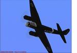
CFS1
Repainted textures only for the RAF662 Ju88A4
(Category: CFS1 > Aircraft)
0.28Mb (258 downloads)
CFS1
Repainted textures only for the RAF662 Ju88A4
for CFS. Roger Lowery's Ju88 is the best CFS Ju88A4. These textures
depict a typical European Ju88A4 in a weathered, battle-weary condition.
Included are details of how to acquire the aircraft and how to use
it as the default JU88 in CFS. Also included is an alternative panel.
If you haven't already got the plane go to the RAF662 website at www.RAF662.com.
Arno Brooks. 285K
Posted Jun 10, 2008 11:32 by archive
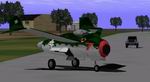
Updated
CFS Blohm und Voss P.212.03 "Strahljager"
(Category: CFS1 > Aircraft)
(1016 downloads)
Updated
CFS Blohm und Voss P.212.03 "Strahljager"
("Jet Fighter") The P.212.03 was Blohm und Voss entry into the Emergency
Fighter Competition to take advantage of the new He S 011 jet engine.
Three prototypes were ordered and construction began in May 1945.
The first aircraft was to make its first flight in August and the
second aircraft was to be ready by September 1945. Of course, the
end of the war ended all construction. Features: realistic Flight
Dynamics, realistic Sound and Panel, realistic Damage Profile, full
moving parts, two liveries: Green Camo and Air Grey. Model, Textures
and Damage Profile by CM Carlson. Panel by Stefan Geißler. Sound by
Bernd Rossner. Flight Dynamics, Modifications and Package by Simone
Prattico'.>>>Updated!
Posted Jun 10, 2008 11:32 by archive
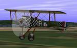
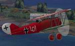
CFS2/CFS
Sopwith Camel.
(Category: CFS1 > Aircraft)
2.51Mb (1051 downloads)
CFS2/CFS
Sopwith Camel.
This aircraft was flown by C.M.McEwen McEwen joined the Canadian Army
in 1916. In 1917, he was seconded to the Royal Flying Corps. He served
in Italy as a Sopwith Camel pilot, scoring 27 victories. He received
the Military Cross (MC) , Distinguished Flying Cross (DFC) and the
Distinguished Flying Cross (DFC) with Bar in September 16, 1918 "For
conspicuous gallantry and devotion to duty in destroying 27 enemy
aeroplanes". Original AFX by Andrew Hall. New enhanced model with
moving parts by Stephan Scholz. Sound.cfg by Christoph Ruhtenberg.
New Panel, Textures, Air and Dp file by A.F.Scrub. 2.6MB
Posted Jun 10, 2008 11:32 by archive
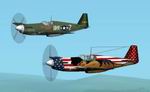
CFS1+CFS2
Mustangs P-51B "Semper Fi" and "The Hun Hunter Texas"
(Category: CFS1 > Aircraft)
2.08Mb (891 downloads)
CFS1+CFS2
Mustangs P-51B "Semper Fi" and "The Hun Hunter Texas".
"Semper Fi" (Always Faithful) is a fictious P51b fighting machine
with exceptional performance and terrible guns. "The Hun Hunter" is
a realistic P51b Mustang as flown by 1st Lieutenant Henry Brown, a
14 victory Ace from 354th Fighter squadron during April 44. A.F.Scrub.
2.1MB
Posted Jun 10, 2008 11:32 by archive
CFS1
WW 1 Pfalz D XII
(Category: CFS1 > Aircraft)
2.43Mb (651 downloads)
CFS1
WW 1 Pfalz D XII
This is one of the last and best German fighters from the great war.
It entered service in 1918 and was the challenger of the Fokker D.VII.
Moving parts, 4 different paint schemes. Bob Pearson's profiles used
for textures. Original Model by JC Kiefer. Adapted for XP windows
with correct Mdl and new Dpfile by A.F.Scrub. 2.5MB
Posted Jun 10, 2008 11:32 by archive