


All Files > Page 1598
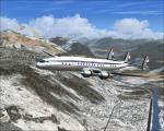
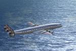
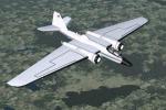
KLM L-1049C Textures
(Category: FSX > Vintage)
4.18Mb (635 downloads)
FSX/FS9 KLM L-1049C Textures for the L-1049G model by Manfred Jahn.
KLM textures by Gary Harper.
Required files:
required file
Posted Oct 20, 2012 23:41 by Gary Harper
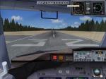
Fix for B737-700 Southwest Florida Radio Altimeter FP_RA55
(Category: FSX > Civil Jets)
0.17Mb (875 downloads)
I would like to apologies for my over sight in the lack of the radio altimeter gauge when I uploaded the Florida_One-B737-700-FSX-3.zip. Just drop the FP_RA55 .cab into the main fsx gauges folder, and if you don´t have the Opensky_nacelle_refl.fx effect just drop into effects folder and that´s it.
Required files:
required file
Posted Oct 20, 2012 18:59 by Enrique Cornejo
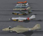
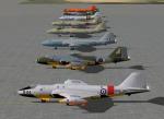
FSX AI Aircraft. English Electric Canberra's
(Category: FSX > Scenery)
38.39Mb (1498 downloads)
FSX AI Aircraft. English Electric
Canberra's B2, PR3, T17A, TT18 and PR9.
PR9's comprise 5 individually numbered
aircraft for my new RAF retro Marham scenery
available in egym_1993_X_1.zip. Paint kit
included. Separate pack for FS9 is available
in: JY_Canberras_AI_FS9_1.zip.
By John Young, Airfield Construction Group.
Posted Oct 20, 2012 14:26 by mike
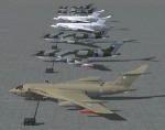
AI Aircraft. Handly Page Victors:
(Category: FSX > Scenery)
30.56Mb (978 downloads)
FSX AI Aircraft. Handly Page Victors:
B2 white+camo, with and without Blue Steel,
K2(Hemp+Camo) and SR2. K2s are 11
individually numbered aircraft for my new
RAF retro Marham scenery that is available
in egym_1993_9_1.zip. K2 model included that
deploys hoses at 18,000 ft and above.
Separate pack for FS9 is available in:
JY_Victors_AI_FS9_1.zip. Paint kit included.
By John Young, Airfield Construction Group.
Posted Oct 20, 2012 12:08 by mike
FSX AI Aircraft. NASA Martin WB-57F AI Canberra's
(Category: FSX > Scenery)
4.40Mb (943 downloads)
FSX AI Aircraft. NASA Martin WB-57F AI
Canberra's. Features the two aircraft
operating from Ellington Field Houston
Texas, plus the earlier paint scheme.
Separate pack in FS9 native code is in:
JY_WB57F_AI_FS9_1.zip.
By John Young, Airfield Construction Group.
Posted Oct 20, 2012 11:58 by mike
FS2004 AI Aircraft. English Electric Canberra's
(Category: FS2004 > Scenery)
33.13Mb (825 downloads)
FS2004 AI Aircraft. English Electric
Canberra's B2, PR3, T17A, TT18 and PR9.
PR9's comprise 5 individually numbered
aircraft for my retro RAF Marham scenery
available in egym_1993_9_1.zip. Paint kit
included. Separate pack in FSX native code
is in: JY_Canberras_AI_FSX_1.zip.
By John Young, Airfield Construction Group.
Posted Oct 20, 2012 11:51 by mike
AI Aircraft. NASA Martin WB-57F
(Category: FS2004 > Scenery)
2.16Mb (438 downloads)
FS2004 AI Aircraft. NASA Martin WB-57F
AI Canberra's. Features the two aircraft
operating from Ellington Field Houston
Texas, plus the earlier paint scheme.
Separate pack in FSX native code is in:
JY_WB57F_AI_FSX_1.zip.
By John Young, Airfield Construction Group.
Posted Oct 20, 2012 11:49 by mike
FS2004 AI Aircraft. Handly Page Victors
(Category: FS2004 > Scenery)
24.30Mb (883 downloads)
FS2004 AI Aircraft. Handly Page Victors:
B2 white+camo, with and without Blue Steel,
K2(Hemp+Camo) and SR2. K2s are 11
individually numbered aircraft for my new
RAF retro Marham scenery that is available
in egym_1993_9_1.zip. K2 model included that
deploys hoses at 18,000 ft and above.
Separate pack in FSX native code is in:
JY_Victors_AI_FSX_1.zip. Paint kit included.
By John Young, Airfield Construction Group.
Posted Oct 20, 2012 11:34 by mike
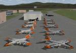
FS2004 AI Aircraft. Martin B-57 AI Canberras.
(Category: FS2004 > Scenery)
33.79Mb (610 downloads)
FS2004 AI Aircraft. Martin B-57 AI Canberras.
Features 18 aircraft of the 134th DSES,
Vermont ANG, circa 1981, one aircraft of the
Kansas ANG and one from the 13th TBS. AFCAD
for Burlington(KBTV)with flight line hangar
is included along with a circuit traffic file
for the 18 aircraft based there at the time.
A separate pack in FSX native code is in:
JY_B57_AI_FSX_1.zip.
By John Young, Airfield Construction Group.
Posted Oct 20, 2012 11:12 by mike
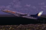
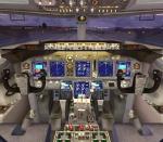
Boeing 737-800 Jet Airways with Advanced VC
(Category: FSX > Civil Jets)
16.42Mb (7875 downloads)
Boeing 737-800 Jet Airways, India's 2nd largest airline. Model by Project Opensky. Upgraded VC by Alejandro Rojas Lucenda, includes working wipers (right mouse click on switch) with rain effect. Switches for LCD Screens, EICAS, PFD, MFT. Autobrake switch. Opening pilots window. Cabin Lights switch. Realistic FMC. Ground Proximity Warning System (GPWS). Update and textures by ricardo_tv.
Enjoy
Posted Oct 19, 2012 16:38 by ricardo_tv