


All Files > Page 4319
FS2004 DC-3 Twin Panel Package in 3 Variations:
(Category: FS2004 > Panels)
5.48Mb (4222 downloads)
FS2004
DC-3 Twin Panel Package in 3 Variations:
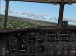
This package includes: 1. The default DC-3 panel with the addition
of a co-pilot option which can be toggled inflight. All pop-up
windows that are available on the Captain's side are also available
from the First Officer position. Other small modifications,
including a cleaned up main bitmap by Andy Hatcher. 2. The default
panel lowered to give better visibility, also with a switchable
co-pilot position. 3. A modified, more contemporary panel with
VOR1, RMI and VOR2 gauges. Co-pilot position can be switched
inflight. In addition to standard pop-up windows, this panel
uses Bendix King radios, has optionally overlaid digital readouts
for all key instruments and two flight timers, all of which
can be accessed from both seating positions. Replacement gauges
flow through to the VC. All panels are darkened slightly for
more realism, have modified night lighting and other additions
such as an electrical panel on the FO's side. By Mark Beaumont.
. File name: DC3_PAN.ZIP. 5.6MB
Posted Jun 23, 2008 14:27 by archive
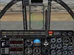
FS2004
Northrop/Canadair VF-5D "Zancudo" Panel.
(Category: FS2004 > Panels)
2.62Mb (2531 downloads)
FS2004
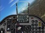
Northrop/Canadair VF-5D "Zancudo" Panel.
Custom panel for VF-5 (that´s the code for the F-5B in the Venezuelan
AirForce) HUD featured by:Claudio Sanchez. 2.7MB
Posted Jun 23, 2008 14:27 by archive
FS2004
C-123 "Provider" Panel II.
(Category: FS2004 > Panels)
0.84Mb (3580 downloads)
FS2004
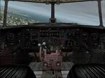
C-123 "Provider" Panel II.
"This is the V2.0 of my photorealistic C123 provider panel
!!! Ihad to do this since the c123 of Vladimir Zhyhulskiy doesn't
include one ...includes many updates over the original panel.
thanks for al those downloads of the original - online tested
- "FS2004 only" Made in cfgedit By: Claudio Sanchez. 860K
Posted Jun 23, 2008 14:27 by archive
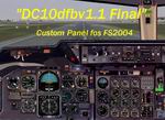
FS2004
McDonnel-Douglas DC-10 (KC-10)
(Category: FS2004 > Panels)
10.59Mb (6536 downloads)
FS2004
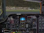
McDonnel-Douglas DC-10 (KC-10)
Custom Panel for Microsoft Flight Simulator 9 (FS2004). Main
panel .bmp and positioning of the gauges as per photos of
the real flightdeck. * New and improved overhead panel and
gauges. If you move your mouse over a switch and it will let
you click it, it probably does what the photo-real panel say's
it does! (pretty cool, huh?!) * Added a couple cool sounds
like an altitude horn, go get me some coffee (and step on
it!!....just kidding!), T.O. Calls, Approach calls, et.,al.
*Added Lee Hetherington's IVSI/TCAS gauge, Built by: Dale
Britton. 12MB.
Further
Files Required
Sounds
Pack: 8.5MB
Gauges
Pack 1: 4.3MB
Gauges
Pack 2: 4.7MB
Gauges
Pack 3: 5.5MB
Gauges
Pack 4: 3.6MB
Posted Jun 23, 2008 14:27 by archive
FS2004
OV-10 "Bronco" Panel
(Category: FS2004 > Panels)
0.39Mb (2107 downloads)
FS2004
OV-10 "Bronco" Panel
I still asking myself why nobody had done this before!!! ...
this is a modification of the original panel (the one that comes
with the "Tim Piglet Conrad" model for CFS) ---it adds AP,HUD,"Nav/GPS"switch
to the panel--- so, now its more enjoyable to travel with this
aircraft (also works in fs2002) - "cfgedited" by Claudio Sanchez.
401K
Posted Jun 23, 2008 14:27 by archive
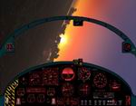
FS2004
Alternate Twin-Jet Panel for Chuck Dome's Supersonic MiG-AT4
trainer
(Category: FS2004 > Panels)
1.17Mb (1093 downloads)
FS2004
Alternate Twin-Jet Panel for Chuck Dome's Supersonic MiG-AT4
trainer
(aircraft found here).
Uses FS9's Garmin 295 in separate window. A fully functional,
retro-style, IMC-capable panel, devoid of glass cockpit systems
and extraneous eye candy. Russian gauges lend an authentic feel.
Offers high outside visibility, as promised by exterior looks
at the aircraft. Framerate friendly, best at 1280x1024. 2-D
panel only, no virtual cockpit. By Gary Smith. 1.2MB
Posted Jun 23, 2008 14:27 by archive
FS2004
King Air All Glass Panel.
(Category: FS2004 > Panels)
0.54Mb (1844 downloads)
FS2004
King Air All Glass Panel.
My simplified interpretation of the Collins Glass panel modification
of the King Air panel, recently featured in the November edition
of FLYING magazine. Utilizes all default gauges,and includes
all of the necessary simicons and Ernie Alston's wonderful RNWY
INFO gauge. By Alex Christoff. 560K
Posted Jun 23, 2008 14:27 by archive
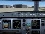
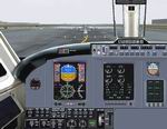
FS
2004 Airbus A-320 panel Version 1.
(Category: FS2004 > Panels)
1.35Mb (11258 downloads)
FS
2004 Airbus A-320 panel Version 1.
This panel was made based on photos of the actual cockpit and
has customized gauges specifically designed for it. By Hector
Molina. 1.4MB
Posted Jun 23, 2008 14:27 by archive
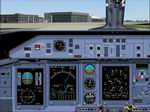
FS2004
Dash 8-400 panel Version 3
(Category: FS2004 > Panels)
1.58Mb (13544 downloads)
FS2004
Dash 8-400 panel Version 3
This panel was designed based on actual Dash 8-400 photos. All
gauges were recompiled, improved and adapted to work with FS2004.
This is a complete package. You don't need previous versions.
By Hector Molina. 1.6MB
Posted Jun 23, 2008 14:27 by archive
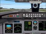
FS2004
Canadair Regional Jet panel Version 3
(Category: FS2004 > Panels)
1.33Mb (6124 downloads)
FS2004
Canadair Regional Jet panel Version 3.
This panel was designed based on actual CRJ photos. All gauges
were recompiled and addapted to FS2004. This is a complete package.
You don't need previous version. By Hector Molina. 1.3MB
Posted Jun 23, 2008 14:27 by archive