


All Files > Page 1290
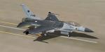

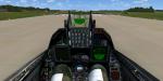
Lockheed Martin F-16 RNALF Solo Display 2014-2015
(Category: FSX > Military)
65.53Mb (6754 downloads)
This is the new scheme of the RNLAF F-16 Demoteam. The orange lion has bin painted grey, and this one is going to replace him. Kirk Ollson Viper model included. Also the updated VC by Danny Garnier, smoke, flares, and afterburner are attached. Repaint by: Mees Jansen
Posted Apr 27, 2014 01:49 by Mees Jansen
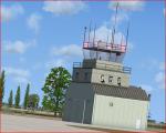
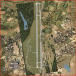
EDAV-Finow, Germany (Updated)
(Category: FSX > Scenery)
0.09Mb (662 downloads)
EDAV Finow Airport in Germany. Flugplatz Finow airport is located in the city of Eberswalde in Germany. Used originally as a WW2 airport, it is now open to GA and some heavier traffic. (version 1.1)
Posted Apr 27, 2014 00:34 by Eric W.
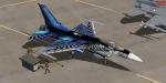
F-16 Demopack vol.3 BAF Solo Display 2011
(Category: FSX > Military)
65.36Mb (5743 downloads)
This is the 3rd demopack, and now containing an better and much detailed texture of the BAf Solo Display vortex jet of 2011. Also model, flares, Afterburner, updated VC by Danny Garnier, and smoke are included. Repaint by: Mees Jansen (LRI)
Posted Apr 26, 2014 18:53 by Mees Jansen
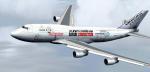
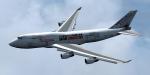
Posky Boeing 747-412BCF Martinair Safari Connection
(Category: FSX > Civil Jets)
51.24Mb (2861 downloads)
This is the Project Opensky 747-412BCF in the Safari Connection livery. Safari Connection is an association between: Kenya Airways, KLM, Airfrance, And Marinair. Model Included. Also black contrails like real :) Repaint by: Mees Jansen (LRI)
Posted Apr 26, 2014 12:57 by Mees Jansen
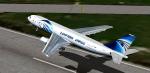
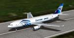
Thomas Ruth Airbus A300-600F Egyptair Cargo
(Category: FSX > Civil Jets)
64.89Mb (5516 downloads)
This is the A300-60F of Egyptair Cargo made with tow variants of repaints including the reg. SU-GAS/SU-GAY. Thomas Ruth's model included. Repainted by: Mees Jansen (LRI)
Posted Apr 26, 2014 12:12 by Mees Jansen
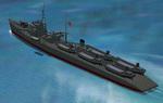
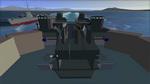
FSX Pilotable WWII IJN Landing Ship
(Category: FSX > Misc)
4.20Mb (652 downloads)
FSX Features for a pilotable japanese landing ship No1. This is a very detailed CFS2 WWII warship made by Masazumi Kaneko/Usio no Ibuki in a high quality. This addon provides a pilotable ship with 2D-panel as navigation bridge, VC- and more added views plus special effects. Two external plus sixteen decks views let you explore the ship, carrying five LCM boats. Bitmaps and configuration by Erwin Welker.
Posted Apr 26, 2014 06:09 by Erwin Welker
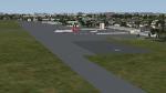
Kotoka Intl Airport, Accra, Ghana
(Category: FSX > Scenery)
0.74Mb (668 downloads)
This is Kotoka Intl airport in Accra Ghana. Made from default FSX libraries. Acceleration will give the best results.
Posted Apr 26, 2014 02:36 by Jacques Botha
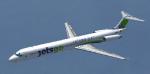
FSX Mc Donnell Douglas MD83
(Category: FSX > Civil Jets)
5.68Mb (4630 downloads)
The MD 83 is an evolution of the popular DC 9 with a new avionics and a biggest capacity. Original aircraft by SGA. Adaptation to FSX, 2D panels and gauges for wide and standard screen (no VC) by Philippe Wallaert. See instructions in the readme.txt file. Credit: SGA for the original aircraft.
Posted Apr 25, 2014 12:13 by Philippe Wallaert


10M Mesh for Easter Island/ Pascua, Chile
(Category: FSX > Terrain Mesh)
0.08Mb (1819 downloads)
10M Mesh for Easter Island/ Pascua, Chile. Easter Island is a Polynesian island in the southeastern Pacific Ocean, at the southeasternmost point of the Polynesian Triangle. Easter Island is famous for its 887 extant monumental statues, called moai, created by the early Rapa Nui people.
Posted Apr 25, 2014 11:56 by juan30005

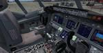
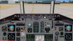
Boeing 737-900ER Lion Air 50th Aircraft Package
(Category: FSX > Civil Jets)
105.05Mb (11666 downloads)
FSX Project Opensky Lion Air 737-900ER - Blended Winglet - 50th aircraft Package with Enhanced VC
Model by Project Opensky.
with advanced 737-800 VC added. Includes utility for ground services, Passenger bus, cargo, 2 stairs, refuelling truck etc (find it under - Views - Instrument panel - Util)
The wonderful Boeing 737-900 from Posky will be enjoyed by many more people who do not know how to install a VC into a FSX native model.
The VC is the Alejandro Rojas Lucena/FSND fantastic revised Boeing 737-800 VC model. This VC model includes Working wipers (right mouse click on switch) with rain effect. Switches for LCD Screens, EICAS, PFD, MFT. Autobrake switch. Opening pilots window. Cabin Lights switch. Realistic FMC. Ground Proximity Warning System (GPWS), More Realistic night VC textures. There are custom Boeing sounds included for that extra realism.
Textures by uniknown - but thank you. Credits to you.
Model is not modified in any way. Just the VC added and aircraft.cfg edited to allow correct VC views.
Posky wonderful native FSX Boeing 737-900 w model. See VC docs to get the best out of the VC and FMC.
Assembled, prepared & tested for FSX by Chris Evans.
Posted Apr 25, 2014 09:47 by chris evans