


All Files > Page 1456

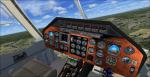
Bell 430 Updated Package
(Category: FSX > Helicopters)
49.28Mb (9006 downloads)
I updated the Ben Batey FSX Gmax Bell 430. Included are the original 14 textures, both wheel and skid models, the Brad Stolte FSX Acceleration Gmax Bell 430 Lights, the David Grindele FSX Northeast Airlines City Hopper Bell 430 texture plus 2D and VC panels.
Posted Jun 16, 2013 04:48 by Michael E. Roberts
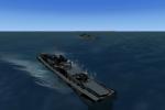
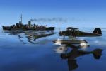
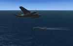
FSX Naval Expansion VIII Kreigsmarine Coastal Forces
(Category: FSX > Misc)
8.86Mb (857 downloads)
The backbone of Kreigsmarine coastal forces, S-Boots and Marinefharprahms carried heavy AAA/ASUW armament, and served in every theater. Maritime pilots learned that these innocuous little craft could punch far above their weight.
Usio's fine S-13 class S-boat, converted to FSX, and a number of versions of the ubiquitous F-lighter, for FSX and AICarriers2.
Posted Jun 16, 2013 04:09 by Lazarus
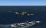
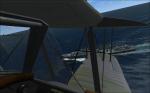
FSX Naval Expansion VII Flower Class Corvettes
(Category: FSX > Misc)
4.72Mb (657 downloads)
The Flower class was the mainstay of the RCN and RN's North Atlantic Campaign.
Slow, wet, and said to 'roll and pitch violently on wet grass', the Flower class
bore the brunt of the Convoy battles during the dark days of U-Boat war, and held the
line untill late 1943 when CVE Hunter Killer groups, VLA maritime aircraft and highly capable
River class Frigates began to relieve the tiny ships. Slower than and out-gunned by a surfaced U-boat,
The Flowers suffered heavy losses, but won the Battle of the Atlantic.
In attached effects and no effects versions. For AICarriers2 or other traffic compilers.
by Lazarus
Posted Jun 16, 2013 03:27 by Lazarus
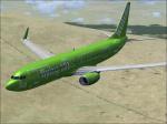
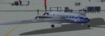
Posky Flight 101 Package
(Category: FSX > Civil Jets)
68.63Mb (2845 downloads)
For the Kulula fan that isn't big on default aircraft, here is a Posky 737-800 with Kulula Flight 101 repaint for FSX. Includes Alejandro Rojas' enhanced VC, textures by Colin Lowe & Project Opensky CFM56-7B Soundset. Assembled for FSX by Dave/1olehippy.
Posted Jun 16, 2013 03:00 by Dave Rocholl
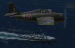
FSX Naval Expansion VI Usio's Royal Navy Vol I
(Category: FSX > Misc)
7.15Mb (475 downloads)
HMS 'L' class Destroyers Lance and Lively.
Usio's fabulous CFS2 ships, converted to FSX
standard with attached effects. No effects version included. For AICarriers2 or other traffic compilers.
Conversion to FSX by Lazarus
Posted Jun 16, 2013 02:57 by Lazarus
FS2004 Driessen D-III - unknown Flying Wing
(Category: FS2004 > Vintage)
16.76Mb (1583 downloads)
The Driessen Flying Wing was the winning contender in a late 1939 competition for a possible K.L.M.long range passenger/mail aircraft.
The aircraft had three 870hp Jumo 205 with three-bladed, metal propellers.
Dimensions: Length: 1.5 m, Wingspan: 34 m, Height: 3.70 m
Due to WWII, this design never reached the hardware stadium.
Posted Jun 16, 2013 02:00 by Andreas Becker
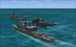
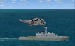
FSX HMCS DDH-DDG 280 Tribal Class Destroyer
(Category: FSX > Misc)
6.81Mb (1163 downloads)
The Iroquois-class destroyers, also known as Tribal class,are a class of four helicopter-carrying,
guided missile destroyers of the Royal Canadian Navy. Designed in 1964-68,and launched from 1972,
they were originally fitted out for anti-submarine warfare,
but a major MLU in the 1990s(Tribal Update Modification Program)
overhauled them for area-anti-aircraft defence. The ships were the first large combatants
exclusively powered by gas turbines, and in contrast to similar Destroyer classes of the day,
had significantly larger aviation spaces and command and control capabilites, often serving
as the NATO STANFORLANT Flagships.
The class had a profound influence on the design of the USN's Spruance class Destroyer and subsequent
classes of Western Destroyers.
This is my take on the -280 class ships, in all 3 major configurations. The ships are landable, and
are offered in attached effects and no effects versions. See Readme file.
Posted Jun 15, 2013 16:08 by Lazarus
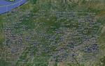
FSX Pennsylvania Airfield Locator
(Category: FS Navigation > Flight Simulator Navigation)
2.69Mb (91 downloads)
Tested on Windows XP and Windows 7.
This download adds airfield markers and ICAO id's found in FSX, and overlays them on Google Earth.
This file is for Pennsylvania. USA.
There is also a seperate file with a list of basic airfield location details.
i.e: EGBB Birmingham Airport. Birmingham. N52* 27.23' W1* 44.88' alt325.
Also the tidying "My places" in Google Earth, file.
Other locator files to follow.
by Carl Vokes
Posted Jun 15, 2013 15:46 by carl vokes
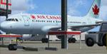
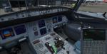
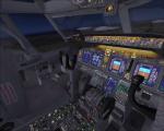
Airbus A319-111 Air Canada Package
(Category: FSX > Civil Jets)
51.27Mb (11484 downloads)
Airbus A319-111 Air Canada C-GBIA for FSX. Includes enhanced default A321 VC
with improved gauges plus popup FMC, GPWS callouts. Custom CFM sounds. Also
added jetway configs (Ctrl J).Model by Project Airbus. Textures by unknown.
Assembled and edited for FSX by Chris Evans
Posted Jun 15, 2013 11:17 by Chris Evans

Aeropuerto La Paloma MNLP
(Category: FS2004 > Scenery)
0.02Mb (437 downloads)
Aeropuerto La Paloma, Isla Ometepe, Nicaragua
MNLP
Posted Jun 15, 2013 11:11 by Alberto Thomas