


All Files > Page 1640
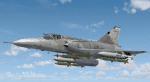
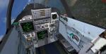
Cheetah C Package
(Category: FS2004 > Military)
31.11Mb (6245 downloads)
The Atlas Cheetah is a fighter aircraft of the South African Air Force. It is a major upgrade of the Dassault Mirage III. Three different variants were created, the dual-seat Cheetah D, and the single-seat Cheetah E and Cheetah C. The Cheetahs have been retired and was replaced by Saab JAS-39 Gripens. This package contains an entirely new visual model and the airfile has been redone to improve the flight dynamics of the aircraft. It includes one model with the choice of multiple weapon configurations, custom sounds, and panel with aircraft specific gauges, and easy-to-read clickable virtual cockpit. It also features a working radar, camera simulated gauges, a new MFD, new nav instruments, drag chute and sound effects. It also includes a normal and wide screen panel. Thinus Pretorius
Posted Aug 7, 2012 11:18 by Thinus Pretorius
Curtiss Reid Rambler MK.III
(Category: FSX > Vintage)
38.23Mb (3638 downloads)
Curtiss Reid Rambler MK.III Flown in the 1931 Kings Cup Air Race (Placed 13th) used as a training aircraft by the Canadian Airforce. Full animations, 3D gauges and Baked Textures. By Craig Richardson
Posted Aug 7, 2012 02:39 by df
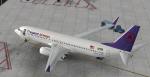
Frequent Airways Boeing 737-800 Textures
(Category: FSX > Civil Jets)
4.05Mb (444 downloads)
Frequent Airways Boeing 737-800 Textures for the default FSX B737. Made by Alex Parker. I made this for my virtual Airline, and decided to let everyone have it.
Posted Aug 6, 2012 22:19 by Alex Parker

FS2004 Extra-300SX
(Category: FS2004 > Props)
0.41Mb (1252 downloads)
The default aerobatics plane,
stand-alone aircraft.
Textured by Stuart Willows,
reworked FD by George Csillag
Posted Aug 6, 2012 19:34 by George Csillag
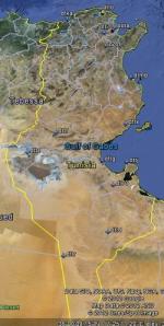
FSX Tunisia Airfield Locator
(Category: FS Navigation > Flight Simulator Navigation)
2.63Mb (262 downloads)
Tested on Windows XP and Windows 7.
This download adds airfield markers and ICAO id's found in FSX, and overlays them on Google Earth.
This file is for Tunisia.
There is also a seperate file with a list of basic airfield location details.
i.e: EGBB Birmingham Airport. Birmingham. N52* 27.23' W1* 44.88' alt325.
Also the tidying "My places" in Google Earth, file.
Other locator files to follow.
by Carl Vokes
Posted Aug 6, 2012 13:32 by carl vokes
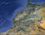
FSX Morocco Airfield Locator
(Category: FS Navigation > Flight Simulator Navigation)
2.77Mb (208 downloads)
Tested on Windows XP and Windows 7.
This download adds airfield markers and ICAO id's found in FSX, and overlays them on Google Earth.
This file is for Morocco.
There is also a seperate file with a list of basic airfield location details.
i.e: EGBB Birmingham Airport. Birmingham. N52* 27.23' W1* 44.88' alt325.
Also the tidying "My places" in Google Earth, file.
Other locator files to follow.
by Carl Vokes
Posted Aug 6, 2012 13:30 by carl vokes
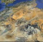
FSX Algeria Airfield Locator
(Category: FS Navigation > Flight Simulator Navigation)
2.75Mb (235 downloads)
Tested on Windows XP and Windows 7.
This download adds airfield markers and ICAO id's found in FSX, and overlays them on Google Earth.
This file is for Algeria
There is also a seperate file with a list of basic airfield location details.
i.e: EGBB Birmingham Airport. Birmingham. N52* 27.23' W1* 44.88' alt325.
Also the tidying "My places" in Google Earth, file.
Other locator files to follow.
by Carl Vokes
Posted Aug 6, 2012 13:28 by carl vokes
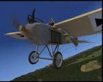
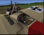
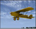
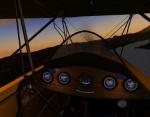
Jeannin Taube Packge
(Category: FSX > Vintage)
14.38Mb (3219 downloads)
Jeannin Taube for FSX. Full animations, 3D gauges and Baked Textures. The Etrich Taube, also known by the names of the various manufacturers who build versions of the type, such as the Rumpler Taube, was a pre-World War I monoplane aircraft. It was the first mass-produced military plane in Germany. As Imperial Germany's first practical military aircraft, the Taube ("dove") was used for virtually all military aircraft applications, as a fighter, bomber, surveillance aircraft and trainer from 1910 until the start of World War I in August 1914. By Craig Richardson
Posted Aug 6, 2012 11:52 by uploader
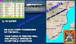
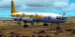
East Africa Cargo Airways
(Category: FSX > Missions)
0.69Mb (4041 downloads)
Memo To: YOU Subject: Prove your Resume --In order to prove the stuff you sent to our honorable Company in the way of a 'Captain Resume', you will make your first flight with us in the 'Babaloo', the IL-18 at the end of the field. You will be carrying some delicate cargo, according to the manifest--Not very Legal rotting alligator skins, 3000 baby snakes of all kinds, 200 boxes of Terminator eggs, 100 boxes of 1940 silk stockings, 4000 shoes en need of repair from Bulgaria, 35 drums of hot water and some 600 dozens of not well painted oil paints from varios 'artists' of old Yugoslavia---As indicated you will leave our home base at Dire Dawa International at 5:43 AM and proceed according to plan. Weather is lousy at this time of the year so take your rubber shoes. Remember to help unload as you stop to deliver the merchandise in the different 'airports' (joke). That's it. Take your breakfast with you and have a fun flight. Your Chief Pilot and boss. Eugene Korkolof
Posted Aug 6, 2012 10:55 by Gera Godoy Canova
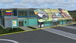
Puerto Ayacucho Airport (SVPA), Venezuela
(Category: FSX > Scenery)
54.74Mb (1266 downloads)
Low-capacity airport mostly used by tourist agencies with
locations in Amazonas state, although it's used as a terminal
for the armed forces and security agencies of the state due
to its proximity to the Colombian border
With photo-terrain scenery from satellite imagery
of Yahoo Satellite.
Not compatible with versions prior to FSX.
This scenery includes terminal building with realistic
textures from images obtained from Internet.
Also includes a friendly Auto-Install.
Posted Aug 6, 2012 08:25 by David Maldonado