


All Files > Page 1651
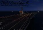
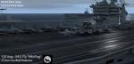
AI Carriers 2 - Carrier Group
(Category: FSX > Scenery)
0.00Mb (4467 downloads)
Just somthing i came up with within Aicarriers2. Instead of one carrier you can now have 5 carriers. 2 have crowded decks. There are also cruisers and destroyers. Requires AI Carriers 2
Posted Jul 16, 2012 04:21 by Dominic Monaco - Fsx Gamespy EASST9
Blue Angels FSX Splashscreen
(Category: Videos/Splashscreens > Splashscreens)
0.79Mb (338 downloads)
This is a U.S. Navy Blue Angels splashscreen for FSX. The splashscreen is what appears before the game itself. I have included a backup file and instructions.
Posted Jul 15, 2012 23:19 by nickthatch12
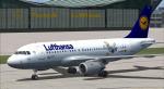
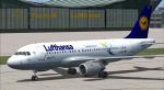
Airbus A319 Lufthansa Package
(Category: FSX > Civil Jets)
73.98Mb (14734 downloads)
Project Airbus A319 Lufthansa D-AILU for FSX.
Includes two different paints of the Lufthansa "LU"
and default VC, upgraded by Jim Fly.
Posted Jul 15, 2012 07:46 by Jim Fly
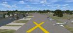
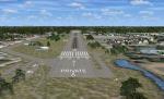
Spruce Creek Fly-in Community, Florida
(Category: FSX > Scenery)
5.31Mb (2162 downloads)
Spruce Creek Fly-in Community (7FL6)
Touted as the worlds most famous residential airpark, this airfield resides within the Daytona Beach International Airport (KDAB) controlled airspace. More information is available at www.7fl6.com. The scenery includes photo landclass changes, rework of the runway, taxiways, aprons and parking; custom scenery objects and placement of library objects. Scenery in this package is based on Virtual Earth (Bing) and Google Earth imagery and photos taken locally. The package includes airport arrival-departure procedures published by the Fly-in and scenery associated with the VFR "Tank Departure". By: Art Poole
Posted Jul 15, 2012 07:44 by uploader
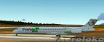
Maddog MD82 Trawel Fly Textures
(Category: FS2004 > Payware)
12.63Mb (369 downloads)
TRAWEL FLY Reg. YR-HBE textures for the payware Maddog MD80
Posted Jul 14, 2012 22:40 by Trino Rojas

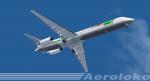
Boeing B737-800 TAM Textures
(Category: FSX > Civil Jets)
3.10Mb (2336 downloads)
New livery of TAM Linhas Aereas, the national carrier of Brazil. Textures for the default FSX B737-800.
Posted Jul 14, 2012 20:53 by good textures
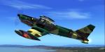
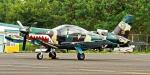
Philippine Air Force SF260 17th Attack Squadron (Jaguars)
(Category: FS2004 > Military)
2.39Mb (1813 downloads)
The mission of the 15th Strike Wing is to conduct tactical air operations in support of Armed Forces of the Philippines units. The unit is headquartered at Danilo Atienza Air Base, Sangley Point, Cavite, just outside the capital Manila. 17th Attack Squadron (Jaguars) - based at Sangley Point, Cavite. 25th Attack Squadron (Lobos) - popularly known as the LOBOS, was re-manned into 25th Composite Attack Squadron based at 3rd Tactical Operations Wing, Edwin Andrews Air Base, Zamboanga City. Aircraft w/ VC Panel by : Marco Spada Aircraft: visual and flight model by: Giovanni Clemente Repainted by: Gerard G. Olvis
Posted Jul 14, 2012 16:17 by Gerard G. Olvis
FSX - Blue User Interface replacement
(Category: FSX > Misc)
1.80Mb (3022 downloads)
Graphics replacement for FSX UI (user interface). See readme for further information.(as always back up any files before replacing)
Posted Jul 14, 2012 12:17 by Jiri Soukup
JT8D Soundpack
(Category: FS Sounds > Flight Simulator Sounds)
64.33Mb (5479 downloads)
Finally, there's a JT8D soundpack with sonecones! This is a must for any pilot of an aircraft powered by the JT8Ds. Enjoy!
Posted Jul 14, 2012 00:14 by Brandon G.

FS2004/FSX United Short Range Traffic with complete sound
(Category: FSX > Scenery)
9.58Mb (1613 downloads)
FS2004/FSX United Short Range Traffic with complete sound
Posted Jul 13, 2012 18:53 by Edriann Nazareth