


All Files > Page 4319
FS2004/2002
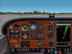
Cessna 182 Woodgrain Panel.
(Category: FS2004 > Panels)
1.77Mb (3296 downloads)
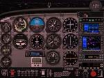
FS2004/2002
Cessna 182 Woodgrain Panel.
This is a photo real replacement panel for the def. Cessna 182
It has a wood grain finish in the main panel, and I have included
a bitmap file for the VC panel wich will match the main panel.
The main panel has Luís ad Costa Pereira M4000! radar gauge
built in to it. Made by Kenny Fox 1.8MB
Posted Jun 23, 2008 14:26 by archive
FS2004/2002
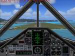
SR-71 Blackbird Panel
(Category: FS2004 > Panels)
0.91Mb (8302 downloads)
FS2004/2002
SR-71 Blackbird Panel:
I have modified the bit map for the SR-71 panel by Michel Polski
so it has a bit better forward view. I have added an autopilot,
GPS, and have changed, removed, or added, other gauges. The
name of the person that uploaded it is Francisco Moreno, but
the name inside the panel.cfg is Michel Polski. This is the
complete panel & the gauges. Updated by Bob Chicilo. 934K
Posted Jun 23, 2008 14:26 by archive
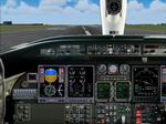
FS2004
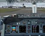
Boeing 738 NG Panel
(Category: FS2004 > Panels)
8.66Mb (8179 downloads)
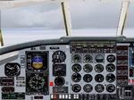
FS2004
Boeing 738 NG Panel
This is photo-realistic and containts a real-life Main Panel,
Radio Stack, Throttle Console and an Overhead Panel. It should
make your longer flights somewhat more enjoyable. . Capt.
Rad J Yarjan.
Part
2: Gauges. 4.6MB
Posted Jun 23, 2008 14:26 by archive
FS2004/2002
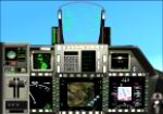
F-22 Panel
(Category: FS2004 > Panels)
4.99Mb (5285 downloads)
FS2004/2002
F-22 Panel
with several new features including an FLR mode, moving terrain
map, animated HUD targetball, and many many more. Included are
lots of custom gauges giving I hope, a nice feel for the unique
aircraft and panel. Assembeled and presented by Roger "Maddog"
Gaylor. 5.1MB
Posted Jun 23, 2008 14:26 by archive
FS2004
LearJet 45 Panel.
(Category: FS2004 > Panels)
1.93Mb (10040 downloads)
FS2004
LearJet 45 Panel.
New panel for default Learjet 45 (or any Lear 45), very realistic,
based on a real photo reworked by Marco Spada. Uses default
and third party gauges. Panel by Marco Spada. 2MB
Posted Jun 23, 2008 14:26 by archive
FS2004
Bombardier CRJ-700 Panel.
(Category: FS2004 > Panels)
6.28Mb (5886 downloads)
FS2004
Bombardier CRJ-700 Panel.
Bitmaps and gauge artwork by Marco Spada. All bitmaps are based
on real photos. Complete with Hud; Pedestal, Overhead and Yoke.
Custom gauges made by various authors. Marco Spada. 6.4MB
Posted Jun 23, 2008 14:26 by archive
FS2004
Curtiss Hawk III Model 68C/68T Modern Avionics.
(Category: FS2004 > Panels)
0.67Mb (366 downloads)
FS2004
Curtiss Hawk III Model 68C/68T Modern Avionics. These
are Curtiss Hawk III Model 68C/68T panel updates with civilian
avionics for IFR capability. Added COM and NAV radios, VOR,
DME, ADF, autopilot, and GPS. Also made changes to aircraft
entries so they that they appear under manufacturer Curtiss.
Panel modifications by Mike Huang. 688K
Posted Jun 23, 2008 14:26 by archive
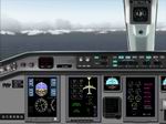
FS2004
Embraer Erj 170 Panel
(Category: FS2004 > Panels)
4.17Mb (5568 downloads)
FS2004
Embraer Erj 170 Panel.
By Ken Mitchell. 4.3MB
Posted Jun 23, 2008 14:26 by archive
FS2004
Cessna Skyhawk 172SP IFR Panel Avionics Upgrade
(Category: FS2004 > Panels)
0.61Mb (2577 downloads)
FS2004
Cessna Skyhawk 172SP IFR Panel Avionics Upgrade
This modification upgrades the default 172 IFR Panel avionics
to a Garmin 430/530 setup with the Garmin STX330 Transponder.
This is my first panel that I have created. With this being
my first panel, i know it is not perfect. I do believe i have
created something reasonable though. Also included is a CD Radio
that allows you to relax on those long flights with up to 12
song of your choice. I hope the FS community enjoys this panel
upgrade. By Chase Barnett. 627K
Posted Jun 23, 2008 14:26 by archive
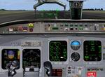
|FS2004
Metroliner III Panel
(Category: FS2004 > Panels)
7.40Mb (2849 downloads)
|FS2004
Metroliner III Panel .
A complete rebuild of my previous panel. Reworked bitmap to
give better forward vision and better scaled window, more realistic
colours and position of gauges. Gauges more readable and appropriate
to this aircraft. Addition of GPS and full FS2004 of Eric Marcianos
AI traffic radar. Other gauges include cargo door open and quick
refuel button. Steve Southey. 7.6MB
Posted Jun 23, 2008 14:26 by archive