


All Files > Page 4734
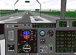
Hercules
C-130J
(Category: FS98 > Panels)
0.75Mb (882 downloads)
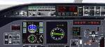
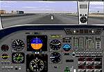
Hercules
C-130J FS98 Panel-C-130J panel v/4 by David Giles. Everything
v3.0 had plus: New 3D HUD* ADI by Chuck Dome! Adds HUD flight
director (ILS) and HUD now a separate display. Modifications
to all panel displays. Modified color weather RADAR. Many new
added gauges. Based on photos of actual panel. *Includes 2 HUD
options for 3D and non-3D video cards. Version 3.0 had over
2,200 downloads at flightsim.com alone. Tested in all modes
and 3D.(C 130) File size 789597
Posted Jun 23, 2008 14:21 by archive
Boeing
B17 Flying Fortress
(Category: FS98 > Panels)
1.21Mb (911 downloads)
Boeing
B17 Flying Fortress FS98 panel for the Boeing B-17G Flying
Fortress. By Dave Haskell photoreal with IFR capability File
size 1270773
Posted Jun 23, 2008 14:21 by archive
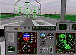
Bomardier
Global Express
(Category: FS98 > Panels)
0.52Mb (474 downloads)
Bomardier
Global Express Regional/Corp Jet-Bombardier Global Express.
FS98 Panel. Highly accurate panel that features: HSI ARC and
ROSE, Stall and Overspeed warning lights, Radio Altimeter, No
Smoking and Fasten seatbelt switches, Moving Map mode, and Panel
Switches to operate the MFDs. All instruments are lighted at
night. Designed in 800x600 mode, tested in all modes and 3Dfx.
Makes a nice panel for any Bombardier/Canadair RJ. By Paul Schwerdtfeger.File
size 548834
Posted Jun 23, 2008 14:21 by archive
Learjet
PhotorealFS98 Lear Jet 45 Photoreal
(Category: FS98 > Panels)
0.68Mb (642 downloads)
Learjet
PhotorealFS98 Lear Jet 45 Photoreal Panel V2.0 Includes
Control Surfaces, Trim Indicator, and a new PFD gauge, with
accurately colored displays. Also features a realistic autopilot,
realisticly colored radio stack, switchable MFD, and all controls
on main panel. By Ian Grant File size 717963
Posted Jun 23, 2008 14:21 by archive
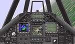
Lockeed
F-117 Stealth Flighter
(Category: FS98 > Panels)
0.65Mb (789 downloads)
Lockeed
F-117 Stealth Flighter Night Hawk 'Stealth Fighter' By Chris
Evans File size 682111
Posted Jun 23, 2008 14:21 by archive
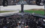
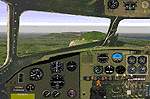
Douglas
DC3 Photoreal panel
(Category: FS98 > Panels)
0.86Mb (643 downloads)
Douglas
DC3 Photoreal panel FS98 Douglas DC-3 Photorealistic Panel
This is the panel of a Douglas DC 3 Built in 1939 and still
in use at Air BVI, Virgin Iland, Caribic By Thomas Ferber
File size 903254
Posted Jun 23, 2008 14:21 by archive
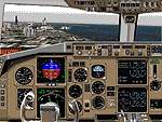
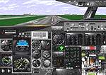
Boeing
767/757
(Category: FS98 > Panels)
(1644 downloads)
Boeing
767/757 767pgpnl.zip
Panel v1 for FS98, by Paul Golding Re-work of a Eric Ernsts
panel, now includes switchable HSI/ARC mode and removable
yoke, more realistic engine gauge colours, fuel switches,
landing gear wind noise, working autobrake, basic GPS and
more.File size 836758
Posted Jun 23, 2008 14:21 by archive
Cessna
Citation
(Category: FS98 > Panels)
(350 downloads)
Cessna
Citation FS98 Cessna Citation Panel David DurstFile Size
1004005
Posted Jun 23, 2008 14:21 by archive
Generic
4 Engine Jet
(Category: FS98 > Panels)
(745 downloads)
Generic
4 Engine Jet FS98 Generic 4 engines Jet Panel 4J-70.zip.
Semi-Photorealistic generic panel for late 1960-late 1970, 4
engine jet heavies B747-200, Antonov 225, Antonov 124, Russian
heavies, VC10, DC-8 etc.. Works with 3DFx/Monster3D.By Chris
Alevritis.Era late 60's & 70's File Size 1624021
Posted Jun 23, 2008 14:21 by archive
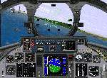
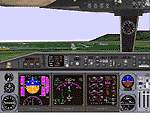
F14
Tomcat
(Category: FS98 > Panels)
(825 downloads)
F14
Tomcat FS98 PANEL - F-14d Tomcat Fighter. A FS98 panel for
the USN F-14d Tomcat Fighter. Based on F-14a & F-14d cockpit
photos. Designed in 800x600 mode and tested on a Monster 3D
II. Features include Working HUD, and MFD, custom engine and
fuel gauges, and a mouse clickable panel switch to operate the
MFD. By Chuck Dome & Paul SchwerdtfegerFile Size 661862
Posted Jun 23, 2008 14:21 by archive