


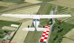
22.91Mb (1553 downloads)
FSX Valdera Airfield Scenery, Italy.
A complete scenery of Valdera Airfield,
home of the Aeroclub di Pisa "Federico Citi".
Includes photoreal of near towns and
some visual references. By Giuseppe Alonci.
Posted Aug 7, 2013 05:20 by Giuseppe Alonci
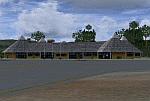
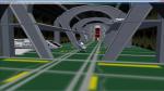
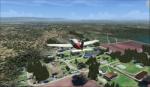
76.58Mb (879 downloads)
Located to south of Venezuela, to few kilometers from the border with Brazil.
The airport design, reflects the Pemon indigenous culture.
With photo-terrain scenery from satellite imagery of Google Earth.
Not compatible with versions prior to FSX.
This scenery requires SP1, SP2, or the Acceleration
expansion pack in order to be displayed correctly.
Also includes a friendly Auto-Install.
Posted Aug 3, 2013 08:10 by David Maldonado
11.75Mb (2382 downloads)
Updated scenery Chile. More than 70 airports and airfields improved or added.
This version replaces all previous versions of files. Made by Juan Lucero,
Posted Aug 1, 2013 17:33 by Juan Lucero
3.99Mb (277 downloads)
Graf Ignatievo AFB does not exist in FSX and also the on the some navcharts. Note that the real NAVAIDS frequencies could be different from those presented in the scenery. Read the notifications enclosed.
Posted Aug 1, 2013 13:12 by Sergey Stoyanov

10.85Mb (1315 downloads)
TOS and 2009 movie versionS of the USS Enterprise based at San Francisco, close to the Golden Gate. Bay areas and DiskS are landable. High resoultion graphics, night textures and animated engines . Author: RicardoPJr
Posted Jul 30, 2013 09:35 by Ricardo Peixoto Jr
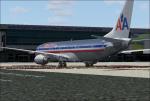
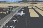
120.50Mb (1776 downloads)
MRLB Aeropuerto Internacional Daniel Oduber Quiros - Liberia, Costa Rica
FSX - FS2004
Posted Jul 30, 2013 09:19 by Luis Jimenez Trejos
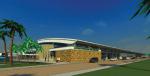
47.13Mb (1155 downloads)
Half Moon Bay Airport Photoreal. Half Moon Bay Airport (IATA: HAF, ICAO: KHAF, FAA LID: HAF) is a county-owned public use airport in San Mateo County, California (CA), USA. It is located five nautical miles (9 km) northwest of the central business district of Half Moon Bay. By Fernando Angel Gonzalez.
Posted Jul 29, 2013 11:28 by uploader
24.88Mb (625 downloads)
Monterey Bay Academy Photoreal. Monterey Bay Academy Airport (FAA LID: CA66) is located near the city of Watsonville in Santa Cruz County, California (CA), USA. This private use airport is owned by the Seventh-day Adventist Church and located on the campus of the Monterey Bay Academy, site of the former Camp McQuaide. By Fernando Angel Gonzalez.
Posted Jul 29, 2013 11:17 by uploader
0.07Mb (317 downloads)
Kasane Airport, Botswana, southern Africa. Elevation fix, and added few new buildings... Because of its location near Chobe National Park, the airport is mainly used for tourism.
Posted Jul 23, 2013 15:01 by Rilex037
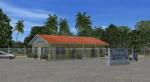
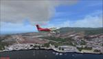
0.72Mb (765 downloads)
Arthur's Town Airport (MYCA) - The Bahamas.
One of three airports on Cat Island, named after the pirate Arthur Catt and home to Bahamian rake and scrape music. Academy Award winning actor Sidney Poitier grew up just outside Arthur's Town. The scenery includes custom scenery objects, placement of library objects and landclass changes. Scenery is based on photos taken locally, and it is optimized for use with UTX-TAC. By: Art Poole
Posted Jul 23, 2013 06:20 by uploader