


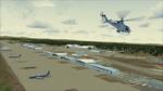
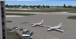
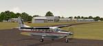
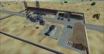
47.47Mb (3613 downloads)
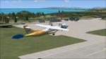
Fairchild AFB. Home to the KC-135 Stratotanker in high res photoreal coverage.
All buildings/Hangars custom made using Google Earth for reference.
Posted Jun 7, 2013 18:48 by Chuck79
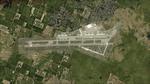
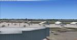
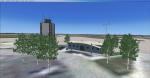
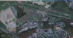
32.65Mb (2400 downloads)
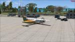
FSX SP2 LFPA Persan Beaumont scenery. Persan Beaumont is an historic airfield dating back to pre WW2 times when it had a 5000ft runway. Now used for general aviation. This is high detail scenery and a great place to fly light aircraft in FSX.
v 1.0 by Benoit Gaurant and Dan Guimbert
Persan Beaumont airfield is located in
the north suburbs of Paris in France.
June 2013
Posted Jun 6, 2013 09:50 by admin
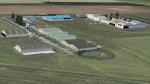
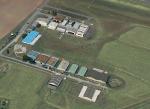
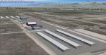
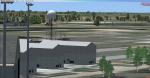
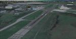
16.96Mb (877 downloads)
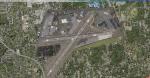
Martin State is located just north of Baltimore city. Home to the Maryland Air National Guard and Maryland State police, Baltimore County and City helicopters, and many general aviation aircraft. This scenery includes Photo Realistic images, Custom Objects and Default objects. Created by Tom Neubauer
Posted May 28, 2013 22:26 by Tom Neubauer
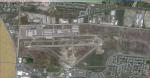
15.71Mb (981 downloads)
Located south of Salt lake city South west of the city, a gorgeous place to start a flight over the lake. Made with custom objects, default objects and photo-realistic ground textures. Created by Tom Neubauer
Posted May 28, 2013 21:33 by Tom Neubauer
2.11Mb (1120 downloads)
Virac Airport is the only airport serving the island province of Catanduanes in the Philippines. It is located in the capital, Virac. The airport is classified as a Class 2 principal (minor domestic) airport by the Civil Aviation Authority of the Philippines, a body of the Department of Transportation and Communications that is responsible for the operations of not only this airport but also of all other airports in the Philippines except the major international airports. This Scenery was made using Airport Design Editor. And the buildings came from FSX that is said to be default. This is my first Scenery, tested in FSX SP1 and SP2 but not tested in Deluxe and DX10. In case of errors or bugs, please contact me immediately.
Posted May 27, 2013 23:04 by Aeron M. Tumanut
9.80Mb (848 downloads)
Located on Long Island, NY, this airport is where a lot of Long Islanders achieved their flight training. The airport comes with photo realistic scenery, as well as custom objects and default objects. Created by Tom Neubauer
Posted May 24, 2013 23:57 by Tom Neubauer
1.87Mb (499 downloads)
FSX Bradford Regional Airport
in north western Pennsylvania.
A complete remake of BFD (ICAO=KBFD).
Compatible with default FSX Scenery
and MegaScenery Earth 2.0 PA
By Thomas M. Lewis
Posted May 24, 2013 23:51 by uploader
29.00Mb (483 downloads)
Welcome to Millington Regional Jetport. A larger airport from the typical airports I do, but still a good location. Lots of sights to see, and fairly flat ground. Located in Tennessee. Package includes Custom objects, default objects, and photo realistic ground textures.
Posted May 23, 2013 02:53 by Tom Neubauer
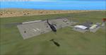
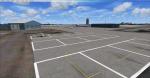
0.00Mb (515 downloads)
This is a fictional USAF base near Edwards AFB. It includes a little FBO with parking cars and a nice parking field with 2 black hawks and other objects. It also includes a helipad and a control tower. ICAO: 28CL- Borax
Posted May 22, 2013 09:47 by EL3cTR0o
22.16Mb (831 downloads)
This was a user requested scenery. Located in South western Virginia, this Appalachian airport is great to fly out of into the mountains. Includes photo-realistic scenery, custom objects and FSX Default objects. Created by Tom Neubauer
Posted May 21, 2013 12:17 by Tom Neubauer