


66.13Mb (1807 downloads)
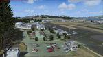
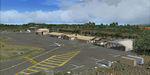
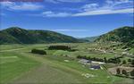
KFHR Friday Harbor Airport Photorealistic.
Friday Harbor Airport is a GA airport located just southwest of Friday Harbor on San Juan Island, Washington.
This Scenery consists of the FSX default airport of Friday Harbor, set on photorealistic terrain. Although the scenery has been compiled with night masks, night terrain has been excluded to reduce the file size. It has been designed for Megasceneryearth photoreailtic scenery of the San Juan Islands but will also work with the default terrain. Seasonal variations are not included. The main scenery file has been subdivided into several smaller files, which can be switched off according to user preference. Full night textures are included with wash lighting in the terminal and carpark areas. All buildings have been custom modelled using real photographs, and include open hangers with interiors.
Next to the fuel station you will find Ernie's Cafe, much loved by resident and visiting pilots. Close to the airport you will find US style houses modelled on real photographs from the San Juan island. Surfaced airport taxiways and aprons have been kept to a minimum to allow the photoreal textures to show through. The scenery also includes sound effects and high definition people, these can be switched off if they place too much strain on your system. Thanks to George Keogh for creating this.
Posted Mar 13, 2016 10:51 by uploader
12.64Mb (918 downloads)
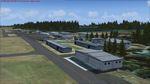
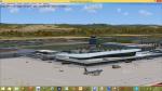
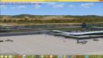
LUKK Chisinau X, the first commercial airport scenery in Moldova, features a highly detailed representation of LUKK Chisinau International Airport. This product is compatible with FSX and FSX Steam.
It's a fully functional DEMO version of the commercial payware product. It features same airport layout as in the full version but with limited 3D objects and low resolution textures. Using this free demo ensures no problems with online (VATSIM, IVAO, multiplayer etc.) flying in case some users use the payware scenery and some don't.
Chisinau International Airport is Moldova's main international airport, located 13 km (8.1 mi) southeast of the centre of Chisinau. Currently airport features one 3580m concrete, ILS-equipped runway, able to accomodate airliners of any type, including B747. Nowadays 19 airlines operate flights to 33 destinations and the most popular destination is Moscow.
It's equipped with an automatic installer, which means that the scenery will be automatically added to the Flight Simulator Scenery Library.
Please uninstall all previous versions of this airport you may have installed before. Please make also sure that no duplicated AFCAD files are installed!
Enjoy your virtual flying with Drzewiecki Design!
Posted Mar 12, 2016 14:43 by Drzewiecki Design
82.53Mb (2179 downloads)
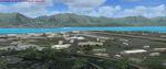
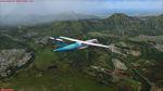
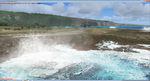
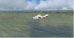
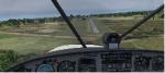
Hawaiian Airports Part 3
This scenery features the airports at Princeville, Port Allen, Waimea and Upolu. HI01-Princeville and PAK-Port Allen are located on the island of Kauai, the film location made famous by Stephen Spielberg's blockbuster, Jurrasic Park. PHMU-Waimea and PHUP-Upolu are located in the North West of Hawaii, also known as the Big Island. All runways, aprons, taxiways and buildings have been repositioned to their correct locations, and the scenery has been recreated based on photos of the real airports. The scenery features many animated objects including people, aircraft, animals, waves, cars, trucks and many more. Full night textures with light maps are included.
All the scenery files have been sub-divided so they can be switched on or off according to user preference and hardware configuration. It has been designed for, and tested in DX9 and FSXA only. The airports include sloped flattens so they can also be used with high density mesh.
This file also includes updates for Hawaiian Airports Part 2. George Keogh
Posted Mar 12, 2016 06:23 by uploader
152.42Mb (2425 downloads)
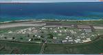
Hawaiian Airports Part 2
This scenery features the airports at PHJR John Rodgers Field, PHBK Barking Sands, NPS Ford Island and PHNG Kaneohe Bay. All runways, aprons, taxiways and buildings have been repositioned to their correct locations, and include custom textures based on photographs of the real airports. The scenery features many animated objects including people, aircraft, animals, waves, cars, trucks and many more. Full night textures with light maps are included.
All the scenery files have been sub-divided so they can be switched on or off according to user preference. It has been designed for, and tested in DX9 and FSXA only. The airports include sloped flattens so they can also be used with high density mesh. These airports have long runways and can easily cater for the 'heavies', PHJR now acts as a backup to the main airort at PHNL Honolulu. Runway 04 at PHNG is a real challenge, and requires a 90 degree turn under the mountains.
Posted Mar 12, 2016 05:49 by uploader
232.43Mb (2559 downloads)
Hawaiian Airports Part 1
This scenery features accurate recreations of the airports at PHMK Molokai, PHNY Lanai City, PHHN Hana, PHLU Kalaupapa, and JHM Mauai West. All runways, aprons, taxiways and buildings have been repositioned to their correct locations, and include custom textures based on real photographs. The new hanger has been added to Hana and also the new fire stations at Lanai and Molokai. The scenery features effects, sound, many animated objects including people, flags, animals, waves, cars, trucks and many more. Full night textures with light maps are included.
The scenery also includes representative, and real interisland traffic schedules, and the HAL ATR is sporting the new OHana livery.
All the scenery files have been sub-divided so they can be switched on or off according to user preference. It has been designed for, and tested in DX9 and FSXA only. George Keogh
Posted Mar 12, 2016 04:45 by uploader
0.00Mb (326 downloads)
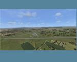
Upfield farm (X2FU) was (?) a small farm strip between Newport & Chepstow in the UK. The owner got into trouble after adding a paved runway adjacent to an existing grass runway without getting the required planning permissions to do so. Retrospective permission was not granted, and the paved runway had to be removed.
To install simply unzip the zip to the FSX addOnScenery folder. The zip also contains a fix for a fault in the default terrain between Uskmouth and the SSC.
Posted Mar 9, 2016 14:19 by zihamesh
1.42Mb (405 downloads)
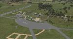
Mangalore Airport is located in central Victoria, Australia and provides pilot training services and facilities for student pilots.
This airport has been modeled from photographs freely available off the internet. This package has two versions. One is for anyone who has the orbxAU/Blue package installed and the other is for generic fsx landscape. The two options are provided as the blending of the airport into the surrounding scenery is different for each. I have modeled the main terminal building and a couple of buildings close to it and the control tower so as to look
something like the actual ones but I have used generic textures in addition to some of my own.
All the other buildings are generic ones and chosen for their size and architectural resemblance (albeit rather vague because of the generic library lack of choice) to the actual ones. I have included two hangars of my own but these are not exactly like those at the actual airport but are similar in size and shape. This means that the overall layout reflects the actual airport but the finer detail does not. In any event its an improvement on what came with the default version.
Posted Mar 7, 2016 19:01 by Robert Budd
2.36Mb (251 downloads)
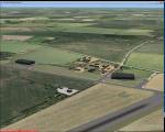
RAF Spanhoe (also known as Harringworth or Wakerley) (ICAO X3SE) is a former World War II airfield in Northamptonshire, England. The airfield is located approximately 4 miles (6.4 km) east of Uppingham; about 80 miles (130 km) north-northwest of London
Opened in 1943, it was used by both the Royal Air Force and United States Army Air Forces. During the war it was used primarily as a transport airfield,
it was closed in late 1945 after the WWII.
Today, much of the airfield has been returned to agriculture, however; the remains of some of the runways can be seen from the air and a part of the old peri track is used by various privately owned light aircraft which are housed at the old airfield.
Source: Wikipedia
Posted Mar 7, 2016 09:59 by Terry Boissel
0.09Mb (1003 downloads)
A collection of airfields for VFR flying in Austria, which are not included
in the FSX/P3D:
LOSM Mauterndorf,
LOKH Hirt,
LOKW Wolfsberg,
LOGI Trieben,
LOIK Langkampfen,
LOGL Lanzen-Turnau,
LOAS Spitzerberg,
LOLG St. Georgen,
LOKF Feldkirchen,
LOLE Eferding,
LOLF Freistadt.
The airfields are placed according Google-Earth coordinates using standard
objects. May be it is not perfect but better than nothing.
Juergen Wolf
Posted Mar 7, 2016 02:53 by Juergen Wolf
454.79Mb (2754 downloads)
Graz Airport, known as Flughafen Graz-Thalerhof in Austria,
is a minor international airport in Graz, the second-largest city in Austria.
It is located in the south of the alps the airport serves
flights to European leisure and some metropolitan destinations.
in this version you have new animated people,
no flakering,
new animated vehicle,
new Taxiway-light, seasonal textures,
Hospital UKH-Graz and LKH-Graz.
new buildung arround the Airport.
This will be my last freeware-version of LOWG.
the version is tested in FSX and P3D
thank you and have fun
Manfred Marbler
manfred.marbler@aon.at
Posted Mar 3, 2016 11:18 by manfred marbler