


All Time Popular > Page 3897
FS2002
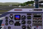
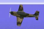
De Havilland DH82A Tiger Moth Panel.
(Category: FS2002 > Panels)
4.15Mb (576 downloads)
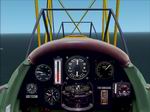
FS2002
De Havilland DH82A Tiger Moth Panel.
This is an add on for the FS2002 De Havilland Tiger Moth Collection
by John Woodside. It requires the FS2000 Spitfire, Hurricane
and P38f Lighting gauges. Many thanks to Claude Malet for supplying
the panel photo. By Eliezer Rice. 4.2MB
Posted Jun 23, 2008 14:32 by archive
FS2002
Scenery for South Africa. Wonderboom Airport (FAWB), Pretoria,
South Africa.
(Category: FS2002 > Scenery)
5.36Mb (576 downloads)
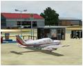
FS2002
Scenery for South Africa. Wonderboom Airport (FAWB), Pretoria,
South Africa.
A highly detailed airport containing photorealistic ground textures,
hangars and buildings. Wonderboom is a General Aviation Airport
located north of Pretoria, South Africa. It is a fairly busy
airport being used by various flying schools. By Henning van
Rensburg and Johan van Wyk, Aeroworx. 5.5MB
Posted Jun 23, 2008 14:31 by archive
FS2004
Itumbiara City (Brazil).
(Category: FS2004 > Scenery)
1.33Mb (576 downloads)
FS2004
Itumbiara City (Brazil).
This is my 1st attempt at visual scenery inspired by good job
of Leandro Maldonado. I hope that you enjoy flying past this
model and for those that have seen it, i hope it evokes fond
memorys of Itumbiara and its many sights. Requires original
Itumbriara scenery
here. Manuel Castelo Branco. 1.3MB
Posted Jun 23, 2008 14:25 by archive
Bell
412 / Griffon. For FS 2000 only..
(Category: FS2000 > Helicopters)
1.39Mb (576 downloads)
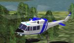
Bell
412 / Griffon. For FS 2000 only.. Aa simple repaint of Brian
Whiteleggs Bell 412, with new panel and interior sound. Designed
by Brian Whitelegg using FSDS and Aircraft Animator. Repaint
by Mike Busby. 1.4MB
Posted Jun 23, 2008 14:37 by archive
FS2000
Extra 400,
(Category: FS2000 > Props)
2.23Mb (576 downloads)
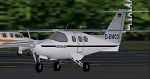
FS2000
Extra 400, A high wing single that cruises at 250 knots.
AFX: Jerry Arzdorf FDE, Paint and Panel: Michael Verlin NOTE:
For FS2000 Professional ONLY. 2.3MB
Posted Aug 24, 2009 06:45 by archive

FS2002
Zip Air Boeing 737-200's
(Category: FS2002 > Civil Jets)
1.07Mb (576 downloads)
FS2002
Zip Air Boeing 737-200's
Four 737-200's from AI Aardvark designed especially for AI traffic.
Features 6 LOD models and moving parts. Very detailed, includes
animated gear, flaps & spoilers, thrust reversers, antennas,
flap canoes and simulated gear bays and specular highlights.
Extremely frame rate friendly. Includes optional reflective
model. Model by David Rawlins Paint by Boback Shahsafdari FDE
by David Carter. 1.1MB
Posted Jun 23, 2008 14:33 by archive
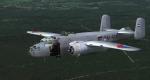
MAAM B-25 Netherlands Air Force M-464
(Category: FS2004 > Payware)
7.92Mb (576 downloads)
This folder contains a repaint for the donationware MAAM-Sim B-25J 'briefing time', in the colors of an aircraft of the Dutch East Indies Air Force (ML-KNIL). M-464 served with the ML-KNil between 1945 and 1950, after which is was turned over to the Indonesian Air Force. It flew last in 1965, and came to the Netherlands in 1971. At present it is on display in the Dutch Air Force Museum in Soesterberg in the colors of this repaint. Repaint by Jan Kees Blom.
Posted Feb 23, 2010 09:33 by Jan Kees Blom
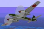
Mitsubishi KI-83 Upgrade
(Category: CFS1 > Aircraft)
0.18Mb (576 downloads)
CFS Mitsubishi KI-83 Upgrade.
New version with animated flaps and landing gear.
Original KI-83 / FS98 aircraft, converted to CFS1 with new panel, damage profile and repainted textures.
The Mitsubishi KI-83 was a Japanese Army Experimental Long Range Fighter.
Original design: 'flyman' Yusaku Honma.
Panel: I used the panel of P38 Lightning (P51D 2-props)
modificated by Jørn Kudla /2000(included).
Repainted textures, moving parts, damage profile, and air file: © Edmundo Abad, Feb 2010.
Posted Feb 12, 2010 06:26 by Edmundo Abad
Beechcraft T-34 FACH
(Category: CFS1 > Modern Aircraft)
1.30Mb (576 downloads)
The Chilean Air force operated the Beechcraft T-34 between the years 60s-80s, mainly in basic training and with hardpoints for light attack training. Homebased at Escuela de Aviación Capitán Avalos, El Bosque airbase, Santiago.
Currently, on this task has been replaced by the ENAER T-35 Pillan.
Also, the Chilean Navy operated the Mentor, as B-45 denomination, before the arrival of his currently trainer Pilatus Pc-7.
Posted Dec 27, 2009 14:21 by Edmundo Abad
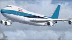
FSX Boeing 747-258C EL AL 4X-AXF
(Category: FSX > Civil Jets)
238.09Mb (575 downloads)
She had her first flight on June 7, 1978 from Everett and was then delivered to the Israeli EL AL Airline.
Normally configured for 470 seats, she could also function as a pure freighter as she was equipped with a bow cargo door!
What makes she so special to this day, however, is a flight that took place during Operation Solomon between May 23rd and 25th 1991.
During this Operation, over 14.000 Ethiopian Jews were flown out of Addis Ababa on over 30 Israeli Air Force and EL AL transport aircraft, including three 747s!
On one of these flights, a total of 1,088 passengers were flown to Tel Aviv with this 747, a world record that remains unbroken to this day!
What was also unusual was that this flight was flown without an autopilot, as the automatic trim did not work properly before departure from Addis Ababa
and last but not least, a child was born during the flight, breaking the record twice in one flight!
After 31 Years in Service for EL AL and also for Cargo Air Lines, she was scrapped in July of 2009.
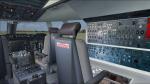
Many thanks to Christian Koegler from the RFP team for the permission to publish this mod with their 747-200 model with VC,
Barnaby Britton for his permission to use his great "RA001, the first jumbo jet" Flight engineer panel photo as 2D & VC FE panel background,
Marco Ravanello & Gianfranco Corrias for the great CIVA INS,
Jacob Larsen and Anthony Eades for the very useful V speeds callout gauge,
Charles Owens for his innovative icing mod,
Philippe Wallaert for his "2D view panning" mod,
Mike Maarse for his "it will knock your socks off" Pratt & Whitney soundset,
Douglas S. Dawson for his great programs that allows us to save and reload Vars,to play Sounds files and of course for his Batterycharger
and to Dietmar Loleit, who passed away in 2020, for his great working TCAS!
Tested only in FSX & Acceleration!
Posted Oct 13, 2023 14:41 by Andiroto