


All Time Popular > Page 4056
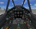
FSX/P3Dv3,v4,v5 SF_corncob_Reno_Racers
(Category: FSX > Vintage)
19.23Mb (517 downloads)
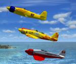
FSX/P3Dv3,v4,v5 SF_corncob_Reno_Racers
Dreadnought and Furias are modified T.20 Hawker Seafury powered by the worlds largest production built piston engine, the Pratt & Whitney R-4360-63B putting out around 4000HP. This engine was nicknamed "corncob" with the spiraled 28cylinder setup. Dreadnought mdl, textures and aircraft.cfg have been modified to the Furias specifications.
Upgraded Native FSX/P3D mdls by A.F.Scrub
Posted Mar 22, 2023 13:18 by A.F.Scrub

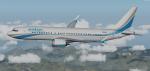
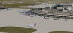
FSX/P3D Boeing 737-600 Tunisair package v2
(Category: FSX > Civil Jets)
77.27Mb (517 downloads)
FSX/P3D Boeing 737-600 Tunisair package v2.
Tunisia's flag carrier airline is based at Tunis-Carthage International Airport and currently have 7 Boeing 737-600 flying to destinations around North Africa, Europe and the Middle East.
I am revising many of my 1st repaints to fix errors and improve the package. Credit goes to TDS for the great model and paint kit.
Package includes revised Boeing 737-800 VC by Alejandro Rojas Lucena/FSND/Ken Wiggington upgraded Boeing 737-800 VC model. Autobrake switch. Opening pilots window. Cabin Lights switch. Realistic FMC. Ground Proximity Warning System (GPWS). Includes added MFD and PFD panels. Exits, wheel levels, jetways and views corrected for FSX/P3d.
See VC docs to get the best out of the VC and FMC.
Textured and texted in P3D 5.3 by Chris Evans. Should also work in earlier P3D versions as well as FSX.
Posted Feb 28, 2023 04:22 by chris evans
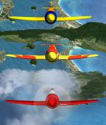
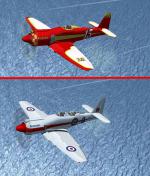
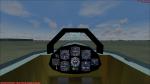
FSX/P3D v3 v4 v5 Hawker Sea Fury Reno Racers
(Category: FSX > Vintage)
21.67Mb (517 downloads)
FSX/P3Dv3.v4.v5 Hawker Sea Fury Reno Racers
The Sea Fury was retired by the majority of its military operators in the late 1950s in favour of jet-propelled aircraft, a considerable number of aircraft saw subsequent use in the civil sector, and several remain airworthy in the 21st century as heritage and racing aircraft. Many were re engined with an american engine, a four bladed prop, modified canopy and bigger spinner.
Upgraded Native FSX/P3D mdls by A.F.Scrub
Posted Feb 22, 2023 09:39 by A.F.Scrub
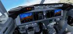
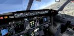
FSX/P3D Boeing 737 Max 8 Enter Air package with Max themed VC
(Category: FSX > Civil Jets)
84.42Mb (517 downloads)
FSX/P3D Boeing 737 Max 8 Enter Air package with new Max VC. Enter Air is a Polish charter airline based at Warsaw Chopin Airport and operates flights to holiday destinations around Europe. Currently Enter Air has 2 Boeing 737 Max 8 with another 4 on order.
The high spec Boeing 737-Max 8 from TDS. The VC is the Microsoft/Alejandro Rojas Lucena/FSND base modified by Speedbird77 to resemble a Max cockpit, including gauges by G. Munro.
There are custom CFM eco sounds included for that extra realism. Use - Instrument panel - Util for ground vehicles, doors stairs, fuel truck, buses. New Utility allows Bus, fuel, doors and more. (Go to Views - Instrument panel - Utility). VC added and edited to allow correct VC views, correct jetways and wheel levels. Credits go to TDS quality native FSX Boeing Max8 model. I added PDF B737 checklist.
Textured, packaged and prepared for FSX & P3D up to v5 by Chris Evans.
Posted Aug 4, 2021 11:57 by chris evans
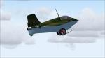
FS2004 only Messerschmitt Me-163B Komet
(Category: FS2004 > Vintage)
17.76Mb (517 downloads)
FS2004 only Messerschmitt Me-163B Komet with independent working skid and trolley, so you can start on the trolley and land on the skid. Nice 2D and rudimentary VC, both with working gauges (all included) and extra panels, also smoke- and guneffects for fun. Updated soundfile with glidersounds. All credits go to Ignacio Alfredo Mendive, the original designer. Enjoy!
Posted Jul 24, 2018 16:03 by Erik Hertzberger
KDFW - Dallas-Ft Worth Intl Airport, Texas
(Category: Prepar3d > Scenery)
5.00Mb (517 downloads)
KDFW - Dallas-Ft Worth Intl Airport, Texas, USA (ILS fix for runway 18R/36L).
This is Ray Smith's FSX file. Ray has given me permission to modify his file for P3Dv4. This is a very accurate version for KDFW to reflect today's situation with two optional files: one version with the Crosswind runways operating where all 7 runways will be used for takeoff/landing and one version as the default airport runway operation. Assigned parking at all terminals now as per their website, extra parking including a gate for the A380 at Terminal D. Start location added to the helipad. Magnetic Variation corrected to 4.0 degrees East. All ILS approaches, taxiways and taxi signs updated and corrected to the latest charts. Extra fuel trucks, support vehicle roads rebuilt and many other scenery improvements and objects added. By Robert Catherall
Posted Jul 15, 2018 06:43 by uploader
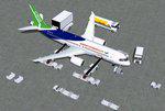
FSX House Colors Comac C919 V5L
(Category: FSX > Civil Jets)
5.28Mb (517 downloads)
FSX House Colors Comac C919 V5L. The Comac C919 is a Chinese 2 engine airliner expected to come into commercial use in 2021. Night lighting effects have been upgraded.
Including CamSim's own static displays and Animated Ground Servicing (AGS). 2d panel but no VC.
Model design and paint by Camil Valiquette.
Posted Apr 12, 2018 04:25 by Camil Valiquette
Ottawa 2016
(Category: Prepar3d > Scenery)
27.46Mb (517 downloads)
Prepar3d Scenery -
Ottawa 2016.
Extensive scenery for the city of
Ottawa, capital of Canada. Contains
more than 200 custom and default objects,
including landmarks like Parliament Hill,
many buildings in the downtown core and
the Byward Market, shopping areas like
Bayshore and Carlingwood Mall, sports
facilities like Lansdowne Park and the
Canadian Tire Centre, and many more.
Also adds many roads, some with ground
traffic, and extensive areas of
landclass.
Several Easter Eggs are visible to
pilots willing to search.
By Andy Johnston.
Posted Jun 12, 2016 00:44 by uploader
Heli Slingload Fun
(Category: FSX > Misc)
0.54Mb (517 downloads)
Just a small file so that you can use AI Carriers to add objects from the FSX Accel missions for hoist and sling load operations. You will need FSX Acceleration and AI Carriers2 installed for this to work.
Posted Jan 13, 2016 09:41 by Dave T
FS2004 USA Landclass AddOn - Vegetation Part I V2
(Category: FS2004 > Scenery)
4.03Mb (517 downloads)
Landclass Improvements for the USA, specialy the western Part of the USA:
Colorado, Utah, Yellow Stone, little Part of Idaho, Montana and from LA to Seattle,
Bristish Columbia and also some Testscenery's for the eastern Part of the USA (Arkansas KHOT and around KLWB ). Udate: Simplification of Scenery and batch (Option) installation files.
Posted Mar 6, 2015 04:21 by Markus Balz emineo@t-online.de