


All Time Popular > Page 4232
FS2002
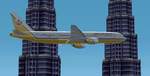
Royal Brunei Airlines Boeing 777-300 Ver. 2.0
(Category: FS2002 > Civil Jets)
0.40Mb (459 downloads)
FS2002
Royal Brunei Airlines Boeing 777-300 Ver. 2.0 FS2002 Royal
Brunei Airlines Boeing 777-300 repaint. Texture includes reflective
effect and improved color. Repaint by A. I. Hj. Jumat. 410K
Posted Jun 23, 2008 14:34 by archive
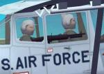
M60 for O-1F Bird Dog
(Category: CFS2 > Aircraft)
0.09Mb (459 downloads)
These files will visually add an M60 machine gun to the observer's position of the O-1F Bird Dog. Now you can give guy on the ground some fire support until the Sandies arrive on scene.
The idea came from BUB, Bob McGee. I did the M60_MG.BGL and associated files.
To install simply place the files from the download folders/subfolders into the corresponding folders/sunfolders of your CFS2 Main directory.
This is freeware, but must not be uploaded to another site or modified without permission. Enjoy.
Posted Feb 11, 2010 13:24 by Tom Sanford, Tango_Romeo
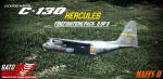

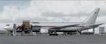
P3Dv4+ C-130 Firefighters Pack 2
(Category: Prepar3d > Military)
436.82Mb (458 downloads)
This is a continuation of Pack 1. This is a comprehensive large modification package for the stock P3D C-130s. This is a component based mod, meaning you will need files from your stock P3D C-130s to complete these successfully. The pack has 9 variations across 3 models. Those models represent the C-130H3, HC-130H, and C-130J-30. All of which have been equipped with the Aero Union palletized Modular Airborne Fire Fighting System (MAFFS) II in/to the aircraft. The unloaded system weighs 15,000lbs empty and with a full load of 3,000 US Gallons of fire retardant weights approximately 42,000lbs. The system is extremely flexible and can be rolled on/off and fully installed/uninstalled in 4 hours time without any airframe modifications. Reloading the aircraft with retardant takes as little as 12 minutes. Not only have the models been overhauled, but PBR has been added to them, as well as custom sounds for all models. As they all sound a bit differently due to engine and propeller differences. The pack includes aircraft from all current USAF MAFFS Units in Wyoming, Colorado, California, Nevada, and a single aircraft representing the the brief USFS internal tanker program. Models are only compatible with P3Dv4, 5, and 6. Textures will work on FSX models, but with user modification. Modifications and repaints by Nicholas Mitchell "Scorch00"
Posted Aug 28, 2023 01:34 by Nicholas Mitchell
P3D/FSX Are Ostersund Airport (ESNZ), Sweden
(Category: Prepar3d > Scenery)
57.89Mb (458 downloads)
Are Ostersund Airport (ESNZ), Sweden, previously known as Ostersund–Froson Airport (ESPC) This scenary was only tested on P3Dv4.5. Should work in other P3D and maybe FSX.
Posted Sep 29, 2022 01:40 by Eduardo Puelker
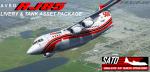
FSX/P3D QW RJ85 Firefighting Repaint & Tank Pack
(Category: Prepar3d > Payware)
396.76Mb (458 downloads)
This is a unique addon package for the payware Quality Wings RJ85 for either FSX or P3D. However, those with P3D will benefit more from this package. The QW Ultimate 146 Collection and Lorby's FireFighterX are required for the entirety of this pack to function. The package includes 12, 4K liveries for Australia, Canada, and US operators of the RJ85. Not only that, but we have put together a tank attachment to be used with Lorby's FireFighterX to complete the correct configuration of the firefighting RJs. The RJ85 like the other 146 platforms used in aerial firefighting are capable of carrying up to 3,000 US gallons or over 11,300L of fire retardant. The unique conformal style retardant tank used on the RJ have given it the "pregnant" 146 look that makes it stand out from the other 146 platforms in the industry. The tank is only compatible in P3D, due to FSX limitations. However, the liveries are compatible in FSX as well as P3D. The tank has been included with a blank texture as well to allow it to be attached/repainted to other versions of the 146/RJ that are not the QW product. However, this also does not guarantee a perfect fit, as the QW product was the base for the tank. But is theoretically possible, despite being untested on other versions. Tank was tested in P3Dv4 and textures tested in FSX and P3Dv4. Pack and repaints by Nicholas Mitchell, RJ85 Tank Model by Jeremy Ulloa.
Posted Mar 26, 2022 15:42 by Nicholas Mitchell
FSX/P3D Boeing 767-300F ABX Air package v2
(Category: FSX > Civil Jets)
69.00Mb (458 downloads)
FSX/P3D Boeing 767-300F ABX Air package v2. ABX Air is an American cargo airline with it's main hubs at Miami, Kentucky and Cincinnati. As of January 2020, ABX operate 8 Boeing 767-300 freighter aircraft with DHL being it's main customer.
Revised night textures, flight dynamics and vc textures.
The Skyspirit/Project Opensky FSX native Boeing 767-300 CF6-80C model and paintkit.
Advanced 737-800 VC added,
Alejandro Rojas Lucena/FSND revised Boeing 737-800 VC model. Added HUD. There are custom Boeing sounds included for that extra realism. Jetways also edited (Ctrl j). Exits, wheel levels and views corrected for FSX/P3d. Boeing 767 checklist included.
Added 767 sounds for more realism. Fixed viewpoints and jetways. Added wing views.
See VC docs to get the best out of the VC and FMC.
Textured, assembled and tested in P3D v5.3 by Chris Evans. Should also work in FSX and earlier P3D versions.
Posted Feb 20, 2022 10:49 by chris evans
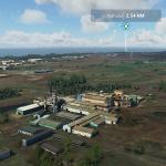
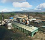
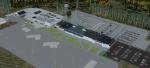
PHOG Kahului Maui Approach landmark - Puunene Sugar Mill scenery, Hawaii
(Category: MSFS > Scenery)
10.74Mb (458 downloads)
This scenery work compliments the approach into PHOG where Hawaii's last operating Sugar Mill is a prominent landmark 1.5 nm from the runway. There is visual approach named after it - "Smoke Stack" approach for Rwy 2. The Hawaiian Commercial & Sugar Company mill stopped operating in December 2016 ending its 130 year life and with that Hawaiis sugar industry. This scenery brings it back to life for P3D V3 and V4 (earlier version and FSX should be fine) complete with steam and smoke effects in "cane crushing" season.
As a Hawaiian Airline pilot stated - he had a lot of good time "crossing the mill" stabilized at 500ft on finals to PHOG Kahului, Maui.
Posted Sep 16, 2020 01:26 by uploader
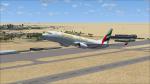
FSX Default Boeing 737-800 Emirates Textures
(Category: FSX > Civil Jets)
8.14Mb (458 downloads)
Emirates textures for the default FSX Boeing 737-800.
If you like this and my other liveries? Then please comment at Youtube with the hashtag #LiveryFSX YouTube Name: Planespotter Nordhessen
Posted Jun 9, 2020 03:13 by Planespotter Nordhessen-YT
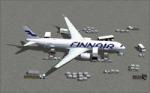
Finnair Airbus A350-900
(Category: FSX > Civil Jets)
11.42Mb (458 downloads)
FSX Finnair Airbus A350-900 AGS V6. Mainly the version 6 is for the new ground animations.
New animations and static display has been added from previous versions, including multiple animation effects to one object.
Aircraft wingspan / newest winglets have been upgraded, also featuring a new 2D panel.
Note: all CamSim aircraft models included exclusive Animated Ground Servicing (AGS) and static displays. 2d panel but no VC. Not compatible with P3D4.
Model design and paint by Camil Valiquette.
Posted Sep 6, 2018 05:20 by Camil Valiquette
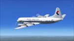

FS2004/FSX Lockheed L-188 Pacific Western Airlines
(Category: FSX > Props)
2.60Mb (458 downloads)
Textures for the L-188 in Pacific Western Airlines colors. The freeware L-188 by Libardo Guzman is needed for this repaint. PWA operated a total of 4 L-188s from 1971 to 1976. This aircraft is CF-PWG which flew for PWA from 1972 to 1976.
I have included DXT3 textures, which will enable the FS2004 users to fly this plane. Just copy the DXT3 textures in the enclosed folder, then paste them into the main L-188 folder, overwriting the files there.
Required files:
required file
Posted Jun 15, 2018 08:25 by Ted Giana