


All Time Popular > Page 4447
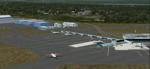
Stanfield Int. CYZH, Halifax, Nova Scotia
(Category: FSX > Scenery)
17.24Mb (386 downloads)
Stanfield Int. CYZH, Halifax, Nova Scotia, for FSX.
All new. Wherever possible buildings are modeled on photos. Rwy 6/24 changed to 5/23 and extended to 10,500'. Rwy 15/33 changed to 14/32. By Sidney Schwartz
Posted Nov 13, 2018 12:40 by Sidney Schwartz

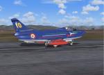
Boeing 767-300 United Airlines blue tulip livery and Star Alliance livery
(Category: FS2004 > Civil Jets)
25.05Mb (386 downloads)
2004 United Airlines Boeing 767-300 in 2004 blue tulip livery and Star Alliance livery Model by SkySpirit2010. Livery by Joe Shimmel.
Posted May 25, 2018 09:47 by chrisE

De Havilland DH 125 Maersk Air Textures
(Category: FSX > Civil Jets)
39.51Mb (386 downloads)
Maerst Air textures only for the De Havilland DH 125 by Rob Richardson.
(External site link)
Required
file (external site. Please report if broken)
Posted Mar 2, 2018 10:18 by bexel

Cathy Pacific Airbus A350-900
(Category: FS2004 > Civil Jets)
3.58Mb (386 downloads)
FS2004 Cathy Pacific Airbus A350-900 V5. This version 5, features more improved and detailed aircraft model, ( image comparison between v5 and v4 inside ), also modifications have been done on both, taxi lights and wing lights.
Taxi lights will add new night lighting on main landing gears and wheels and add bleu LED ground lighting effect for each gears.
Landing light will add logo lights on winglets, ( more info regarding proper functioning of the night effects in the Read Me FS2004 ).
Version 5, included CamSim's own static displays and Animated Ground Servicing (AGS).
Model design and paint by Camil Valiquette
Posted Sep 4, 2016 02:09 by Camil Valiquette
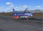
G91 Freece Tricolori Pony 10 Textures
(Category: FS2004 > Military)
2.08Mb (386 downloads)
This is a repaint(textures only) for Kazunori Ito's G91R1A available on this site. The aircraft is representative of the Freece Tricolori Pony 10 from 1963 to 1967. Original model by Kazunori Ito, repaint by Ron Wildman Gillam
Required files:
required file
Posted Dec 6, 2014 22:51 by Ron Wildman Gillam
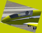
BEDE BD 5 Chrome Textures
(Category: FSX > Props)
0.94Mb (386 downloads)
Chrome textures for the BEDE BD5 Homebuilt kitplane.
Required files:
required file
Posted Sep 8, 2014 19:23 by VINCE
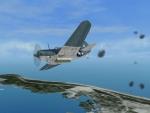
RS Wake 1945 Mission Pack
(Category: CFS3 > Missions & Campaigns)
0.01Mb (386 downloads)
This is a mission pack of 2 historical missions to fly the Helldiver in Rising Sun.
Posted Dec 30, 2012 09:43 by Led Zeppelin

ASTER GDEMv2 30m mesh for Arabian Peninsula Pt7b
(Category: FSX > Terrain Mesh)
57.85Mb (386 downloads)
There are Twenty parts of this mesh to download as separate files.
ASTER GDEM Version 2 is a 30 metre definition DEM, its better than the version 1 data that ERSDAC, of Japan and NASA originally released, but it does have its limitations.
GDEM has been obtained from a satellite that uses stereoscopic infrared scanning cameras, this brings with it problems in the resultant data.....where it sees the tops of trees, buildings etc, as the ground terrain.
If you look at the jpg image with the terrain type errors shown as a graph, you will see that the only 'safe' terrain to use this data with - in FSX - is scrubland, or desert terrain.
Its hopeless in defining the terrain in places like Europe - with all the artificial structures, (buildings) and different types of woodland, so any mesh I create from this data won't include areas like that....it will be more desert type terrain, and scrubland.
I won't be doing Greenland because something about the ice around Greenland, (or any other land mass with ice) it creates false data.
It does give enough fine data to reveal railway lines, and some roads though.
This mesh has been made for FSX only.
Grateful thanks to ERSDAC, and NASA for making this data freely available to the public.
ASTER GDEM
Copyright (c) 2009 - 2011 Earth Remote Sensing Data Analysis Center (ERSDAC) All rights reserved.
ASTER GDEM is a product of METI and NASA.
Posted Mar 8, 2012 06:30 by Wayne Evans
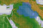
ASTER GDEMv2 30m Mesh for Iraq Pt2a
(Category: FSX > Terrain Mesh)
63.12Mb (386 downloads)
There are four parts of this mesh to download as separate files.
ASTER GDEM Version 2 is a 30 metre definition DEM, its better than the version 1 data that ERSDAC, of Japan and NASA originally released, but it does have its limitations.
GDEM has been obtained from a satellite that uses stereoscopic infrared scanning cameras, this brings with it problems in the resultant data.....where it sees the tops of trees, buildings etc, as the ground terrain.
If you look at the jpg image with the terrain type errors shown as a graph, you will see that the only 'safe' terrain to use this data with - in FSX - is scrubland, or desert terrain.
Its hopeless in defining the terrain in places like Europe - with all the artificial structures, (buildings) and different types of woodland, so any mesh I create from this data won't include areas like that....it will be more desert type terrain, and scrubland.
I won't be doing Greenland because something about the ice around Greenland, (or any other land mass with ice) it creates false data.
It does give enough fine data to reveal railway lines, and some roads though.
This mesh has been made for FSX only.
Grateful thanks to ERSDAC, and NASA for making this data freely available to the public.
ASTER GDEM
Copyright (c) 2009 - 2011 Earth Remote Sensing Data Analysis Center (ERSDAC) All rights reserved.
Posted Mar 4, 2012 05:56 by Wayne Evans
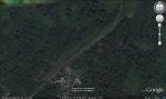
Aerodromo Amubri - Costa Rica
(Category: FS2004 > Scenery)
0.11Mb (386 downloads)
Aerodromo Amubri - Costa Rica. This airport is located in the province of Limon, Costa Rica, this area is belongs to the indigenous area of the Amubri.
Posted Mar 21, 2011 12:03 by Alberto Thomas - Costa Rica