


All Time Popular > Page 4558
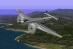
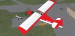
Junkers Ju-86k Upgrade
(Category: CFS1 > Aircraft)
1.08Mb (354 downloads)
CFS1 Junkers Ju-86k Upgrade.
Chilean Air Force - Fuerza Aerea de Chile
Now with accurate colors on non textured parts.
Original model creators: Bertil Nilsson & Mike Colclough.
Damage profile for CFS1, new panel and repaint with chilean markings: Edmundo Abad.
Posted Feb 26, 2010 05:58 by Edmundo Abad
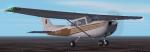
FS2004 Bryson Air Services C172 Textures
(Category: FS2004 > Props)
1.09Mb (354 downloads)
Textures for use with the default Skyhawk. Repaint by Don Brynelsen using the paintkit by Mark Rooks.
Posted Nov 21, 2009 12:04 by Don Brynelsen
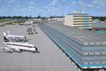
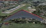
TJSJ 1962 LuisFSX Marin Airport, San Juan Puerto Rico
(Category: FSX > Scenery)
3.09Mb (353 downloads)
The "new" airport built in the late 50's is modelled here with the iconic hotel/ control tower complex, the new terminals and air cargo center, and some custom built hangars for Caribair and others. A flight line for the F-86's stationed there is provided. A few custom built high rises are tossed in. There isn't much eye candy included, so you can add your own! Approaches are designed on old Jeppeson charts of the period. The usual additional libraries required. Some AI thrown in, too. Recommend CalClassic AI. by Dan French
Posted Sep 21, 2021 02:02 by Dan French
Zorg en hoop airport-SMZO, Surinam
(Category: FSX > Scenery)
0.00Mb (353 downloads)
Zorg en Hoop Airport (IATA: ORG, ICAO: SMZO) is an airport located in the city of Paramaribo, Suriname. The runway length is only sufficient for smaller aircraft, airliners serving Paramaribo from the international Zanderij Airport 45 km south of the city
Posted Dec 23, 2015 06:28 by Jean Tsai
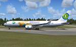
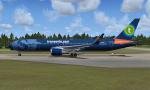
Level D Boeing 767-300 Winglet Transavia Textures
(Category: FSX > Payware)
10.93Mb (353 downloads)
5 liveries of Transavia for the payware Level D Boeing 767-300ER Winglet.
Textures by Peter Franeker.
Posted Nov 11, 2012 18:32 by Peter Franeker
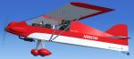
FSX Zippy Sport Red/Wt N8693W Textures
(Category: FSX > Props)
3.04Mb (353 downloads)
FSX Green Sky Adventures Zippy Sport repaint textures in red and white
for the fun flying Craig Richardson freeware Zippy Sport,
which you must have previously installed in FSX. Screenshots enclosed.
Easy installation. By Tom Tiedman.
Required files:
required file
Posted Nov 1, 2012 08:00 by Tom Tiedman
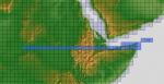
ASTER GDEMv2 30m mesh for Sudan & the Horn of Africa pt6
(Category: FSX > Terrain Mesh)
140.65Mb (353 downloads)
There are Eleven (11) parts of this mesh to download as separate files.
ASTER GDEM Version 2 is a 30 metre definition DEM, its better than the version 1 data that ERSDAC, of Japan and NASA originally released, but it does have its limitations.
GDEM has been obtained from a satellite that uses stereoscopic infrared scanning cameras, this brings with it problems in the resultant data.....where it sees the tops of trees, buildings etc, as the ground terrain.
If you look at the jpg image with the terrain type errors shown as a graph, you will see that the only 'safe' terrain to use this data with - in FSX - is scrubland, or desert terrain.
Its hopeless in defining the terrain in places like Europe - with all the artificial structures, (buildings) and different types of woodland, so any mesh I create from this data won't include areas like that....it will be more desert type terrain, and scrubland.
I won't be doing Greenland because something about the ice around Greenland, (or any other land mass with ice) it creates false data.
It does give enough fine data to reveal railway lines, and some roads though.
This mesh has been made for FSX only.
Grateful thanks to ERSDAC, and NASA for making this data freely available to the public.
ASTER GDEM
Copyright (c) 2009 - 2011 Earth Remote Sensing Data Analysis Center (ERSDAC) All rights reserved.
ASTER GDEM is a product of METI and NASA.
Posted Mar 17, 2012 10:06 by Wayne Evans
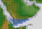
ASTER GDEMv2 30m mesh for Arabian Peninsula Pt7a
(Category: FSX > Terrain Mesh)
52.61Mb (353 downloads)
There are Twenty parts of this mesh to download as separate files.
ASTER GDEM Version 2 is a 30 metre definition DEM, its better than the version 1 data that ERSDAC, of Japan and NASA originally released, but it does have its limitations.
GDEM has been obtained from a satellite that uses stereoscopic infrared scanning cameras, this brings with it problems in the resultant data.....where it sees the tops of trees, buildings etc, as the ground terrain.
If you look at the jpg image with the terrain type errors shown as a graph, you will see that the only 'safe' terrain to use this data with - in FSX - is scrubland, or desert terrain.
Its hopeless in defining the terrain in places like Europe - with all the artificial structures, (buildings) and different types of woodland, so any mesh I create from this data won't include areas like that....it will be more desert type terrain, and scrubland.
I won't be doing Greenland because something about the ice around Greenland, (or any other land mass with ice) it creates false data.
It does give enough fine data to reveal railway lines, and some roads though.
This mesh has been made for FSX only.
Grateful thanks to ERSDAC, and NASA for making this data freely available to the public.
ASTER GDEM
Copyright (c) 2009 - 2011 Earth Remote Sensing Data Analysis Center (ERSDAC) All rights reserved.
ASTER GDEM is a product of METI and NASA.
Posted Mar 8, 2012 05:47 by Wayne Evans

Boeing 737-800 Derpy Mail Textures
(Category: FSX > Civil Jets)
10.37Mb (353 downloads)
Boeing 737-800 Derpy Mail (MLP:FIM) textures only for the default B737. For all of you flying bronies out there.
Posted Jan 22, 2012 05:49 by Max Moore
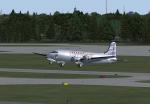

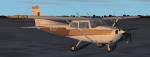
FSX/FS2004 DC-4 Braniff B Liner Textures
(Category: FSX > Vintage)
3.40Mb (353 downloads)
FSX/FS2004 Braniff "B" Liner textures for the JBK DC-4-1009 V.3 by Jens Kristensen. These textures represent NC65141 about 1946.
Textures by Gary Harper.
Required files:
required file
Posted Jul 15, 2011 00:23 by Gary Harper