


All Time Popular > Page 5017
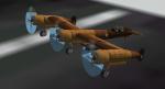
Blohm & Voss "P2 Warhawk" Crimson Skies Textures
(Category: FSX > Vintage)
2.56Mb (231 downloads)
This is a repaint for the Blohm and Voss model.
The repaint is a recreation of the P2 Warhawk in Crimson skies.
Repaint created by Garrett Scott and original model by Kazunori Ito.
Required files:
required file
Posted Sep 11, 2016 14:36 by Garrett Scott
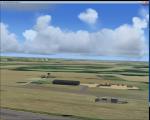
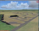
RAF Ramsbury, UK
(Category: FSX > Scenery)
0.80Mb (231 downloads)
RAF Ramsbury is a former Royal Air Force station located 5 miles (8.0 km) east-northeast of Marlborough, Wiltshire, England. Opened in 1942, it was used by both the Royal Air Force and United States Army Air Forces. During the war it was used primarily as a transport airfield.
With the end of military control Ramsbury was returned agricultural use. By the mid-1960s, much of the concrete had been removed.
Posted Apr 11, 2016 03:58 by Terry Boissel

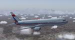
FSX Level-D B767 United Textures
(Category: FSX > Payware)
5.28Mb (231 downloads)
United new livery textures for the payware Level D B767-300
Posted Sep 4, 2015 17:53 by TRINO ROJAS

FS2004 Level-D B767-300ER China P.L.A.Air Force B-4025 textures
(Category: FS2004 > Payware)
7.93Mb (231 downloads)
FS2004 China P.L.A. Air Force B-4025 textures for the payware
Level-D 767-300ER
Posted Jan 3, 2015 00:01 by Liao Yitong
Peterborough Ontario
(Category: X Plane > Scenery)
25.28Mb (231 downloads)
X-Plane 9 And 10 Peterborough Ontario. Includes CYPQ Peterborough, CPJ5 Stirling, CPY4 Norwood, CPS2 Keene/Elmhirsts Resort, CNQ6 Keene/Elmhirsts Resort (water), CNF4 Lindsay, CFG8 Sturgeon Lake (water), CPV5 Head Lake (grass and water). OpenSceneryX required. Note: developed in 8.64 and tested in 9.70. By Jacques Brault.
Posted Nov 13, 2013 12:47 by uploader
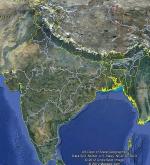
FSX India Airfield Locator
(Category: FS Navigation > Flight Simulator Navigation)
2.54Mb (231 downloads)
Tested on Windows XP and Windows 7.
This download adds airfield markers and ICAO id's found in FSX, and overlays them on Google Earth.
This file is for India.
There is also a seperate file with a list of basic airfield location details.
i.e: EGBB Birmingham Airport. Birmingham. N52* 27.23' W1* 44.88' alt325.
Also the tidying "My places" in Google Earth, file.
Other locator files to follow.
by Carl Vokes
Posted Nov 13, 2012 15:03 by carl vokes
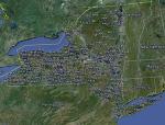
FSX New York Airfield Locator
(Category: FS Navigation > Flight Simulator Navigation)
2.61Mb (231 downloads)
Tested on Windows XP and Windows 7.
This download adds airfield markers and ICAO id's found in FSX, and overlays them on Google Earth.
This file is for New York. USA.
There is also a seperate file with a list of basic airfield location details.
i.e: EGBB Birmingham Airport. Birmingham. N52* 27.23' W1* 44.88' alt325.
Also the tidying "My places" in Google Earth, file.
Other locator files to follow.
by Carl Vokes
Posted Oct 31, 2012 18:18 by carl vokes
Isla del Maiz - Corn Island Nicaragua
(Category: FS2004 > Scenery)
0.18Mb (231 downloads)
Beautiful Caribbean island in Nicaragua.
Posted Jun 12, 2012 01:42 by Alberto Thomas
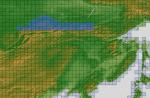
ASTER GDEMv2 30m mesh for Mongolia & surrounding areas Pt1.
(Category: FSX > Terrain Mesh)
245.29Mb (231 downloads)
There are Fourteen (14) parts of this mesh to download as separate files.
ASTER GDEM Version 2 is a 30 metre definition DEM, its better than the version 1 data that ERSDAC, of Japan and NASA originally released, but it does have its limitations.
GDEM has been obtained from a satellite that uses stereoscopic infrared scanning cameras, this brings with it problems in the resultant data.....where it sees the tops of trees, buildings etc, as the ground terrain.
If you look at the jpg image with the terrain type errors shown as a graph, you will see that the only 'safe' terrain to use this data with - in FSX - is scrubland, or desert terrain.
Its hopeless in defining the terrain in places like Europe - with all the artificial structures, (buildings) and different types of woodland, so any mesh I create from this data won't include areas like that....it will be more desert type terrain, and scrubland.
I won't be doing Greenland because something about the ice around Greenland, (or any other land mass with ice) it creates false data.
It does give enough fine data to reveal railway lines, and some roads though.
This mesh has been made for FSX only.
Grateful thanks to ERSDAC, and NASA for making this data freely available to the public.
ASTER GDEM
Copyright (c) 2009 - 2011 Earth Remote Sensing Data Analysis Center (ERSDAC) All rights reserved.
ASTER GDEM is a product of METI and NASA.
Posted Apr 3, 2012 06:12 by Wayne Evans

CFS2
Mitsubishi A6M5a Reisen 221-18 Kokutai Textures only
(Category: CFS2 > Aircraft)
1.82Mb (231 downloads)
CFS2
Mitsubishi A6M5a Reisen 221-18 Kokutai Textures only. Painted
over The B24 Guy's A6M5 Overhauled Model (Here).
Texture Folder complete with texture and damage files.Repaint by:Evan
G. Butterbrodt. 1.8MB
Posted Jun 10, 2008 11:31 by archive