


All Files > Page 1318
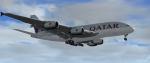

Airbus A380 Qatar A7-APA Package
(Category: FSX > Civil Jets)
29.13Mb (18109 downloads)
Project Airbus A380 Qatar, A7-APA, for FSX.
Includes VC and first class cabin.
Check "Zip file preview" to see photos.
You can find this aircraft under 'Project Airbus' in your FSX menu.
Repaint by Jim Fly
Posted Feb 18, 2014 11:36 by Jim Fly

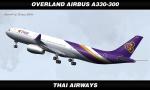
FSX/FS2004 Overland Airbus A330-300 - Thai Airways Textures
(Category: FS2004 > Payware)
5.48Mb (1791 downloads)
SMS Overland Airbus A330-300 in Thai Airways livery. Texture only for payware Simmer`S Sky Overland model. Repaint by Sergey Gleba.
Posted Feb 18, 2014 06:44 by Sergey Gleba aka serg09

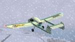
Anderson Greenwood AG-14
(Category: FS2004 > Props)
13.33Mb (1448 downloads)
The Anderson Greenwood AG-14 is a two-seat utility aircraft developed in the United
States in 1950. It is an all-metal, shoulder-wing monoplane. There were only 5
aircrafts built. One is still flying today in Florida.
This is a complete aircraft. Original by Tim Conrad, 9 repaints by Ingo Schwan.
Posted Feb 18, 2014 01:07 by Ingo Schwan
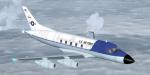
FSX Mc Donnell MD 220 package
(Category: FSX > Civil Jets)
5.14Mb (2662 downloads)
The Mc Donnell MD 220 was a business jet with 4 engines under the wings launched in 1959. It was in competition with the Lockheed Jetstar and only one prototype was built. Original model by Mike Stone, repaint by Andy Nott. Adaptation for FSX, 2D panels (no VC) for wide and standard screen, gauges by Philippe Wallaert. See instructions for installation and configuration in the readme.txt file. Credit: Mike Stone and Andy Nott.
Posted Feb 17, 2014 17:46 by Philippe Wallaert
Three Animated FSX Wind Turbines
(Category: FS Design > Scenery Design Objects)
0.35Mb (1297 downloads)
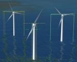
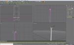
Three very low polygon count animated wind turbine models with night obstruction light. Each model can be scaled to the required blade length & also hub height. Based on the turbine models in the FSX Power Project, wind farms with hundreds of turbines can be constructed with friendly frame-rates. Gmax source files included for creating your own turbines with custom textures.
Posted Feb 17, 2014 16:37 by Ray Porter

Anderson Greenwood AG-14
(Category: FS2004 > Props)
13.33Mb (524 downloads)
The Anderson Greenwood AG-14 is a two-seat utility aircraft developed in the United
States in 1950. It is an all-metal, shoulder-wing monoplane. There were only 5
aircrafts built. One is still flying today in Florida.
This is a complete aircraft. Original by Tim Conrad, 9 repaints by Ingo Schwan.
Posted Feb 17, 2014 03:28 by Ingo Schwan
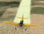
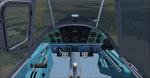
LET Z-37A Updated Package
(Category: FSX > Props)
88.02Mb (1762 downloads)
This is an update to the FS2004 Pavel Karasek, Zlin Z-37 Cmelak. The panel was made more FSX friendly, the VC glass, and prop textures replaced, plus texture thumbnails added. This package has both 2D and VC panels.
Posted Feb 16, 2014 23:16 by Michael E. Roberts
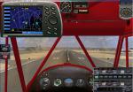
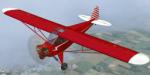
FSX Piper J3 Cub Modern Navigation Package
(Category: FSX > Props)
18.42Mb (2082 downloads)
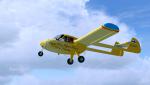
This pack uses the default Piper_J3Cub and adds a fourth model that uses all modern instruments.
A navigation pack is included as popup windows: Nav1 Nav2 COM1 COM2 - AUTOPILOT - ADF - Transponder - Audio
HSI - DME - NAV/GPS SWITCH - NAV/GPS INDICATOR LIGHT STARTER - FUEL SWITCH COMPASS - CLOCK FS9 GPS
Use all default FSX Gauges and a modified air file to add radio and navigation capabilities.
The aircraft uses the Red textures, and uses the red Piper Cub panel repaint by Andy Johnston.
Posted Feb 16, 2014 22:44 by Rick Herring
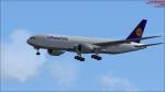
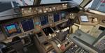
Boeing 777-200F Lufthansa Cargo Package
(Category: FSX > Civil Jets)
54.63Mb (9971 downloads)
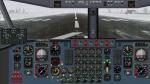
Lufthansa Boeing 777-200F "D-ALFB" Virtual Cockpit and FMC for FSX.
Lufthansa Boeing 777-200F "D-ALFB" package. Includes revised VC and FMC (via
Views-Instrument panel). Model features are Opening doors & Cargo doors,
detailed textures, accurate paint, dynamic shine & effects, dynamic flexing
wings that respond to turbulence, fully independent suspension, trim animation,
gear steering, accurate flight dynamics, spoiler animation, reflective cockpit
windows, crash effects, animated tilting bogies, full night lighting, ground
service vehicles when cargo
door open, (FSX - Go to Views - Instrument Panel -Posky Util), detailed virtual
cockpit and more. Added jetway (Ctrl J) and custom B777 sounds. See FMC docs.
FMC needs to be set in Flight Planning in FSX. (NOTE: you cannot enter into the
FMC direct)
Posted Feb 16, 2014 12:05 by LukasFSX
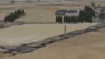
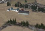
Bjedstrup Airfield (Fictional) Scenery
(Category: FSX > Scenery)
1.13Mb (169 downloads)
Bjedstrup Airfield fictional scenery at Skanderborg, Denmark.
Position gps N56 2,25' - E9 51,93'
Elevation 298 ft.
8 Runway Light.
To find this airfield - fly to Skanderborg Lake, the fly north.
Posted Feb 16, 2014 11:39 by Henrik Hansen