


All Files > Page 1576
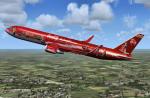
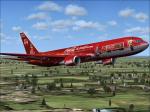
Level D Boeing 767-300 Coca Cola Promotions Textures
(Category: FSX > Payware)
5.12Mb (351 downloads)
Coca Cola Promotions textures for the payware Level D Boeing 767-300ER
This are two liveries of the Coca Cola Promotions an Boeing 767-300ER Winglet.
Textures by Peter Franeker.
Posted Nov 21, 2012 08:58 by Peter Franeker
Level D Boeing 767-300ER Friesland Promotions Textures
(Category: FSX > Payware)
2.58Mb (144 downloads)
Friesland Promotions textures for the payware Level D Boeing 767-300ER.
Textures by Peter Franeker.
Posted Nov 21, 2012 07:44 by Peter Franeker
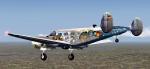
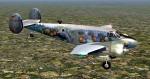
FS2004 (FSX) Beech D18S Aero Astro Design
(Category: FS2004 > Props)
43.83Mb (1997 downloads)
FS2004 (also works in FSX) Beech D18S Aero Astro Design. This is a complete aircraft with two Aero Astro Design liveries (German and US) for the great Beech D18S aircraft with VC by Milton Shupe. Repaints by Ingo Schwan.
Posted Nov 21, 2012 05:56 by Ingo Schwan
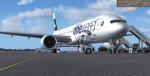
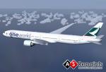
Boeing 777-300ER Cathay Pacific Airways/Oneworld Package
(Category: FSX > Civil Jets)
31.48Mb (7721 downloads)
Boeing 777-300ER with the Cathay Pacific Airways/Oneworld. Features are Opening doors & Cargo doors, detailed textures, accurate paint, dynamic shine & effects, dynamic flexing wings that respond to turbulence, fully independent suspension, trim animation, gear steering, accurate flight dynamics, spoiler animation, reflective cockpit windows, crash effects, animated tilting bogies, full night lighting, ground service vehicles when cargo
door open, (FSX - Go to Views - Instrument Panel -Posky Utility), detailed virtual cockpit and more. Model, VC model by Project Opensky and textures by Juan Rodriguez. Mods for FSX by Chris Evans.
Posted Nov 20, 2012 10:24 by Chris Evans


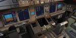
FSX A321 VC Night Lights
(Category: FSX > Panels)
2.94Mb (7265 downloads)
Replacement VC lighting for the FSX A321, to make night flying more enjoyable.
The default dome lighting was far too bright so this has been brought down to a realistic level. In addition to this most of the display lighting has been replaced with a blue/white LED style including a small glow effect. The overall mod means you can now enjoy night flying and the instrument lighting. Check out the before and after pictures in the
File info
Posted Nov 20, 2012 05:52 by Paul Davies
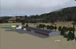
Fricktal Schupfart LSZI, Switzerland
(Category: FSX > Scenery)
1.74Mb (1019 downloads)
Scenery Fricktal Schupfart LSZI for FSX
The Scenery is located in the hills of the eastern Jura in Switzerland near Basel.
The airport is placed with images of googlemap and skyguide chart.
Posted Nov 20, 2012 04:59 by uploader
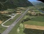
Raron LSMN/LSTA, Switzerland
(Category: FSX > Scenery)
3.88Mb (2282 downloads)
Scenery Raron LSMN/LSTA for FSX
The Scenery is located in the valley of Valais in Switzerland.
The airport is placed with images of googlemap, skyguide and ourairport.
Full Runway made usable, sorry for the fictional scenery, but wanted to make it usable with jets.
Posted Nov 20, 2012 04:57 by uploader

Raron LSTS, Switzerland
(Category: FSX > Scenery)
0.49Mb (967 downloads)
Scenery Raron LSTS for FSX.
The Scenery is located in the Obersimmental in the Bernese Alps Switzerland.
The runway is only opened for the Hunters and Oldtimers once a year.
Posted Nov 20, 2012 04:53 by uploader
Boeing 777-300ER Cathay Pacific Airways/Oneworld
(Category: FS2004 > Civil Jets)
9.46Mb (1950 downloads)
This is repaint for the Project Open Sky Boeing 777-300ER with the Cathay Pacific Airways/Oneworld livery, textures and model included
Juan Rodriguez
Posted Nov 20, 2012 03:17 by Chris E


FSX Lear 45 VC Night Lights
(Category: FSX > Panels)
1.32Mb (3302 downloads)
Replacement VC lighting for the FSX Lear 45, to make night flying more enjoyable.
The default dome lighting was far too bright so this has been brought down to a realistic level. In addition to this most of the display lighting has been replaced with a blue/white LED style including a small glow effect. The overall mod means you can now enjoy night flying and the instrument lighting. Check out the before and after pictures in the
File info
Posted Nov 19, 2012 17:57 by Paul Davies