


All Files > Page 1625

A2A Albatros D.III (Oeffag), Merian Cooper, 1920 Texturex
(Category: FSX > Payware)
11.31Mb (726 downloads)
Personal paint scheme of cpt. Merian C. Cooper of 7.Eskadra (Kosciuszko Squadron), 1919/20.
Textures only for the payware A2A/AF Albatros D.III (Oeffag)
Posted Sep 9, 2012 19:48 by Lukasz Kubacki
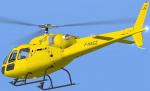
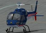
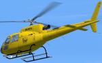
CharlieVictor Eurocopter AS355 Heli and Co Textures
(Category: FS2004 > Payware)
2.26Mb (221 downloads)
Textures only for the payware Eurocopter AS-355N from Charlie Victor. Repaint of the Heli and Co F-HACZ by Simon Iglesias "Heli3".
Posted Sep 9, 2012 19:46 by Simon Iglesias
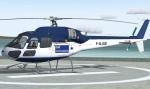
CharlieVictor Eurocopter AS355 F-GJSE Textures
(Category: FS2004 > Payware)
2.28Mb (135 downloads)
Textures only for the payware Eurocopter AS-355N from Charlie Victor. Repaint of the F-GJSE with Cathelicopters stickers by Simon Iglesias "Heli3".
Posted Sep 9, 2012 19:43 by Simon Iglesias
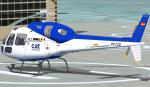
CharlieVictor Eurocopter AS355 EC-LCD Textures
(Category: FS2004 > Payware)
2.29Mb (201 downloads)
Textures only for the payware Eurocopter AS355 from Charlie Victor. Repaint of the Sky Helicópteros EC-LCD as Cathelicopters by Simon Iglesias "Heli3".
Posted Sep 9, 2012 19:40 by Simon Iglesias
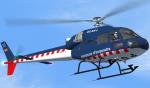
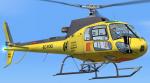
CharlieVictor Eurocopter AS355 Mossos d'esquadra EC-KYJ Textures
(Category: FS2004 > Payware)
2.28Mb (204 downloads)
Textures only for the payware Eurocopter AS355 from Charlie Victor. Repaint for the Catalan police Mossos d'esquadra by Simon Iglesias "Heli3".
Posted Sep 9, 2012 19:38 by Simon Iglesias
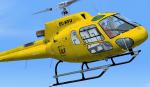
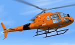
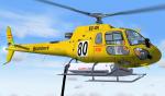
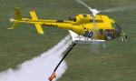
HeliDevelopment AS-350B3 Generalitat de Catalunya EC-FOQ Textures
(Category: FS2004 > Payware)
6.27Mb (176 downloads)
Textures only for the payware HeliDevelopment Eurocopter AS-350B3 Ecureuil for FS2004. EC-FOQ repaint by Simon Iglesias "Heli3".
Posted Sep 9, 2012 19:03 by Simon Iglesias
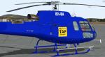
HeliDevelopment AS-350B3 TAF Helicopters Textures
(Category: FS2004 > Payware)
6.01Mb (122 downloads)
Textures only for the payware HeliDevelopment Eurocopter AS-350B3 Ecureuil for FS2004. EC-KFU repaint by Simon Iglesias "Heli3".
Posted Sep 9, 2012 18:59 by Simon Iglesias
HeliDevelopment AS-350B3 HelitransPyrinees Textures
(Category: FS2004 > Payware)
5.98Mb (102 downloads)
Textures only for the payware Eurocopter AS-350B3 Ecureuil from HeliDevelopment. Repaint of EC-JTX from HelitransPyrinees by Simon Iglesias "Heli3".
Posted Sep 9, 2012 18:53 by Simon Iglesias

HeliDevelopment AS-350B3 TAF Helicopters EC-JEA textures
(Category: FS2004 > Payware)
6.00Mb (86 downloads)
Textures only for the payware Eurocopter AS-350B3 Ecureuil from HeliDevelopment by Simon Iglesias "Heli3".
Posted Sep 9, 2012 18:45 by Simon Iglesias
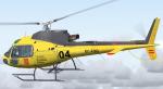
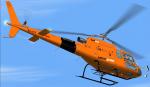
HeliDevelopment AS-350B3 Bombers Generalitat de Catalunya textures
(Category: FS2004 > Payware)
5.77Mb (251 downloads)
Textures only for the payware HeliDevelopment Eurocopter AS-350B3 Ecureuil. Repaint of Bombers de la Generalitat de Catalunya by Simon Iglesias "Heli3".
Posted Sep 9, 2012 18:41 by Simon Iglesias