


All Files > Page 1653
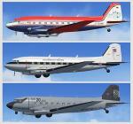
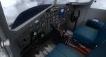
Basler BT-67 Base Package V2
(Category: FSX > Vintage)
39.07Mb (12504 downloads)
FSX Basler BT-67 Base Pack V2
The BT-67 is a turbo-prop conversion of the
classic Douglas DC-3/C-47. V2 has a new panel
layout, some new gauges, and new flight
dynamics. No 2D panel and aliased default
sound only. By Daniel Fuernkaess (paints and
research), Manfred Jahn (models), Alexander
M. Metzger (flight dynamics and docs) and
Hansjoerg Naegele (gauges, animation and
docs). Minimum system-requirements: FSX
SP2. (previous version had 3684 downloads)
Posted Jul 20, 2012 07:42 by uploader
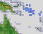
FSX ASTER_imp GDEMv2 30m mesh for Papua New Guinea pt2
(Category: FSX > Terrain Mesh)
161.94Mb (532 downloads)
"imp" means imperfect, as other mesh I have already processed is of areas that have very little vegetation cover - over the land, or has large urban areas.
This "imp" mesh will include some slight discrepancies of altitude (in the case of forested areas - by a magnitude sometimes of +15 metres-depending on how tall the trees are, in the jungle or forest canopy) over urban areas, or areas with a lot of vegetation cover - due to the limitations of the ASTER satellites infra red scanning cameras, and the software used to process the DEM data.
Areas where there is little vegetation cover, or non urban areas, the terrain should have truer values.
But I feel this ASTER DEM data is so good - why let it all go to waste - especially flying over lovely Pacific islands?
So you FSX users out there will have to take all this into account when using this mesh.
Grateful thanks to ERSDAC, and NASA for making this data freely available to the public.
ASTER GDEM
Copyright (c) 2009 - 2011 Earth Remote Sensing Data Analysis Center (ERSDAC) All rights reserved.
ASTER GDEM is a product of METI and NASA.
Posted Jul 20, 2012 04:51 by Wayne Evans

FSX ASTER_imp GDEMv2 30m mesh for Papua New Guinea pt1
(Category: FSX > Terrain Mesh)
43.09Mb (518 downloads)
"imp" means imperfect, as other mesh I have already processed is of areas that have very little vegetation cover - over the land, or has large urban areas.
This "imp" mesh will include some slight discrepancies of altitude (in the case of forested areas - by a magnitude sometimes of +15 metres-depending on how tall the trees are, in the jungle or forest canopy) over urban areas, or areas with a lot of vegetation cover - due to the limitations of the ASTER satellites infra red scanning cameras, and the software used to process the DEM data.
Areas where there is little vegetation cover, or non urban areas, the terrain should have truer values.
But I feel this ASTER DEM data is so good - why let it all go to waste - especially flying over lovely Pacific islands?
So you FSX users out there will have to take all this into account when using this mesh.
Grateful thanks to ERSDAC, and NASA for making this data freely available to the public.
ASTER GDEM
Copyright (c) 2009 - 2011 Earth Remote Sensing Data Analysis Center (ERSDAC) All rights reserved.
ASTER GDEM is a product of METI and NASA.
Posted Jul 20, 2012 04:05 by Wayne Evans

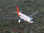
Airbus A319-112 Chengdu Airlines
(Category: FSX > Civil Jets)
14.09Mb (1752 downloads)
Chengdu Airlines Airbus A319-112 for Flight Simulator X. Aircraft model and texture of Chengdu Airlines are included, along with panel, sound and virtual cockpit from the default A321. Original aircraft by Project Airbus, textures by Lingyuan He from China.
Posted Jul 19, 2012 07:09 by Lingyuan He
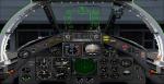
FSX BAC TSR2 Updated Package
(Category: FSX > Military)
23.10Mb (5896 downloads)
I updated Kazunori Ito's FS2004/2002 BAC TSR.2 by replacing the panel with Henry Kelsall's TSR2 panel that I re gauged with FSX gauges. I also added HJG's Concorde Rolls Royce Olympus sound set, Rob Barendregt & Doug Dawson's Sonic Boom and afterburner effects. 2d panel but no VC panel.
Posted Jul 19, 2012 05:05 by Michael E. Roberts
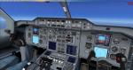
Tom Ruth A300-600R Panel Redux
(Category: FSX > Panels)
11.45Mb (5796 downloads)
A remastered panel for the Tom Ruth A300-600 aircraft. Can also be used in the Tom Ruth A310 aircraft. Includes callouts and FMC.
Posted Jul 18, 2012 19:55 by Skilaeb Dygsbi
FSX ASTER_imp GDEMv2 30m mesh for South Korea (ROK)
(Category: FSX > Terrain Mesh)
43.88Mb (816 downloads)
"imp" means imperfect, as other mesh I have already processed is of areas that have very little vegetation cover - over the land, or has large urban areas.
This "imp" mesh will include some slight discrepancies of altitude (in the case of forested areas - by a magnitude sometimes of +15 metres-depending on how tall the trees are, in the jungle or forest canopy) over urban areas, or areas with a lot of vegetation cover - due to the limitations of the ASTER satellites infra red scanning cameras, and the software used to process the DEM data.
Areas where there is little vegetation cover, or non urban areas, the terrain should have truer values.
But I feel this ASTER DEM data is so good - why let it all go to waste - especially flying over lovely Pacific islands?
So you FSX users out there will have to take all this into account when using this mesh.
Grateful thanks to ERSDAC, and NASA for making this data freely available to the public.
ASTER GDEM
Copyright (c) 2009 - 2011 Earth Remote Sensing Data Analysis Center (ERSDAC) All rights reserved.
ASTER GDEM is a product of METI and NASA.
Posted Jul 18, 2012 19:22 by Wayne Evans
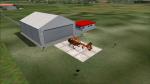
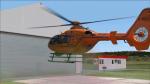
Christiph 17 Hangar at Airfiled Durach, Germany
(Category: FS2004 > Scenery)
0.59Mb (775 downloads)
The New Location of the German Rescue Helicopter "Christoph 17" is at the Airfield Durach (EDMK)
Compatible also with VFR Airfields of CR-Software
Posted Jul 18, 2012 17:10 by benimix - Benedikt Fröhlich
FSX ASTER_imp GDEMv2 30m mesh for Solomon Islands
(Category: FSX > Terrain Mesh)
15.35Mb (599 downloads)
"imp" means imperfect, as other mesh I have already processed is of areas that have very little vegetation cover - over the land, or has large urban areas.
This "imp" mesh will include some slight discrepancies of altitude (in the case of forested areas - by a magnitude sometimes of +15 metres-depending on how tall the trees are, in the jungle or forest canopy) over urban areas, or areas with a lot of vegetation cover - due to the limitations of the ASTER satellites infra red scanning cameras, and the software used to process the DEM data.
Areas where there is little vegetation cover, or non urban areas, the terrain should have truer values.
But I feel this ASTER DEM data is so good - why let it all go to waste - especially flying over lovely Pacific islands?
So you FSX users out there will have to take all this into account when using this mesh.
Grateful thanks to ERSDAC, and NASA for making this data freely available to the public.
ASTER GDEM
Copyright (c) 2009 - 2011 Earth Remote Sensing Data Analysis Center (ERSDAC) All rights reserved.
ASTER GDEM is a product of METI and NASA.
Posted Jul 18, 2012 09:14 by Wayne Evans
Aero Files Vagar Airport Afcad Update
(Category: FS2004 > Scenery)
0.01Mb (247 downloads)
This is an Afcad update for the Vagar Airport scenery from Aero Files. This update includes a runways extension as well as a ground frequency and general aviation parkings whitch have been transformed into small gates for bigger aircrafts and fot getting more AI traffic to the airport. This file is only for Microsoft Flight Simulator 2004.
Readme file is included.
Posted Jul 18, 2012 09:02 by Yakkifly