


All Files > Page 4966
FSX
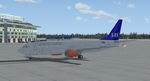
Boeing 737-800 SAS Textures.
(Category: FSX > Civil Jets)
3.53Mb (5319 downloads)
FSX
Boeing 737-800 SAS Textures.
Used the default Boeing 737. Jakob "Sealpower" Sällström.
3.6MB
Posted Jun 23, 2008 14:17 by archive
FSX
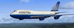
Boeing 747-400 United Textures files
(Category: FSX > Civil Jets)
5.95Mb (7354 downloads)
FSX
Boeing 747-400 United Textures files.
Texture Files Only for the 747-400 FSX. Frank McCall. 6.1MB
Posted Jun 23, 2008 14:17 by archive

2.36Mb (1418 downloads)
FSX
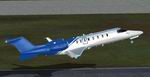
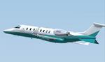
Lear 45 Ice Blue Textures - for use with the default FSX
Lear 45. Jeff Smith. 1.9MB
Posted Jun 23, 2008 14:17 by archive
2.36Mb (1418 downloads)
FSX
Lear 45 Dark Blue/White Textures - for use with the default
FSX Lear 45. Jeff Smith. 1.9MB
Posted Jun 23, 2008 14:17 by archive
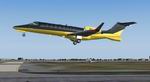
FSX
Learjet 45 TEAL Textures
(Category: FSX > Civil Jets)
2.36Mb (2703 downloads)
FSX
Learjet 45 TEAL Textures -
for use with the default FSX Lear 45. Jeff Smith. 2.4MB
Posted Jun 23, 2008 14:17 by archive
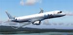
FSX
Embraer ERJ-195 FlyBe
(Category: FSX > Civil Jets)
1.40Mb (16998 downloads)
FSX
Embraer ERJ-195 FlyBe The
first aircraft to enter was deliverd to FlyBe in mid 2006. The
aircraft is the latest addition to Embraers production line
and has over 160 orders from airlines world wide. I originaly
downloaded this aircraft from Simviation, FS2004 Jets bud have
modified it to suit FSX. Includes deafault FSX CRJ-900 panel
and sound, plus thumbnail to apear on FSX's aircraft select
list. Thanks to J R Lucariny for original FS2004 aircraft. 1.4MB
Posted Jun 23, 2008 14:17 by archive
FSX
Learjet 45 Black/ Gold Textures.
(Category: FSX > Civil Jets)
2.19Mb (4714 downloads)
FSX
Learjet 45 Black/ Gold Textures. -
for use with the default FSX Lear 45. Jeff Smith. 2.2MB
Posted Jun 23, 2008 14:17 by archive
FSX
Boeing 787-8 NWA Northwest Airlines
(Category: FSX > Civil Jets)
1.58Mb (5055 downloads)
FSX
Boeing 787-8 NWA Northwest Airlines
including the Animated Ground Servicing (AGS). Model design
and paint by: Camil Valiquette. 1.6MB
Posted Jun 23, 2008 14:17 by archive
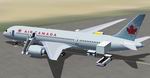
FSX
Boeing 787-8 Air Canada
(Category: FSX > Civil Jets)
1.66Mb (5260 downloads)
FSX
Boeing 787-8 Air Canada including
the Animated Ground Servicing (AGS). Model design and paint
by: Camil Valiquette. 1.7MB
Posted Jun 23, 2008 14:17 by archive
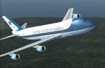
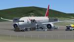
FSX
Boeing 747-200 Air Force One
(Category: FSX > Civil Jets)
4.17Mb (12841 downloads)
FSX
Boeing 747-200 Air Force One.
Dynamic Shine New 3D wheel with fixed rudder movement Fully
animated control surfaces Fully independent suspension Main
gear steering Trim Animation Opening Passenger, Cargo Doors
Dynamic flexing wings Animated tilting bogies Rolling wheels
Animated thrust reversers Fully reflective textures.(No virtual
cockpit). Original aircraft model by Project Opensky Team, repaint
Bill Kovatchev. 4.3MB
Posted Jun 23, 2008 14:17 by archive