


All Files > Page 931
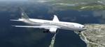
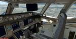
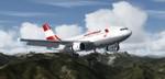
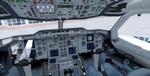
FSX/P3D Boeing 777-200LR Ceiba Intercontinental Package
(Category: FSX > Civil Jets)
52.65Mb (2690 downloads)
FSX/P3D Boeing 777-200LR Ceiba Intercontinental Package Virtual Cockpit and working FMC.
Ceiba Intercontinental is an airline based in Equatorial Guinea on the continent of Africa. Ceiba currently operate (2016) 2 Boeing 777-200 aircraft (one is in storage). Includes revised VC and Honeywell FMC (via Views-Instrument panel). Project Opensky model features opening doors & cargo doors, detailed textures, accurate paint, dynamic shine & effects, dynamic flexing wings that respond to turbulence, fully independent suspension, trim animation, gear steering, accurate flight dynamics, spoiler animation, reflective cockpit windows, crash effects, animated tilting bogies, full night lighting, stairs, ground service vehicles when cargo doors open, (FSX - Go to Views - Instrument Panel -Posky Util. In P3D go to Vehicle-Instrument panel - ), detailed virtual cockpit and more. Added custom B777 sounds. To use FMC - Go to Views - Intrument panel - FMC. See FMC docs. Fantastic native FSX model by Skyspirit/Project Opensky. . Jetway exits. I have included the fine textures by Alejandro Magadan. Zip preview for images. Prepared, tested and assembled for FSX by Chris Evans.
Posted Jul 19, 2016 07:56 by chris evans
 at La Guardia Airport, NY.jpg-thumb.jpg)
.jpg-thumb.jpg)
FSX Boeing 757-200 'N757AF' (Donald Trump) - Texture Only
(Category: FSX > Civil Jets)
6.14Mb (3082 downloads)
I decided to do this texture after watching a YouTube video about Mr Trump's personal aircraft, the Boeing 757-200. I don't consider myself to be a Trump fan, but I was never the less very much impressed. Revised textures by A. Ludick. Requires the Project Opensky Boeing 757-200 updated for FSX
Required files:
required file
Posted Jul 19, 2016 05:43 by Andre Ludick
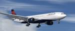
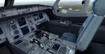
FSX/P3D Airbus A330-300 Delta Airlines package
(Category: FSX > Civil Jets)
39.79Mb (6363 downloads)
FSX/P3D Airbus A330-300 Delta Airlines package. As of 2016, Delta Airlines operate 29 Airbus A330-300 with a further 2 on order. Includes VC. Model and VC by Thomas Ruth. I included the great textures by Mike Pearson. Includes FMC by Garret Smith. Includes A330 manual. Custom A330 sounds included. Packaged by Chris Evans
Posted Jul 18, 2016 08:29 by chris evans
Airbus A310-300 Austrian Airlines package
(Category: FSX > Civil Jets)
36.62Mb (2559 downloads)
Airbus A310-300 Austrian Airlines package for FSX.
Austrian operated 4 Airbus A310-300 between 1988 and 2004.
Includes VC. Model and VC by Thomas Ruth. I included the great textures by Michael Pearson.
Includes FMC by Garret Smith, working wipers and more. A330 sounds and manual included. Please read the manual to understand the panel! Custom packaged by Chris Evans
Posted Jul 17, 2016 04:24 by chris evans
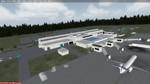
Gainsville, KGNV, Florida
(Category: FSX > Scenery)
36.91Mb (690 downloads)
KGNV, Gainesville, Florida. This airport has been designed and tested for use in FSX and P3D. All buildings, taxiways and ground textures have been modeled after the real airport. Note that Jetway's are currently stationary but will updated to function in later versions. Add-on Airport designed by LKP Designs.
Posted Jul 17, 2016 02:27 by uploader
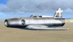
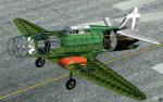
FSX Caproni Campini Fix
(Category: FSX > Vintage)
1.34Mb (611 downloads)
This is a fix for the Caproni Campini, which displays the fuselage interior correctly in FSX when pressing the spoiler key. Fix by the IS4G Group, designer of the original model. Uploaded on behalf of IS4G Group by Michael Pook.
Posted Jul 16, 2016 16:27 by Michael Pook
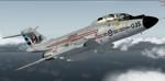
FSX/P3D McDonnell F-101B Voodoo Package
(Category: FSX > Military)
83.80Mb (5379 downloads)
McDonnell F-101B Voodoo Package. This is an update of Henk Schuitemaker's awesome revision of the Alphasim freeware McDonnell F-101B Voodoo for FSX/P3D, to include some more paints and with reflective and specular shine. It is a complete package and includes two models; CFB2 is the initial production model as first delivered to both the USAF and those delivered new to the Royal Canadian Air Force, starting in 1959. CFBR is the later production model (blocks 115 and 120) with infra-red sensor ahead of the cockpit. Starting in 1961, the majority of aircraft were brought up to the later standard so this represents the final appearance of the Voodoo in US and Canadian service. Model by Alphasim, updated for FSX by Henk Schuitemaker, additional updates by Dave Quincey
Posted Jul 16, 2016 04:20 by uploader
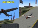
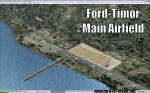
Ford-Timor (Jump Ramp Heaven)
(Category: FS2004 > Scenery)
3.65Mb (266 downloads)
6 different layers in one pack. This scenery pack is a fun experiment in Jump Ramp development - to get aircraft to launch into the air.
Many different angles and many different challenges for your fun flying pleasure.
Contains lots of small and large Jump Ramps, a couple of Ski Ramps and a Grass up/down Hill Runway.
Also contains an Aircraft Carrier with two jump ramps and an Airship with a runway and jump ramp on top.
All set up on 6 different height levels - absolute fun flying and some great challenges for takeoff and landings.
BONUS AIRFIELDS
For those that already have Ford-Blackhawk, Ford-Brazil and Ford-Switzerland installed - a collection of files are included in the Ford-Timor project that will add ramps and jumps to these packages.
Slideshow to show you what is included: http://www.ford-tri-motor.net/Slideshows/JUMP_RAMP_HEAVEN.html
Posted Jul 16, 2016 01:34 by Garry J. Smith
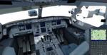
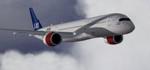
FSX/P3D Airbus A350-900 Scandinavian Airlines
(Category: FSX > Civil Jets)
50.29Mb (2869 downloads)
FSX/P3D Airbus A350-900 Scandinavian Airlines (SAS).
Sweden's flag carrier airline has (as of 2016) 8 Airbus A350-900 on order. The 1st deliveries are expected in 2019.
Textures by Emiliano Rujano.
Assembled using the pack base by FSPainter and config updated by Mees Jansen with Thomas Ruth's A330 panel with added Garret Smith's FMC and some further edits by Chris Evans.
Posted Jul 15, 2016 07:26 by chris evans
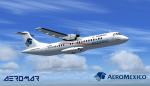
ATR 72-500 Aeromexico Express
(Category: FSX > Props)
36.10Mb (3413 downloads)
ATR 72-500 Aeromexico Express. Model by ISDT. Textures by Luis Enrique R.. 2d panel but no VC
Posted Jul 14, 2016 14:38 by Luis Enrique R.