


All Files > Page 1583
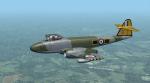
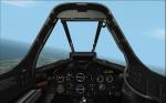
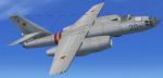
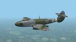
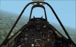
Alphasim Gloster Meteor F8 Update
(Category: CFS2 > Aircraft)
21.21Mb (1525 downloads)
Following the F3, here's then the upgrade of the Alphasim Gloster Meteor F8 with 8 new skins and new panel.
Posted Oct 15, 2012 16:30 by Morton
SHRS F-111 Aircraft Package (with missing effects)
(Category: FSX > Military)
51.43Mb (18202 downloads)
If you ever wanted to fly the F-111 skimming the tree tops at high speeds and whip around a mountain in a 60 degree bank while the autopilot does all the work, then this is the aircraft package for you. Our update has the only True Terrain Following Radar system with Pitch and Roll Stabilization that looks ahead of the aircraft to avoid mountains. It is integrated into the Autopilot and Instrument systems for Auto or Manual TF operation. The autopilot system models the real F-111 autopilot Stability Augmentation Modes with pitch and roll sub-channels. Control Stick Steering uses Pitch and/or Roll control stick input to override the pitch and/or roll autopilot channel(s) without disengaging the autopilot settings. The autopilot settings are re-engaged using a button on your control stick (bound to the "t" key) returning the aircraft to autopilot control. There are 4 different Custom 2D and VC Cockpits, Aircraft included are F-111E, F-111F, F-111G, FB-111A, FB-111A with pre AMPS avionics, and YFB-111A. 16 Custom textures with a description for that tail number in the aircraft details menu. Over 110 functional gauges and switches. Included is a custom sound package. See the features Doc for more details. For maximum enjoyment please read the documentation!!! This package is based on the Alphasim F-111 freeware aircraft and is highly modified for FSX SP2 and Acceleration. Fixed missing effects.
Posted Oct 15, 2012 12:15 by Steven Hess and Roman Stoviak
Ilyushin IL-28 Beagle Updated Package
(Category: FSX > Military)
51.07Mb (2927 downloads)
I updated Ralf Kreibich's FS2004 Ilyushin IL-28 Beagle by reworking the panel config file. I kept it 90 percent original. I also added texture thumbnails and HJG's CV990a smoke effects. No VC panel.
Posted Oct 15, 2012 09:46 by Michael E. Roberts
Tu-104 and Tu-124 Russian Panels
(Category: FSX > Panels)
7.47Mb (1081 downloads)
I updated the panel config file for the Samdim Tu-124 keeping it 90 percent origional. this is a 2D panel only, No VC. Can be used for either the Tu-104 or Tu-124.
Required files:
required file
Posted Oct 15, 2012 01:12 by Michael E. Roberts
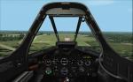
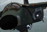
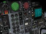
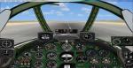
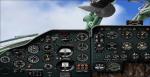
Alphasim Gloster Meteor F3 Update
(Category: CFS2 > Aircraft)
16.30Mb (743 downloads)
These textures will give your Meteor a much more realistic and detailed look than the old originals. And a new widescreen monitor panel is included as well.
Posted Oct 14, 2012 20:01 by Morton
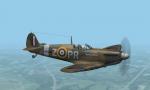
Battle of Britain Spitfires
(Category: CFS2 > Aircraft)
9.36Mb (2221 downloads)
The Aeroplane Heaven Spit MK1 really needed some new skins and a better panel. So here it is:
9 new skins
New 1680x1050 widescreen 2D panel
Reworked dynamic shine, weapons etc
Posted Oct 14, 2012 16:37 by Morton
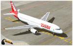
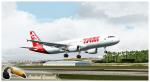
FSX/FS2004 Airbus A320 Tam Textures
(Category: FS2004 > Civil Jets)
10.87Mb (2335 downloads)
Tam is a Brazilian airline, the largest in Latin America and one of the 20 largest world. Is a leader in passengers carried across the southern hemisphere. Photoreal textures in 32 bit format for the freeware Project Airbus A320 v2.1 (model not included). Repaint be Manuel Jose.
Posted Oct 14, 2012 14:19 by Manuel Jose Larrahondo Burgos
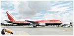
Avianca Boeing 767-300
(Category: FS2004 > Civil Jets)
13.80Mb (1948 downloads)
Avianca is the flag carrier airline of Colombia. It is the largest airline in Colombia and a major one in Latin America; Avianca together with its subsidiaries has the most extended network of (both passenger and cargo) destinations in the Americas and one of the largest and most modern aircraft fleet in the continent. Avianca photoreal textures in the 90's livery colors.Textures in 32 bit format for the SkySpirit2010 767-300 v5 (model included). Repaint by Manuel Jose Larrahondo Burgos
Posted Oct 14, 2012 13:28 by Manuel Jose Larrahondo Burgos | SkySpirit2010 Team
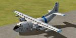
Fairchild C123 K Provider Air America
(Category: FSX > Military)
7.89Mb (6504 downloads)
The C123 provider was developped after WW2 (first flight in 1949) and was used by USAF during the Vietnam war. Here is the variant "Air America" (remember: the movie with Mel Gibson) with all moving parts. Credits: V.Zhyhulskiy for the original splendid model. Adapatation to FSX, VC and 2D wide screen panel, GPWS callout by Philippe Wallaert. See readme.txt and readme.doc files for installation and configuration. Enjoy!
Posted Oct 14, 2012 04:04 by Philippe Wallaert
FS2004 Classic Style Splashscreen Collection
(Category: Videos/Splashscreens > Splashscreens)
8.87Mb (275 downloads)
FS9 Classic Splash Addon Pack. This is a collection of FS9 splash screens that I made mostly from my own simming adventures. I used three programs (Photoimpression, MS Picture It & MS Paint) to make these. I went with a classic theme. These files are already sized and ready to go. Read the included readme file for install. Check them out! By: Dwayne Frye (Blaze)
Posted Oct 13, 2012 21:30 by Dwayne Frye